THIS AVALANCHE FORECAST EXPIRED ON March 15, 2014 @ 6:55 am
Avalanche Forecast published on March 14, 2014 @ 6:55 am
Issued by Andy Anderson - Tahoe National Forest - Sierra Avalanche Center

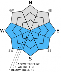
This morning the avalanche danger remains LOW for all elevations and aspects. As the day warms up loose wet snow instabilities will become possible and pockets of MODERATE avalanche danger may form on the E-SE-S-SW-W aspects. The southerly aspects that receive the most sunshine will be the most suspect.

2. Moderate

?

Above Treeline
Heightened avalanche conditions on specific terrain features. Evaluate snow and terrain carefully; identify features of concern.

2. Moderate

?

Near Treeline
Heightened avalanche conditions on specific terrain features. Evaluate snow and terrain carefully; identify features of concern.

2. Moderate

?

Below Treeline
Heightened avalanche conditions on specific terrain features. Evaluate snow and terrain carefully; identify features of concern.
    Heightened avalanche conditions on specific terrain features. Evaluate snow and terrain carefully; identify features of concern.
Avalanche Problem 1: Loose Wet
  • Type ?
  • Aspect/Elevation ?
  • Likelihood ?
    Certain
    Very Likely
    Likely
    Possible
    Unlikely
  • Size ?
    Historic
    Very Large
    Large
    Small

Some loose wet snow instabilities may become possible by this afternoon on the sun exposed E-SE-S-SW-W aspects. Since the snowpack experienced another solid refreeze last night and it has been through several melt freeze cycles, the majority of any wet snow instabilities that do occur today should remain small and limited in distribution. Small roller balls, small pinwheels, and small loose wet snow slides may occur today, but they should not entrain very much snow. On the most sun-exposed slopes a few isolated wet snow instabilities could move enough snow to cause problems for backcountry travelers.

recent observations

Yesterday on Red Lake Peak, a mix of scoured surfaces and isolated small wind slabs existed on exposed near and above treeline N-NE-E aspects. Tests and observations did not reveal any signs of instabilities associated with the lingering small wind slabs unless they existed on an unsupported test slope. Below treeline on the N aspects 1 to 3 inches of soft snow remained above the frozen rain crust in areas sheltered from the sun and wind.

On the sun exposed SE-S-SW aspects some melting and softening did occur creating a layer of soft melt-freeze snow that measured 1 inch in depth at 9400 ft at 12:30 pm and about 2 inches in depth at 8000 ft. at 1 pm. This softer surface snow rested on top of a thick and supportable layer of frozen melt-freeze snow and rain crusts. The E aspects remained frozen above 8500 ft. in this area yesterday. No signs of wet snow instabilities existed as of 1 pm.

Weather and CURRENT CONDITIONS
weather summary

A small weak low pressure moving through the Pacific Northwest will push a few isolated clouds over the forecast area this morning. By this afternoon these clouds should dissipate leaving sunny clear skies. The forecast calls for daytime highs to climb into the upper 40's and low 50's above 7000 ft. today and tomorrow. Light to moderate W winds may arise today. Tonight the winds will shift to the NE and NW and continue, but they should calm down at all elevations tomorrow as the high pressure ridge returns to the area.

CONDITIONS ALONG THE SIERRA CREST BETWEEN 8200 FT. AND 9200 FT. IN THE LAST 24 HOURS
6am temperature: 26 to 36 deg. F.
Max. temperature: 44 to 49 deg. F.
Average ridgetop wind direction: Northeast to west
Average ridgetop wind speed: 10 to 20 mph
Maximum ridgetop wind gust: 35 mph
New snowfall: 0 inches
Total snow depth: 42 to 53 inches
Two-Day Mountain Weather Forecast Produced in partnership with the Reno NWS
For 7000 ft. to 8000 ft.
Friday Friday Night Saturday
Weather: Some patchy clouds in the morning becoming sunny by the afternoon. Clear Sunny
Temperatures: 45 to 52 deg. F. 22 to 29 deg. F. 47 to 54 deg. F.
Mid Slope Winds: West Northwest shifting to the northeast after midnight Variable
Wind Speed: 5 to 15 mph 10 to 15 mph with gusts to 25 mph Light
Expected snowfall: 0 0 0
For 8000 ft. to 9000 ft.
Friday Friday Night Saturday
Weather: Some patchy clouds in the morning becoming sunny by the afternoon. Clear Sunny
Temperatures: 42 to 50 deg. F. 25 to 32 deg. F. 44 to 51 deg. F.
Ridge Top Winds: West Northwest shifting to the northeast after midnight Variable
Wind Speed: 15 to 20 mph with gusts to 35 mph 15 to 20 mph with gusts to 30 mph Light
Expected snowfall: 0 0 0
Disclaimer

This avalanche advisory is provided through a partnership between the Tahoe National Forest and the Sierra Avalanche Center. This advisory covers the Central Sierra Nevada Mountains between Yuba Pass on the north and Ebbetts Pass on the south. Click here for a map of the forecast area. This advisory applies only to backcountry areas outside established ski area boundaries. This advisory describes general avalanche conditions and local variations always occur. This advisory expires 24 hours after the posted time unless otherwise noted. The information in this advisory is provided by the USDA Forest Service who is solely responsible for its content.