THIS AVALANCHE FORECAST EXPIRED ON March 16, 2014 @ 6:53 am
Avalanche Forecast published on March 15, 2014 @ 6:53 am
Issued by Brandon Schwartz - Tahoe National Forest

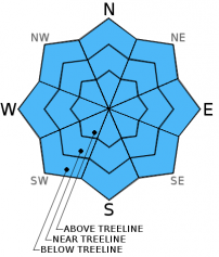
Avalanche danger is LOW for all elevation and aspects. Small isolated areas of loose wet instability will form today in response to daytime heating on slopes 37 degrees and steeper. These areas of instability are not expected to pose a significant hazard to backcountry travelers due to minimal size. Normal caution is advised.

1. Low

?

Above Treeline
Generally safe avalanche conditions. Watch for unstable snow on isolated terrain features.

1. Low

?

Near Treeline
Generally safe avalanche conditions. Watch for unstable snow on isolated terrain features.

1. Low

?

Below Treeline
Generally safe avalanche conditions. Watch for unstable snow on isolated terrain features.
    Generally safe avalanche conditions. Watch for unstable snow on isolated terrain features.
Avalanche Problem 1: Normal Caution
  • Type ?
  • Aspect/Elevation ?
  • Likelihood ?
    Certain
    Very Likely
    Likely
    Possible
    Unlikely
  • Size ?
    Historic
    Very Large
    Large
    Small

Clear skies overnight and near to below freezing air temperatures are expected to have allowed for a strong snow surface refreeze largely due to radiational cooling. Areas of wet snow will form today in response to daytime heating. The deepest wet snow will form on aspects that receive the greatest amount of solar radiation, generally SE-S-SW-W. The NW-N-NE-E aspects that remain somewhat transitional will also experience snow surface melting. Strong rain crust and older melt freeze-crust that extend below the top few inches of the snow surface are expected to keep significant instability from forming today on any aspect. Minor human triggered loose wet instabilities that occur today are expected to remain small and not pose a significant hazard to backcountry travelers without the involvement of cliffs and/or highly defined terrain traps.

recent observations

Observations made yesterday on Rubicon Peak (West Shore Tahoe area) and in High Meadows (north of Freel Peak) revealed transitional snow surface conditions on NW-N-NE-E aspects and well established melt-freeze conditions on SE-S-SW-W aspects. Observed wet snow instabilities during the afternoon hours were minor and inconsequential. Rain crust and melt-freeze crust located a few inches below the snow surface kept conditions ski and boot supportable well into the afternoon hours.

Weather and CURRENT CONDITIONS
weather summary

High pressure continues to build over the region. Sunny skies and above average air temperatures are forecast for today and tomorrow. Ridgetop winds shifted from southwest to east last night and are light to moderate in speed this morning. Winds are forecast to become light today and tonight. Winds will increase to moderate speed out of the southwest tomorrow afternoon in response to a weather system passing to the north of the forecast area. Maximum daytime air temperatures above 7,000' are expected to reach the mid 40s to upper 50s today and tomorrow.

CONDITIONS ALONG THE SIERRA CREST BETWEEN 8200 FT. AND 9200 FT. IN THE LAST 24 HOURS
6am temperature: 30 to 34 deg. F.
Max. temperature: 46 to 49 deg. F.
Average ridgetop wind direction: Southwest shifting to east
Average ridgetop wind speed: 18 mph
Maximum ridgetop wind gust: 32 mph
New snowfall: 0 inches
Total snow depth: 42 to 53 inches
Two-Day Mountain Weather Forecast Produced in partnership with the Reno NWS
For 7000 ft. to 8000 ft.
Saturday Saturday Night Sunday
Weather: Sunny skies. Clear skies. Sunny skies.
Temperatures: 48 to 58 deg. F. 24 to 34 deg. F. 51 to 58 deg. F.
Mid Slope Winds: Variable Variable Southwest
Wind Speed: Light winds Light winds 10 to 15 mph with gusts to 25 mph, increasing to 15 to 25 mph with gusts to 35 mph in the afternoon.
Expected snowfall: 0 0 0
For 8000 ft. to 9000 ft.
Saturday Saturday Night Sunday
Weather: Sunny skies. Clear skies. Sunny skies.
Temperatures: 44 to 54 deg. F. 25 to 35 deg. F. 46 to 56 deg. F.
Ridge Top Winds: Variable Variable Southwest
Wind Speed: Light winds Light winds 15 to 25 mph with gusts to 35 mph, increasing to 20 to 35 mph with gusts to 55 mph in the afternoon.
Expected snowfall: 0 0 0
Disclaimer

This avalanche advisory is provided through a partnership between the Tahoe National Forest and the Sierra Avalanche Center. This advisory covers the Central Sierra Nevada Mountains between Yuba Pass on the north and Ebbetts Pass on the south. Click here for a map of the forecast area. This advisory applies only to backcountry areas outside established ski area boundaries. This advisory describes general avalanche conditions and local variations always occur. This advisory expires 24 hours after the posted time unless otherwise noted. The information in this advisory is provided by the USDA Forest Service who is solely responsible for its content.