THIS AVALANCHE FORECAST EXPIRED ON March 29, 2014 @ 6:56 am
Avalanche Forecast published on March 28, 2014 @ 6:56 am
Issued by Brandon Schwartz - Tahoe National Forest

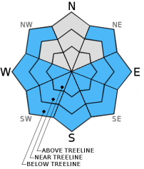
Avalanche danger remains MODERATE on all aspects at all elevations on slopes 35 degrees and steeper due to the presence of established wind slabs and the possibility of loose wet avalanches. Avalanche danger will increase late tonight into tomorrow as the next storm system impacts the region.

2. Moderate

?

Above Treeline
Heightened avalanche conditions on specific terrain features. Evaluate snow and terrain carefully; identify features of concern.

2. Moderate

?

Near Treeline
Heightened avalanche conditions on specific terrain features. Evaluate snow and terrain carefully; identify features of concern.

2. Moderate

?

Below Treeline
Heightened avalanche conditions on specific terrain features. Evaluate snow and terrain carefully; identify features of concern.
    Heightened avalanche conditions on specific terrain features. Evaluate snow and terrain carefully; identify features of concern.
Avalanche Problem 1: Wind Slab
  • Type ?
  • Aspect/Elevation ?
  • Likelihood ?
    Certain
    Very Likely
    Likely
    Possible
    Unlikely
  • Size ?
    Historic
    Very Large
    Large
    Small

Lingering wind slab instability is expected to continue today near treeline and above treeline on NW-N-NE-E aspects on slopes 35 degrees and steeper. Human triggered avalanche activity has been observed over the past two days. Recent wind loading has allowed for wind slabs up to 2+ feet thick to form in lee areas. Time has allowed for some improvement in stability, but difficult to trigger human triggered avalanches remain possible today in recently wind loaded areas. In the more heavily wind loaded areas, avalanche size will easily be large enough to bury or injure a person.

Avalanche Problem 2: Loose Wet
  • Type ?
  • Aspect/Elevation ?
  • Likelihood ?
    Certain
    Very Likely
    Likely
    Possible
    Unlikely
  • Size ?
    Historic
    Very Large
    Large
    Small

During any cloud cover breaks today that allow for periods of sunshine, rapid warming will occur. Natural and human triggered loose wet avalanches will become possible in sun exposed areas on NE-E-SE-S-SW-W-NW aspects. Roller balls initiating from snow falling off of rocks and trees or from human activity could progress to a loose wet avalanche. Involvement of terrain features such as cliffs and terrain traps could greatly increase the consequences of becoming caught in a small loose wet avalanche.

Forecast discussion

Heads up - We are currently tracking a potential developing persistent slab problem. Near crust facets found just below (and sometimes on top of) the melt-freeze crust at the base of the recent storm snow are the weak layer of concern. This layer has been observed to be most well developed and weakest near treeline and below treeline on NW-N-NE aspects. In some areas the associated crust is strong, in other areas it is weak and eroding. The lower elevation limit for this weak layer remains unclear at this time, but thus far it has been noted between 8,500' and 10,000' and may exist as low as 7,500'. In some areas, propagation tests are indicating that fractures are likely to travel through the snowpack once the weak layer is collapsed. At this time there is insufficient snow load to overburden this weak layer. With more storms in the forecast, additional snow loading will further stress this weak layer. Once critical mass is reached, avalanches failing on this weak layer will involve all of the recent storm snow accumulated since March 25th.

recent observations

A skier triggered wind slab avalanche occurred early yesterday morning below Grouse Rocks in the Ward Canyon area. The avalanche occurred on a wind loaded convex slope in near treeline terrain on a NE aspect at 7,900'. The avalanche was approximately 50' wide and ran 150' down slope. The crown was estimated at around 1 foot and the slope angle estimated at 35 degrees. The party had identified this terrain as an area of concern. The caught individual was partially buried and uninjured.

Observations made yesterday on Meiss Ridge (Carson Pass area) and on the East Ridge of Tamarack Peak (Mount Rose backcountry) revealed difficult to trigger but still unstable wind slabs near and above treeline on NW-N-NE aspects. Informal observations revealed skier triggered cracking and recent small avalanches from natural cornice collapse. Formal snowpit tests continued to indicate the possibility of human triggered avalanches failing on lower density layers of recent storm snow below the surface wind slabs.

Observations made yesterday on Rubicon Peak (West Shore Tahoe area) revealed minimal instability associated with wind slabs and storm slabs in the immediate area, but a much more significant potential developing persistent slab problem. Formal snowpit propagation tests targeting the layer of near crust facets just below the crust at the old snow/storm snow interface showed that propagation is likely once the faceted weak layer is collapsed. At this time the overlying snow load is insufficient to overburden this weak layer.

Weather and CURRENT CONDITIONS
weather summary

A shortwave ridge over the forecast area and residual moisture will allow for another day of light snow showers and sun breaks. Snow levels are forecast to rise to around 6,500' to 7,500' today. New snow accumulation is expected to remain limited to a trace. Ridgetop winds remain out of the southwest this morning and are forecast to continue through today at moderate speed. Maximum daytime air temperatures above 7,000' are forecast to reach the mid 30s to low 40s today. Wind speed will increase to gale force tonight as the next storm system impacts the area. This next storm system will bring accumulating snowfall to the forecast area starting late tonight, becoming high intensity at times tomorrow.

CONDITIONS ALONG THE SIERRA CREST BETWEEN 8200 FT. AND 9200 FT. IN THE LAST 24 HOURS
6am temperature: 25 to 28 deg. F.
Max. temperature: 29 to 32 deg. F.
Average ridgetop wind direction: Southwest
Average ridgetop wind speed: 32 mph
Maximum ridgetop wind gust: 50 mph
New snowfall: Trace to 1 inches
Total snow depth: 37 to 54 inches
Two-Day Mountain Weather Forecast Produced in partnership with the Reno NWS
For 7000 ft. to 8000 ft.
Friday Friday Night Saturday
Weather: Mostly cloudy to cloudy skies. Isolated snow showers. Cloudy skies with a chance of snow and rain. Cloudy skies with snow.
Temperatures: 36 to 43 deg. F. 24 to 31 deg. F. 37 to 43 deg. F.
Mid Slope Winds: Southwest Southwest Southwest
Wind Speed: 15 to 25 mph with gusts to 35 mph. 15 to 25 mph with gusts to 40 mph. 20 to 30 mph with gusts to 50 mph.
Expected snowfall: Trace Up to 2 6 to 12
For 8000 ft. to 9000 ft.
Friday Friday Night Saturday
Weather: Mostly cloudy to cloudy skies. Isolated snow showers. Cloudy skies with a chance of snow. Cloudy skies with snow.
Temperatures: 35 to 41 deg. F. 21 to 28 deg. F. 33 to 39 deg. F.
Ridge Top Winds: Southwest Southwest Southwest
Wind Speed: 25 to 35 mph with gusts to 50 mph. 35 to 40 mph with gusts to 65 mph, increasing to 50 to 55 mph with gusts to 85 mph. 45 to 55 mph with gusts to 85 mph.
Expected snowfall: Trace Up to 2 6 to 12
Disclaimer

This avalanche advisory is provided through a partnership between the Tahoe National Forest and the Sierra Avalanche Center. This advisory covers the Central Sierra Nevada Mountains between Yuba Pass on the north and Ebbetts Pass on the south. Click here for a map of the forecast area. This advisory applies only to backcountry areas outside established ski area boundaries. This advisory describes general avalanche conditions and local variations always occur. This advisory expires 24 hours after the posted time unless otherwise noted. The information in this advisory is provided by the USDA Forest Service who is solely responsible for its content.