THIS AVALANCHE FORECAST EXPIRED ON March 31, 2014 @ 7:00 am
Avalanche Forecast published on March 30, 2014 @ 7:00 am
Issued by Andy Anderson - Tahoe National Forest - Sierra Avalanche Center

CONSIDERABLE avalanche danger exists on near and above treeline NW-N-NE-E-SE aspects on slopes 35 degrees and steeper. Human triggered avalanches are likely in these areas. For all other areas avalanche danger is MODERATE on slopes 35 degrees and steeper. Wind slabs, storm slabs, and persistent slabs are all possible today.

3. Considerable

?

Above Treeline
Dangerous avalanche conditions. Careful snowpack evaluation, cautious route-finding and conservative decision-making essential.

3. Considerable

?

Near Treeline
Dangerous avalanche conditions. Careful snowpack evaluation, cautious route-finding and conservative decision-making essential.

2. Moderate

?

Below Treeline
Heightened avalanche conditions on specific terrain features. Evaluate snow and terrain carefully; identify features of concern.
    Dangerous avalanche conditions. Careful snowpack evaluation, cautious route-finding and conservative decision-making essential.
Avalanche Problem 1: Wind Slab
  • Type ?
  • Aspect/Elevation ?
  • Likelihood ?
    Certain
    Very Likely
    Likely
    Possible
    Unlikely
  • Size ?
    Historic
    Very Large
    Large
    Small

Human triggered wind slab avalanches are likely today. The best window for natural wind slab avalanches occurred last night, but some natural wind slab avalanches may remain possible in heavily wind loaded areas today. During the last 24 hours, new snow and southwest winds created wind slabs on the wind-loaded aspects. In exposed near and above treeline terrain, fragile wind slabs 2 to 4 ft in depth could exist on the wind loaded N-NE-E aspects and cross loaded NW and SE aspects. Wind slab avalanches could step down to the older weak layers mentioned below in some cases.

Avalanche Problem 2: Storm Slab
  • Type ?
  • Aspect/Elevation ?
  • Likelihood ?
    Certain
    Very Likely
    Likely
    Possible
    Unlikely
  • Size ?
    Historic
    Very Large
    Large
    Small

Changing conditions during the storm allowed weaknesses to form in the storm snow. As a result of these storm snow weaknesses, human-triggerable storm slabs could exist on any slope with new snow that is not wind affected. These storm slabs should remain less than 2 ft in depth, but if they release they could add enough load to snowpack to cause a failure in the loose weak snow layer under the old crust at the base of the recent snow.

Avalanche Problem 3: Persistent Slab
  • Type ?
  • Aspect/Elevation ?
  • Likelihood ?
    Certain
    Very Likely
    Likely
    Possible
    Unlikely
  • Size ?
    Historic
    Very Large
    Large
    Small

The loose weak layer below the old crusts on the NW-N-NE aspects now has 2-3 ft of snow on top of it in most places. This additional load could bring it close to its breaking point, and human triggered persistent slab avalanches may be possible today. Other larger triggers like the wind slabs or storm slabs mentioned above, cornice failures, or multiple people on a slope are more likely to cause a failure in this layer. This weak layer has been observed in many locations around the forecast area and is most well developed in near treeline and below treeline areas above 8,000' on NW-N-NE aspects. Any avalanches that fail on this weak layer will be large, involving all of the snow accumulated since March 25th. These kind of avalanches can fracture across longer distances and in areas that do not typically slide.

recent observations

Yesterday, observations on northerly aspects on Becker Ridge and in Candy Land (Bear Valley backcountry) showed a thin crust on the snow surface prior to the onset of last night's storm. Below this surface crust, 8-15 inches of recent storm snow existed on top of an older and thicker crust. A layer of loose weak snow (near crust facets) exists just below this older crust in some areas. In the Candy Land area, this weak layer resided on northerly aspects between 7500 and 8500 ft, and tests on this weak layer indicated that if it breaks the resulting crack can propagate along the layer. On Becker Ridge this weak layer was only well developed above 8200 ft, and tests did not reveal any signs of instability associated with this layer. Other observations around the forecast area since 3/27 have shown similar results and variability concerning this weak layer. Data seems to indicate that it is weakest and most well developed on northerly aspects above 8000 ft.

Weather and CURRENT CONDITIONS
weather summary

During the last 24 hours, 10 to 18 inches of snow has fallen across the forecast area. Areas along the Sierra Crest north of Tahoe City received the most snow. Snow showers and the strong southwest winds started to diminish early this morning and should continue to decrease today as the storm system moves out of the area. Light to moderate southwest winds, cold temperatures, and a slight chance of snow showers will persist through tonight in the wake of this storm. By tomorrow a second cold low pressure system approaching the area should bring a chance of snow showers and increased southwest winds back to the area. The main impacts of this system should not arrive till Monday night.

CONDITIONS ALONG THE SIERRA CREST BETWEEN 8200 FT. AND 9200 FT. IN THE LAST 24 HOURS
6am temperature: 17 to 22 deg. F.
Max. temperature: 29 to 35 deg. F.
Average ridgetop wind direction: Southwest
Average ridgetop wind speed: 25 to 35 mph
Maximum ridgetop wind gust: 61 mph
New snowfall: 10 to 17 inches
Total snow depth: 47 to 73 inches
Two-Day Mountain Weather Forecast Produced in partnership with the Reno NWS
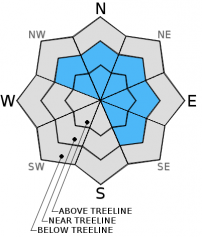
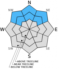
For 7000 ft. to 8000 ft.
Sunday Sunday Night Monday
Weather: Mostly cloudy with a slight chance of snow showers throughout the day Cloudy Cloudy with a slight chance of snow showers in the morning. Snow becoming more likely in the afternoon
Temperatures: 27 to 34 deg. F. 15 to 22 deg. F. 25 to 32 deg. F.
Mid Slope Winds: West Southwest Southwest
Wind Speed: 15 to 20 mph with gusts to 30 mph 10 to 15 mph with gusts to 25 mph 10 to 15 mph with gusts to 25 mph increasing to 20 to 25 mph with gusts to 35 mph in the afternoon
Expected snowfall: 0 0 up to 2
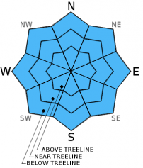
For 8000 ft. to 9000 ft.
Sunday Sunday Night Monday
Weather: Mostly cloudy with a slight chance of snow showers throughout the day Cloudy Cloudy with a slight chance of snow showers in the morning. Snow becoming more likely in the afternoon
Temperatures: 27 to 33 deg. F. 12 to 19 deg. F. 25 to 31 deg. F.
Ridge Top Winds: West Southwest Southwest
Wind Speed: 15 to 20 mph with gusts to 30 mph 15 to 20 mph with gusts to 35 mph 20 to 25 mph with gusts to 35 mph increasing to 35 to 40 mph with gusts to 60 mph in the afternoon
Expected snowfall: 0 0 up to 2
Disclaimer

This avalanche advisory is provided through a partnership between the Tahoe National Forest and the Sierra Avalanche Center. This advisory covers the Central Sierra Nevada Mountains between Yuba Pass on the north and Ebbetts Pass on the south. Click here for a map of the forecast area. This advisory applies only to backcountry areas outside established ski area boundaries. This advisory describes general avalanche conditions and local variations always occur. This advisory expires 24 hours after the posted time unless otherwise noted. The information in this advisory is provided by the USDA Forest Service who is solely responsible for its content.