THIS AVALANCHE FORECAST EXPIRED ON April 2, 2014 @ 7:11 am
Avalanche Forecast published on April 1, 2014 @ 7:11 am
Issued by Andy Anderson - Tahoe National Forest - Sierra Avalanche Center

MODERATE avalanche danger exists at all elevations on NW-N-NE-E-SE aspects on slopes 35 degrees and steeper due to new and old wind slabs, persistent slabs, and storm slabs. Pockets of MODERATE danger exist in all other areas where small storm slabs may also exist. Human triggered avalanches are possible today.

2. Moderate

?

Above Treeline
Heightened avalanche conditions on specific terrain features. Evaluate snow and terrain carefully; identify features of concern.

2. Moderate

?

Near Treeline
Heightened avalanche conditions on specific terrain features. Evaluate snow and terrain carefully; identify features of concern.

2. Moderate

?

Below Treeline
Heightened avalanche conditions on specific terrain features. Evaluate snow and terrain carefully; identify features of concern.
    Heightened avalanche conditions on specific terrain features. Evaluate snow and terrain carefully; identify features of concern.
Avalanche Problem 1: Wind Slab
  • Type ?
  • Aspect/Elevation ?
  • Likelihood ?
    Certain
    Very Likely
    Likely
    Possible
    Unlikely
  • Size ?
    Historic
    Very Large
    Large
    Small

Another round of wind and snow last night means more sensitive wind slabs today. Human triggered wind slab avalanches will be possible in wind loaded areas. Most of these wind slabs should remain less than 3 ft in depth but some larger deeper slabs could exist on heavily wind loaded slopes. Wind loaded N-NE-E aspects and cross loaded NW and SE aspects in near and above treeline terrain represent the best places to find these wind slabs. Avalanches that start as failures of the most recent wind slabs could step down into deeper weaknesses in the snowpack including some lingering weaknesses within the recent snow or the near crust facets below the recent snow on slopes where they exist.

Avalanche Problem 2: Persistent Slab
  • Type ?
  • Aspect/Elevation ?
  • Likelihood ?
    Certain
    Very Likely
    Likely
    Possible
    Unlikely
  • Size ?
    Historic
    Very Large
    Large
    Small

Human triggered persistent slabs will remain possible on the NW-N-NE aspects above 8000 ft. where a loose weak layer of near crust facets exist at the base of the recent snow. Last night's new snow simply added more load above this weak layer. While human triggered persistent slabs are possible today, larger triggers like the wind slabs mentioned above, cornice failures, or multiple people on a slope are even more likely to cause a failure in this layer. Any avalanches that fail on this weak layer will be large, involving all of the snow accumulated since March 25th. These kind of avalanches can fracture across longer distances and in areas that do not typically slide.

Avalanche Problem 3: Storm Slab
  • Type ?
  • Aspect/Elevation ?
  • Likelihood ?
    Certain
    Very Likely
    Likely
    Possible
    Unlikely
  • Size ?
    Historic
    Very Large
    Large
    Small

The storm over the last 24 hours may have allowed small storm slabs to form on non wind affected aspects. Even though most of these should remain relatively small, they could become triggers for the persistent slabs mentioned above. In addition to these small storm slabs some loose dry sluffs involving the new snow may also occur today.

recent observations

Yesterday 3 human triggered avalanches were reported: one on Stevens Peak, one on Scout Peak, and one on Elephant's Back. All were between 1 and 2 ft. in depth and occurred on NE aspects in near or above treeline terrain. On Stevens Peak the slide caught 3 people and buried one of them completely (no injuries were reported). If more details concerning these slides becomes available, we will post them on the observations pages.

Data and observations from N-NE aspects above 8000 ft. on Rubicon Peak and Powderhouse Peak showed that the near crust facets (loose weak snow) buried below the recent snow remain weak. Snowpit tests indicated that fractures can travel along those facets once they break. Ski cuts on small wind loaded test slopes near the summit of Rubicon also resulted in some shooting cracks and small wind slabs failures that measured about 8 to 10 inches in depth.

Weather and CURRENT CONDITIONS
weather summary

Another 6 to 15 inches of new snow fell across the forecast area in the last 24 hours. Most of this snow fell during the night when the main part of this storm arrived. Snow showers and moderate southwest winds should linger around the region today as this system continues to move south. By tonight the winds should shift to the northeast as the system exits the area. The snow showers should continue to decrease tomorrow. The forecast calls for temperatures to remain cold today and tonight with daytime highs in the 20's and overnight lows in the teens. By tomorrow temperatures should start to warm up some with daytime highs forecasted to climb about 5 degrees above today's highs.

CONDITIONS ALONG THE SIERRA CREST BETWEEN 8200 FT. AND 9200 FT. IN THE LAST 24 HOURS
6am temperature: 12 to 13 deg. F.
Max. temperature: 24 to 28 deg. F.
Average ridgetop wind direction: Southwest
Average ridgetop wind speed: 30 mph
Maximum ridgetop wind gust: 47 mph
New snowfall: 6 to 15 inches
Total snow depth: 56 to 86 inches
Two-Day Mountain Weather Forecast Produced in partnership with the Reno NWS
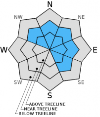
For 7000 ft. to 8000 ft.
Tuesday Tuesday Night Wednesday
Weather: Mostly cloudy with scattered snow showers in the morning. Then snow showers in the afternoon. Mostly cloudy with snow showers likely Mostly cloudy with a chance of snow showers
Temperatures: 24 to 31 deg. F. 12 to 19 deg. F. 29 to 36 deg. F.
Mid Slope Winds: Southwest Variable Northeast
Wind Speed: 15 to 20 mph with gusts to 35 mph in the morning Light 10 to 15 mph in the morning becoming light in the afternoon
Expected snowfall: up to 2 up to 2 0 to 1
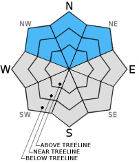
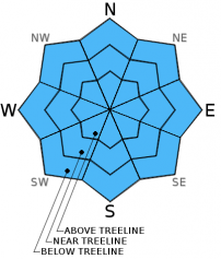
For 8000 ft. to 9000 ft.
Tuesday Tuesday Night Wednesday
Weather: Mostly cloudy with scattered snow showers in the morning. Then snow showers in the afternoon. Mostly cloudy with snow showers likely Mostly cloudy with a chance of snow showers
Temperatures: 23 to 29 deg. F. 9 to 16 deg. F. 28 to 34 deg. F.
Ridge Top Winds: Southwest Southwest shifting to the northeast after midnight Northeast
Wind Speed: 25 to 30 mph with gusts to 50 mph in the morning decreasing to 15 to 20 mph with gusts to 35 mph in the afternoon 10 to 15 mph with gusts to 25 mph 15 to 20 mph with gusts to 30 mph in the morning
Expected snowfall: up to 2 up to 2 0 to 1
Disclaimer

This avalanche advisory is provided through a partnership between the Tahoe National Forest and the Sierra Avalanche Center. This advisory covers the Central Sierra Nevada Mountains between Yuba Pass on the north and Ebbetts Pass on the south. Click here for a map of the forecast area. This advisory applies only to backcountry areas outside established ski area boundaries. This advisory describes general avalanche conditions and local variations always occur. This advisory expires 24 hours after the posted time unless otherwise noted. The information in this advisory is provided by the USDA Forest Service who is solely responsible for its content.