THIS AVALANCHE FORECAST EXPIRED ON April 7, 2014 @ 6:39 am
Avalanche Forecast published on April 6, 2014 @ 6:39 am
Issued by Andy Anderson - Tahoe National Forest - Sierra Avalanche Center

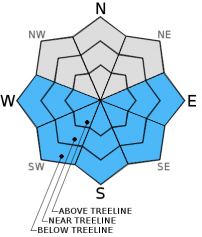
On slopes steeper than 35 degrees MODERATE avalanche danger may form on the sun exposed E-SE-S-SW-W aspects due to daytime warming. Loose wet snow avalanches will be possible today. Larger slab avalanches remain unlikely, but isolated slab avalanches triggered by the today's warming will not be impossible.

2. Moderate

?

Above Treeline
Heightened avalanche conditions on specific terrain features. Evaluate snow and terrain carefully; identify features of concern.

2. Moderate

?

Near Treeline
Heightened avalanche conditions on specific terrain features. Evaluate snow and terrain carefully; identify features of concern.

2. Moderate

?

Below Treeline
Heightened avalanche conditions on specific terrain features. Evaluate snow and terrain carefully; identify features of concern.
    Heightened avalanche conditions on specific terrain features. Evaluate snow and terrain carefully; identify features of concern.
Avalanche Problem 1: Loose Wet
  • Type ?
  • Aspect/Elevation ?
  • Likelihood ?
    Certain
    Very Likely
    Likely
    Possible
    Unlikely
  • Size ?
    Historic
    Very Large
    Large
    Small

More widespread loose wet snow instabilities like roller balls, pinwheels, and loose wet snow sluffs should become possible today due to strong April sunshine, clear skies, and temperatures in the upper 40's and low 50's in the mountains. While the light to moderate northerly winds may slow some of the snowpack warming today, they should not represent enough of a cooling force to prevent these instabilities from forming. Most of these loose wet avalanches should remain too small to bury a person, but they could still push a person into an area with other consequences or could become more serious in areas where terrain traps exist. Larger slab avalanches should still remain unlikely today; however, they are not impossible especially on previously wind loaded SE facing aspects that receive large amounts of sunshine today.

recent observations

Yesterday on the Fireplug, snowpit data, ski cuts on test slopes, hand pits, and general observations did not reveal any signs of lingering instabilities on the northerly aspects. Consistent cloud cover and cool temperatures prevented any wet snow instabilities from forming in this area on the southerly aspects. Soft snow still remained on north aspects sheltered from the sun. NE, NW, and E aspects that received some sun held breakable crusts on the surface. The more sun exposed slopes facing the southern half of the compass held melt-freeze conditions.

Weather and CURRENT CONDITIONS
weather summary

High pressure over the region will bring warm, sunny weather to the area. The forecast calls for daytime highs in the upper 40's and low 50's above 7000 ft. today with temperatures climbing even higher into the mid to upper 50's tomorrow. Some light to moderate northeast winds should continue today. By tomorrow the winds should become light and variable at all elevations. 

CONDITIONS ALONG THE SIERRA CREST BETWEEN 8200 FT. AND 9200 FT. IN THE LAST 24 HOURS
6am temperature: 25 to 32 deg. F.
Max. temperature: 35 to 43 deg. F.
Average ridgetop wind direction: North to east
Average ridgetop wind speed: 10 to 15 mph
Maximum ridgetop wind gust: 39 mph
New snowfall: 0 inches
Total snow depth: 42 to 70 inches
Two-Day Mountain Weather Forecast Produced in partnership with the Reno NWS
For 7000 ft. to 8000 ft.
Sunday Sunday Night Monday
Weather: Sunny Clear Sunny
Temperatures: 46 to 53 deg. F. 26 to 33 deg. F. 52 to 59 deg. F.
Mid Slope Winds: Northeast Northeast Variable
Wind Speed: 10 to 15 mph with gusts to 25 mph 10 to 15 mph Light
Expected snowfall: 0 0 0
For 8000 ft. to 9000 ft.
Sunday Sunday Night Monday
Weather: Sunny Clear Sunny
Temperatures: 44 to 50 deg. F. 27 to 34 deg. F. 51 to 57 deg. F.
Ridge Top Winds: Northeast Northeast Variable
Wind Speed: 15 to 25 mph with gusts to 40 mph 15 to 20 mph with gusts to 30 mph Light
Expected snowfall: 0 0 0
Disclaimer

This avalanche advisory is provided through a partnership between the Tahoe National Forest and the Sierra Avalanche Center. This advisory covers the Central Sierra Nevada Mountains between Yuba Pass on the north and Ebbetts Pass on the south. Click here for a map of the forecast area. This advisory applies only to backcountry areas outside established ski area boundaries. This advisory describes general avalanche conditions and local variations always occur. This advisory expires 24 hours after the posted time unless otherwise noted. The information in this advisory is provided by the USDA Forest Service who is solely responsible for its content.