THIS AVALANCHE FORECAST EXPIRED ON April 10, 2014 @ 6:47 am
Avalanche Forecast published on April 9, 2014 @ 6:47 am
Issued by Brandon Schwartz - Tahoe National Forest

Early this morning, avalanche danger is LOW for all elevations and aspects. Avalanche danger will quickly increase to MODERATE danger by the mid morning hours for all elevations and aspects in response to daytime warming. Small human triggered loose wet avalanches are expected today. Isolated small natural loose wet avalanches are unlikely but not impossible.

2. Moderate

?

Above Treeline
Heightened avalanche conditions on specific terrain features. Evaluate snow and terrain carefully; identify features of concern.

2. Moderate

?

Near Treeline
Heightened avalanche conditions on specific terrain features. Evaluate snow and terrain carefully; identify features of concern.

2. Moderate

?

Below Treeline
Heightened avalanche conditions on specific terrain features. Evaluate snow and terrain carefully; identify features of concern.
    Heightened avalanche conditions on specific terrain features. Evaluate snow and terrain carefully; identify features of concern.
Avalanche Problem 1: Loose Wet
  • Type ?
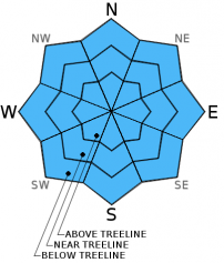
  • Aspect/Elevation ?
  • Likelihood ?
    Certain
    Very Likely
    Likely
    Possible
    Unlikely
  • Size ?
    Historic
    Very Large
    Large
    Small

Overnight minimum air temperatures were well above freezing once again last night and thin high level could cover existed. Snow surface refreeze is expected to be fairly superficial again this morning, having been dependent entirely on weak radiational cooling. A few hours of supportable snow surface conditions are expected early this morning. By mid morning, daytime warming is expected to have caused sufficient snow surface melting to allow for human triggered loose wet avalanches to occur on all aspects.

recent observations

Recent observations from around the forecast area have shown that overnight refreezes have been very superficial with residual wet snow remaining below melt-freeze crust 4 inches thick or less in most areas. Melt-freeze conditions have been noted on all aspects at nearly all elevations. Only the very steep, shaded, higher elevation north aspects have escaped significant melt-freeze and snow surface melting. A report of very minor skier triggered roller balls was received yesterday from Bard's Bowl (Bear Valley backcountry) occurring at 10:25am on an open southeast aspect at 7,900'. In recent days, more significant human triggered, roller ball, pinwheel, and small loose wet avalanches were observed on a variety of aspects between 7,000' and 9,000' by noon.

Weather and CURRENT CONDITIONS
weather summary

High pressure over the region will flatten a bit today as a low pressure system moves through southern Canada. This will allow for a few degrees and cooling, thin high level cloud cover, and moderate speed southwest winds. Another day of well above freezing air temperatures is expected at all elevations. Overnight cooling was slightly better last night with remote sensors between 8,200' and 9,600' reporting overnight minimum air temperatures in the mid 30s to mid 40s. Maximum daytime air temperatures are forecast to once again reach well into the 50s today for areas between 7,000' and 9,000'. Moderate speed ridgetop winds out of the southwest will continue through this evening, becoming light tomorrow.

CONDITIONS ALONG THE SIERRA CREST BETWEEN 8200 FT. AND 9200 FT. IN THE LAST 24 HOURS
6am temperature: 36 to 43 deg. F.
Max. temperature: 52 to 57 deg. F.
Average ridgetop wind direction: Southwest
Average ridgetop wind speed: 22 mph
Maximum ridgetop wind gust: 33 mph
New snowfall: 0 inches
Total snow depth: 41 to 65 inches
Two-Day Mountain Weather Forecast Produced in partnership with the Reno NWS
For 7000 ft. to 8000 ft.
Wednesday Wednesday Night Thursday
Weather: Partly cloudy skies. Partly cloudy skies. Sunny skies.
Temperatures: 55 to 61 deg. F. 28 to 35 deg. F. 53 to 60 deg. F.
Mid Slope Winds: Southwest Southwest Southwest
Wind Speed: 10 to 15 mph with gusts to 25 mph, increasing to 20 to 25 mph with gusts to 35 mph in the afternoon. 20 to 25 mph with gusts to 35 mph in the evening, becoming light. Light winds
Expected snowfall: 0 0 0
For 8000 ft. to 9000 ft.
Wednesday Wednesday Night Thursday
Weather: Partly cloudy skies. Partly cloudy skies. Sunny skies.
Temperatures: 50 to 56 deg. F. 28 to 35 deg. F. 52 to 58 deg. F.
Ridge Top Winds: Southwest Southwest Southwest
Wind Speed: 15 to 25 mph with gusts to 40 mph. 20 to 25 mph with gusts to 40 mph, decreasing to 10 to 15 mph with gusts to 25 mph after midnight. 10 to 15 mph in the morning, becoming light.
Expected snowfall: 0 0 0
Disclaimer

This avalanche advisory is provided through a partnership between the Tahoe National Forest and the Sierra Avalanche Center. This advisory covers the Central Sierra Nevada Mountains between Yuba Pass on the north and Ebbetts Pass on the south. Click here for a map of the forecast area. This advisory applies only to backcountry areas outside established ski area boundaries. This advisory describes general avalanche conditions and local variations always occur. This advisory expires 24 hours after the posted time unless otherwise noted. The information in this advisory is provided by the USDA Forest Service who is solely responsible for its content.