THIS AVALANCHE FORECAST EXPIRED ON April 12, 2014 @ 7:00 am
Avalanche Forecast published on April 11, 2014 @ 7:00 am
Issued by Andy Anderson - Tahoe National Forest - Sierra Avalanche Center

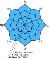
Avalanche danger will quickly rise to MODERATE at all elevations and on all aspects as the day warms up. Human triggered loose wet avalanches are expected today. Natural avalanche activity is unlikely but not impossible.

2. Moderate

?

Above Treeline
Heightened avalanche conditions on specific terrain features. Evaluate snow and terrain carefully; identify features of concern.

2. Moderate

?

Near Treeline
Heightened avalanche conditions on specific terrain features. Evaluate snow and terrain carefully; identify features of concern.

2. Moderate

?

Below Treeline
Heightened avalanche conditions on specific terrain features. Evaluate snow and terrain carefully; identify features of concern.
    Heightened avalanche conditions on specific terrain features. Evaluate snow and terrain carefully; identify features of concern.
Avalanche Problem 1: Loose Wet
  • Type ?
  • Aspect/Elevation ?
  • Likelihood ?
    Certain
    Very Likely
    Likely
    Possible
    Unlikely
  • Size ?
    Historic
    Very Large
    Large
    Small

Some overnight cloud cover and temperatures well above freezing mean that last night's refreeze should have been thin and weak at best. The sunshine and warm temperatures today should quickly melt through this thin refreeze leaving unsupportable wet snow behind. Once this happens the loose wet snow avalanche activity will become possible on all aspects. Most of these loose wet avalanches should remain relatively small, but even small ones can still push a person into an area with other consequences or could become more serious in areas where terrain traps exist. Some larger wet snow instabilities are not impossible especially if the thunderstorms materialize and rain falls on the snowpack.

recent observations

Yesterday on Castle Peak, 30 to 40 cm of wet snow existed on E-SE aspects below 8500 ft. by 10 am. The thin refreeze lasted longer on the SW-W aspects and 3 to 5 cm of soft corn snow existed on top of a thin but supportable refrozen melt-freeze crust on these aspects until at least 11 am. In tree covered areas where the snowpack could not radiate heat out into space the refreeze was either nonexistent or very thin. The snow in these areas remained wet and unsupportable on all aspects. On more open northerly aspects a refrozen surface crust existed above drier snow.

Weather and CURRENT CONDITIONS
weather summary

Some cloud cover formed over the area last night and will persist through the next 36 hours due to a low pressure moving towards southern CA. Daytime highs should remain warm with temperatures above 7000 ft. forecast to climb into the mid to upper 50's and maybe even low 60's for both today and tomorrow. Overnight lows should remain above freezing as well. Warm surface temperatures, cool air aloft, and the presence of some moisture in the atmosphere will create instability that will lead to a 20% chance of afternoon thunderstorms across the forecast area both today and tomorrow. Areas  south of I-80 will have the best potential for thunderstorms, but they could extend northward as well. 

CONDITIONS ALONG THE SIERRA CREST BETWEEN 8200 FT. AND 9200 FT. IN THE LAST 24 HOURS
6am temperature: 33 to 45 deg. F.
Max. temperature: 52 to 59 deg. F.
Average ridgetop wind direction: Southwest
Average ridgetop wind speed: 15 mph
Maximum ridgetop wind gust: 27 mph
New snowfall: 0 inches
Total snow depth: 32 to 60 inches
Two-Day Mountain Weather Forecast Produced in partnership with the Reno NWS
For 7000 ft. to 8000 ft.
Friday Friday Night Saturday
Weather: Partly cloudy becoming mostly cloudy with a slight chance of thunderstorms in the afternoon Mostly cloudy becoming partly cloudy with a slight chance of thunderstorms in the evening and a slight chance of showers after midnight Partly cloudy with a slight chance of showers in the morning and thunderstorms in the afternoon
Temperatures: 53 to 60 deg. F. 30 to 40 deg. F. 53 to 60 deg. F.
Mid Slope Winds: West West West
Wind Speed: 10 to 15 mph in the afternoon 10 to 15 mph in the evening 10 to 15 mph with gusts to 30 mph in the afternoon
Expected snowfall: 0 0 0
For 8000 ft. to 9000 ft.
Friday Friday Night Saturday
Weather: Partly cloudy becoming mostly cloudy with a slight chance of thunderstorms in the afternoon Mostly cloudy becoming partly cloudy with a slight chance of thunderstorms in the evening and a slight chance of showers after midnight Partly cloudy with a slight chance of showers in the morning and thunderstorms in the afternoon
Temperatures: 52 to 58 deg. F. 33 to 42 deg. F. 51 to 57 deg. F.
Ridge Top Winds: West West West
Wind Speed: 10 to 15 mph 10 to 15 mph in the evening 15 to 20 mph with gusts to 35 mph in the afternoon
Expected snowfall: 0 0 0
Disclaimer

This avalanche advisory is provided through a partnership between the Tahoe National Forest and the Sierra Avalanche Center. This advisory covers the Central Sierra Nevada Mountains between Yuba Pass on the north and Ebbetts Pass on the south. Click here for a map of the forecast area. This advisory applies only to backcountry areas outside established ski area boundaries. This advisory describes general avalanche conditions and local variations always occur. This advisory expires 24 hours after the posted time unless otherwise noted. The information in this advisory is provided by the USDA Forest Service who is solely responsible for its content.