THIS AVALANCHE FORECAST EXPIRED ON April 14, 2014 @ 6:44 am
Avalanche Forecast published on April 13, 2014 @ 6:44 am
Issued by Andy Anderson - Tahoe National Forest - Sierra Avalanche Center

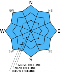
Some pockets of MODERATE avalanche danger may form at all elevations and on all aspects as the day warms up. Due to cooler weather and northeast winds the wet snow instabilities that form today should remain smaller and less widespread than those that have formed on previous days. Still, small human triggered loose wet avalanches will remain possible today in some areas. Natural avalanche activity is unlikely but not impossible.

2. Moderate

?

Above Treeline
Heightened avalanche conditions on specific terrain features. Evaluate snow and terrain carefully; identify features of concern.

2. Moderate

?

Near Treeline
Heightened avalanche conditions on specific terrain features. Evaluate snow and terrain carefully; identify features of concern.

2. Moderate

?

Below Treeline
Heightened avalanche conditions on specific terrain features. Evaluate snow and terrain carefully; identify features of concern.
    Heightened avalanche conditions on specific terrain features. Evaluate snow and terrain carefully; identify features of concern.
Avalanche Problem 1: Loose Wet
  • Type ?
  • Aspect/Elevation ?
  • Likelihood ?
    Certain
    Very Likely
    Likely
    Possible
    Unlikely
  • Size ?
    Historic
    Very Large
    Large
    Small

Clear skies and slightly colder temperatures last night should have allowed a slightly more robust refreeze to occur in most areas. Today's northeast winds and slightly cooler daytime highs should also help this refreeze to last longer. In spite of these cooling factors, the intense sunshine and temperatures in the upper 40's may allow enough melting to occur for some wet snow instabilities including pinwheels, roller balls, and loose wet snow point release avalanches to become possible. Most of these loose wet avalanches should remain small, and they should remain more isolated in distribution today due to the cooler weather and northeast winds. Slopes that experienced weaker refreezes last night will hold the best possibility for wet snow issues today.

recent observations

Yesterday on Becker Peak about 15 cm (6 in) of wet unconsolidated snow existed on top of a supportable melt freeze crust on the sun exposed SE-S-SW aspects. This underlying melt freeze crust remained supportable well into the afternoon on these aspects. On the northerly aspects the snowpack became wet and unsupportable by the afternoon and stepping off of one's skis resulted in sinking thigh deep into wet snow. Farther north on Incline Lake Peak the supportable melt freeze crust melted away by noon leaving shin deep wet snow on all aspects. Ski cuts on steep test slopes triggered small roller balls, pinwheels, and some wet snow sluffs in this area by 12:30 pm. 

Weather and CURRENT CONDITIONS
weather summary

Temperatures last night dropped into the mid to upper 30's according to most of the remote sensors above 7500 ft, and the winds shifted to the northeast early this morning. Today's forecast calls for continued cool east and northeast winds and slightly colder daytime highs. Temperatures should top out in the mid to upper 40's today above 7000 ft. instead of the mid to upper 50's. This slightly colder weather should start to warm back up by tomorrow and the wind should shift back to the southwest and decrease. 

CONDITIONS ALONG THE SIERRA CREST BETWEEN 8200 FT. AND 9200 FT. IN THE LAST 24 HOURS
6am temperature: 31 to 43 deg. F.
Max. temperature: 47 to 54 deg. F.
Average ridgetop wind direction: Southwest shifting to the northeast early this morning
Average ridgetop wind speed: 20 mph
Maximum ridgetop wind gust: 42 mph
New snowfall: 0 inches
Total snow depth: 28 to 57 inches
Two-Day Mountain Weather Forecast Produced in partnership with the Reno NWS
For 7000 ft. to 8000 ft.
Sunday Sunday Night Monday
Weather: Sunny Clear Sunny
Temperatures: 44 to 51 deg. F. 25 to 32 deg. F. 52 to 59 deg. F.
Mid Slope Winds: Northeast East Southwest
Wind Speed: 15 to 25 mph with gusts to 30 mph increasing to 40 mph in the afternoon 15 to 20 mph with gusts to 35 mph 10 to 15 mph in the afternoon
Expected snowfall: 0 0 0
For 8000 ft. to 9000 ft.
Sunday Sunday Night Monday
Weather: Sunny Clear Sunny
Temperatures: 40 to 47 deg. F. 26 to 33 deg. F. 46 to 53 deg. F.
Ridge Top Winds: Northeast East Southwest
Wind Speed: 25 to 35 mph with gusts to 55 mph 15 to 25 mph with gusts to 40 mph 10 to 15 mph with gusts to 25 mph in the afternoon
Expected snowfall: 0 0 0
Disclaimer

This avalanche advisory is provided through a partnership between the Tahoe National Forest and the Sierra Avalanche Center. This advisory covers the Central Sierra Nevada Mountains between Yuba Pass on the north and Ebbetts Pass on the south. Click here for a map of the forecast area. This advisory applies only to backcountry areas outside established ski area boundaries. This advisory describes general avalanche conditions and local variations always occur. This advisory expires 24 hours after the posted time unless otherwise noted. The information in this advisory is provided by the USDA Forest Service who is solely responsible for its content.