THIS AVALANCHE FORECAST EXPIRED ON April 17, 2014 @ 6:48 am
Avalanche Forecast published on April 16, 2014 @ 6:48 am
Issued by Brandon Schwartz - Tahoe National Forest

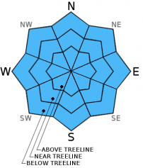
Early this morning, avalanche danger is LOW for all elevations and aspects. Areas of MODERATE danger will form as the day progresses on all aspects at all elevations on slopes 37 degrees and steeper. Human triggered loose wet avalanches will become possible. Natural avalanches remain unlikely.

2. Moderate

?

Above Treeline
Heightened avalanche conditions on specific terrain features. Evaluate snow and terrain carefully; identify features of concern.

2. Moderate

?

Near Treeline
Heightened avalanche conditions on specific terrain features. Evaluate snow and terrain carefully; identify features of concern.

2. Moderate

?

Below Treeline
Heightened avalanche conditions on specific terrain features. Evaluate snow and terrain carefully; identify features of concern.
    Heightened avalanche conditions on specific terrain features. Evaluate snow and terrain carefully; identify features of concern.
Avalanche Problem 1: Loose Wet
  • Type ?
  • Aspect/Elevation ?
  • Likelihood ?
    Certain
    Very Likely
    Likely
    Possible
    Unlikely
  • Size ?
    Historic
    Very Large
    Large
    Small

A decent snow surface refreeze is expected to have occurred last night due to radiational cooling under clear skies, despite above freezing air temperatures. As daytime warming progresses, snow surface melt will allow for human triggered loose wet avalanches to become possible on all aspects at all elevations. Any avalanches that occur today are expected to be small. Once last night's snow surface refreeze is fully melted and the snowpack becomes unsupportable, move to more northerly aspects or exit from in or below avalanche terrain for the remainder of the day.

recent observations

Observations made yesterday on Tamarack Peak (Mount Rose backcountry) revealed a fairly thin overnight snow surface refreeze and evidence of a rapidly melting snowpack. By 10:45 am, E aspect areas at around 9,650' were becoming marginally skier supportable. Probing of the snowpack depth at the site of the snowpit dug on April 9th on an E aspect at 9,760' revealed that the snowpack had decreased by 18 inches over the previous 6 days. Surrounding areas of SE-S aspects on Rose Knob Peak and Incline Lake Peak had rapidly melted out to bare ground during that time period. Mount Houghton appeared to be one of the few surrounding areas holding continuous snow cover on SE-S aspects, isolated to the 9,400 to 10,500' elevation range.

Weather and CURRENT CONDITIONS
weather summary

Short lived high pressure will build over the forecast area today ahead of another cold front disturbance expected to pass through the forecast area late Thursday into Friday. For today sunny skies, decreasing winds, and yet another round of above average air temperatures are forecast. Remote sensors between 8,200' and 8,900' are reporting overnight low air temperatures in the mid to upper 30s under clear skies. Maximum daytime air temperatures above 7,000' are forecast to reach the upper 40s to upper 50s today. Ridgetop winds are decreasing to light in speed this morning and have shifted to the north. Light winds are expected to continue until tomorrow afternoon before increasing to moderate speed out of the southwest ahead of the approaching cold front.

CONDITIONS ALONG THE SIERRA CREST BETWEEN 8200 FT. AND 9200 FT. IN THE LAST 24 HOURS
6am temperature: 35 to 39 deg. F.
Max. temperature: 50 to 53 deg. F.
Average ridgetop wind direction: Southwest
Average ridgetop wind speed: 25 mph
Maximum ridgetop wind gust: 44 mph
New snowfall: 0 inches
Total snow depth: 20 to 53 inches
Two-Day Mountain Weather Forecast Produced in partnership with the Reno NWS
For 7000 ft. to 8000 ft.
Wednesday Wednesday Night Thursday
Weather: Mostly sunny skies. Clear skies. Sunny skies, becoming partly cloudy.
Temperatures: 53 to 60 deg. F. 34 to 39 deg. F. 56 to 62 deg. F.
Mid Slope Winds: North Variable Southwest
Wind Speed: Around 10 mph in the morning, becoming light. Light winds Light winds increasing to 10 to 15 mph with gusts to 25 mph in the afternoon.
Expected snowfall: 0 0 0
For 8000 ft. to 9000 ft.
Wednesday Wednesday Night Thursday
Weather: Mostly sunny skies. Clear skies. Sunny skies, becoming partly cloudy.
Temperatures: 47 to 54 deg. F. 32 to 37 deg. F. 48 to 55 deg. F.
Ridge Top Winds: Northwest Northwest shifting to southeast after midnight. South shifting to southwest.
Wind Speed: 15 to 20 mph in the morning, decreasing to around 10 mph. Around 10 mph. 10 to 15 mph in the morning, increasing to 15 to 20 mph with gusts to 30 mph in the afternoon.
Expected snowfall: 0 0 0
Disclaimer

This avalanche advisory is provided through a partnership between the Tahoe National Forest and the Sierra Avalanche Center. This advisory covers the Central Sierra Nevada Mountains between Yuba Pass on the north and Ebbetts Pass on the south. Click here for a map of the forecast area. This advisory applies only to backcountry areas outside established ski area boundaries. This advisory describes general avalanche conditions and local variations always occur. This advisory expires 24 hours after the posted time unless otherwise noted. The information in this advisory is provided by the USDA Forest Service who is solely responsible for its content.