THIS AVALANCHE FORECAST EXPIRED ON April 18, 2014 @ 6:36 am
Avalanche Forecast published on April 17, 2014 @ 6:36 am
Issued by Andy Anderson - Tahoe National Forest - Sierra Avalanche Center

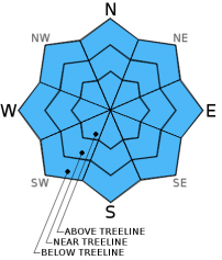
Areas of MODERATE danger will form on all aspects at all elevations on slopes 37 degrees and steeper as daytime warming and sunshine melt through the thin overnight refreeze holding the snowpack together. Human triggered loose wet avalanches will become possible. Natural avalanches remain unlikely but not impossible.

2. Moderate

?

Above Treeline
Heightened avalanche conditions on specific terrain features. Evaluate snow and terrain carefully; identify features of concern.

2. Moderate

?

Near Treeline
Heightened avalanche conditions on specific terrain features. Evaluate snow and terrain carefully; identify features of concern.

2. Moderate

?

Below Treeline
Heightened avalanche conditions on specific terrain features. Evaluate snow and terrain carefully; identify features of concern.
    Heightened avalanche conditions on specific terrain features. Evaluate snow and terrain carefully; identify features of concern.
Avalanche Problem 1: Loose Wet
  • Type ?
  • Aspect/Elevation ?
  • Likelihood ?
    Certain
    Very Likely
    Likely
    Possible
    Unlikely
  • Size ?
    Historic
    Very Large
    Large
    Small

Clear skies last night should have allow the snow to radiate enough heat out into the night for a thin refreeze to have occurred even though temperatures stayed well above freezing. This thin refreeze will melt quickly as the strong April sunshine hits the slopes and daytime temperatures rise towards the mid to upper 50's above 7000 ft. Once the refreeze melts enough unconsolidated wet snow will exist for human triggered loose wet avalanches including pinwheels, roller balls, and loose wet snow point release avalanches to become possible on all aspects at all elevations. Most of these loose wet avalanches should remain small. Getting out early and leaving the slopes before last night's refreeze completely melts represents a good way to avoid dealing with unsupportable wet snow. Once the refreeze does melt the recreation conditions deteriorate and the avalanche hazard increases. At that point finding a different afternoon activity that does not involve steep snow covered slopes is a great idea.

recent observations

Observations continue to show a snowpack consisting mostly of melt-freeze conditions on all aspects. Each day the snowpack has become unsupportable wet snow once the overnight refreeze melts. Yesterday on Andesite Peak this change occurred in a span of 20 minutes around 11 am. The supportable crust topped with 2 to 3 cm of wet snow quickly became deep wet snow with ski pen to 20 cm at that time. In areas where the snowpack cannot radiate heat out into the night sky (like tree covered areas) little to no refreeze occurred.

Weather and CURRENT CONDITIONS
weather summary

The wind should shift to the southwest and increase this afternoon and some cloud cover could start to form as a weak front approaches the area. This front combined with a small low pressure moving into southern CA should allow slightly cooler temperatures and increased cloud cover tonight and tomorrow. The forecast calls for a slight (20%) chance of isolated showers tomorrow with some thunderstorms possible by the afternoon.  

CONDITIONS ALONG THE SIERRA CREST BETWEEN 8200 FT. AND 9200 FT. IN THE LAST 24 HOURS
6am temperature: 36 to 45 deg. F.
Max. temperature: 52 to 56 deg. F.
Average ridgetop wind direction: Southwest to southeast
Average ridgetop wind speed: 10 to 15 mph
Maximum ridgetop wind gust: 26 mph
New snowfall: 0 inches
Total snow depth: 20 to 53 inches
Two-Day Mountain Weather Forecast Produced in partnership with the Reno NWS
For 7000 ft. to 8000 ft.
Thursday Thursday Night Friday
Weather: Sunny becoming partly cloudy during the day Mostly cloudy Mostly cloudy with a 20% chance of isolated showers and thunderstorms in the afternoon
Temperatures: 56 to 62 deg. F. 33 to 38 deg. F. 49 to 56 deg. F.
Mid Slope Winds: South shifting to the southwest in the afternoon Southwest Southwest
Wind Speed: 5 to 10 mph increasing to 10 to 20 mph with gusts to 30 mph in the afternoon 15 to 20 mph with gusts to 35 mph 10 to 15 mph decreasing in the afternoon
Expected snowfall: 0 0 0
For 8000 ft. to 9000 ft.
Thursday Thursday Night Friday
Weather: Sunny becoming partly cloudy during the day Mostly cloudy Mostly cloudy with a 20% chance of isolated showers and thunderstorms in the afternoon
Temperatures: 48 to 56 deg. F. 27 to 34 deg. F. 43 to 50 deg. F.
Ridge Top Winds: South shifting to the southwest in the afternoon Southwest Southwest
Wind Speed: 10 to 15 mph increasing to 15 to 25 mph with gusts to 40 mph in the afternoon 25 to 35 mph with gusts to 45 mph 15 to 20 mph with gusts to 30 mph decreasing in the afternoon
Expected snowfall: 0 0 0
Disclaimer

This avalanche advisory is provided through a partnership between the Tahoe National Forest and the Sierra Avalanche Center. This advisory covers the Central Sierra Nevada Mountains between Yuba Pass on the north and Ebbetts Pass on the south. Click here for a map of the forecast area. This advisory applies only to backcountry areas outside established ski area boundaries. This advisory describes general avalanche conditions and local variations always occur. This advisory expires 24 hours after the posted time unless otherwise noted. The information in this advisory is provided by the USDA Forest Service who is solely responsible for its content.