THIS AVALANCHE FORECAST EXPIRED ON April 20, 2014 @ 6:47 am
Avalanche Forecast published on April 19, 2014 @ 6:47 am
Issued by Andy Anderson - Tahoe National Forest - Sierra Avalanche Center

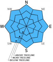
MODERATE danger will form on all aspects at all elevations on slopes 37 degrees and steeper as daytime warming and sunshine melt through the overnight refreeze holding the snowpack together. Human triggered loose wet avalanches will become possible. Natural avalanches remain unlikely.

2. Moderate

?

Above Treeline
Heightened avalanche conditions on specific terrain features. Evaluate snow and terrain carefully; identify features of concern.

2. Moderate

?

Near Treeline
Heightened avalanche conditions on specific terrain features. Evaluate snow and terrain carefully; identify features of concern.

2. Moderate

?

Below Treeline
Heightened avalanche conditions on specific terrain features. Evaluate snow and terrain carefully; identify features of concern.
    Heightened avalanche conditions on specific terrain features. Evaluate snow and terrain carefully; identify features of concern.
Avalanche Problem 1: Loose Wet
  • Type ?
  • Aspect/Elevation ?
  • Likelihood ?
    Certain
    Very Likely
    Likely
    Possible
    Unlikely
  • Size ?
    Historic
    Very Large
    Large
    Small

Last night's scattered cloud cover should have prevented a strong refreeze in some areas even though temperatures did remain slightly cooler. In areas where the clouds cleared a stronger overnight refreeze should have occurred. In either case, today's strong sunshine and warm temperatures should still melt through the refreeze. The areas with a weak refreeze will become unsupportable sooner, and those with the stronger refreeze will last a little longer. Once the refreeze melts, enough unconsolidated wet snow will exist for human triggered loose wet avalanches including pinwheels, roller balls, and loose wet snow point release avalanches to become possible on all aspects at all elevations. Most of these loose wet snow instabilities should remain small and not entrain much snow.

Getting out early and leaving the slopes before last night's refreeze completely melts represents a good way to avoid dealing with unsupportable, wet, sticky snow. Once the refreeze does melt the recreation conditions deteriorate and the hazards increase. At that point finding a different afternoon activity that does not involve steep snow covered slopes is a great idea.

recent observations

Yesterday on Castle Peak, the refreeze lasted a little longer than on previous days and provided a slightly longer window when the snowpack remained supportable. The sun and warm spring weather did melt through the refreeze by about 12:30, leaving boot-top deep wet snow behind on the E-SE-S-SW aspects. The northerly aspects that held firm frozen surface crusts in the morning stayed supportable for a little while longer. Large areas of bare ground have melted out along the west ridge and on the SE-S-SW aspects.

Weather and CURRENT CONDITIONS
weather summary

A small ridge building over the west coast will bring mostly sunny skies and warmer temperatures back to the forecast area through the weekend. The forecast calls for daytime highs in the mid to upper 50's in the mountains with some areas even reaching into the low 60's in the 7000-8000 ft. range. Some isolated and scattered clouds may linger over the region through tomorrow.

CONDITIONS ALONG THE SIERRA CREST BETWEEN 8200 FT. AND 9200 FT. IN THE LAST 24 HOURS
6am temperature: 33 to 40 deg. F.
Max. temperature: 50 to 54 deg. F.
Average ridgetop wind direction: Southwest
Average ridgetop wind speed: 10 to 15 mph
Maximum ridgetop wind gust: 48 mph
New snowfall: 0 inches
Total snow depth: 16 to 51 inches
Two-Day Mountain Weather Forecast Produced in partnership with the Reno NWS
For 7000 ft. to 8000 ft.
Saturday Saturday Night Sunday
Weather: Partly cloudy to mostly sunny Partly cloudy Partly cloudy
Temperatures: 54 to 63 deg. F. 30 to 40 deg. F. 54 to 63 deg. F.
Mid Slope Winds: Southwest West Variable
Wind Speed: Light winds increasing to 10 to 20 mph in the afternoon 10 to 15 mph with gusts to 25 mph decreasing after midnight Light
Expected snowfall: 0 0 0
For 8000 ft. to 9000 ft.
Saturday Saturday Night Sunday
Weather: Partly cloudy to mostly sunny Partly cloudy Partly cloudy
Temperatures: 46 to 56 deg. F. 30 to 38 deg. F. 48 to 58 deg. F.
Ridge Top Winds: Southwest West Variable
Wind Speed: 15 to 20 mph with gusts to 30 mph in the afternoon 10 to 15 mph with gusts to 25 mph in the evening Light
Expected snowfall: 0 0 0
Disclaimer

This avalanche advisory is provided through a partnership between the Tahoe National Forest and the Sierra Avalanche Center. This advisory covers the Central Sierra Nevada Mountains between Yuba Pass on the north and Ebbetts Pass on the south. Click here for a map of the forecast area. This advisory applies only to backcountry areas outside established ski area boundaries. This advisory describes general avalanche conditions and local variations always occur. This advisory expires 24 hours after the posted time unless otherwise noted. The information in this advisory is provided by the USDA Forest Service who is solely responsible for its content.