THIS AVALANCHE FORECAST EXPIRED ON December 26, 2014 @ 6:40 am
Avalanche Forecast published on December 25, 2014 @ 6:40 am
Issued by Andy Anderson - Tahoe National Forest - Sierra Avalanche Center

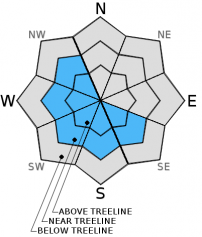
SE-S-SW-W-NW aspects loaded by the NE winds in near and above treeline terrain may hold some pockets of MODERATE avalanche danger on slopes 35 degrees and steeper. These pockets of higher avalanche danger will most likely exist on slopes that had previous snow cover near ridgelines where the most new snow fell. Human-triggered wind slab avalanches may be possible in these areas.

2. Moderate

?

Above Treeline
Heightened avalanche conditions on specific terrain features. Evaluate snow and terrain carefully; identify features of concern.

2. Moderate

?

Near Treeline
Heightened avalanche conditions on specific terrain features. Evaluate snow and terrain carefully; identify features of concern.

1. Low

?

Below Treeline
Generally safe avalanche conditions. Watch for unstable snow on isolated terrain features.
    Heightened avalanche conditions on specific terrain features. Evaluate snow and terrain carefully; identify features of concern.
Avalanche Problem 1: Wind Slab
  • Type ?
  • Aspect/Elevation ?
  • Likelihood ?
    Certain
    Very Likely
    Likely
    Possible
    Unlikely
  • Size ?
    Historic
    Very Large
    Large
    Small

The winds shifted to the north and east last night and have remained strong enough to redistribute the new snow that fell yesterday afternoon and evening. These winds have scoured the traditionally wind loaded aspects and deposited new wind slabs on top of frozen crusts on some of the SE-S-SW-W-NW aspects. Human triggered avalanches involving these wind slabs will be possible today. Most of these wind slabs should remain limited to areas near ridgelines, remain relatively small, and should not extend very far down slope due to the limited amount of snow available for transport. However, some larger wind slabs may exist in the most heavily wind loaded areas and in areas that received more new snow.

Snow conditions today will be a mix of scoured frozen crusts, dust on crust, and wind slabs depending on aspect, elevation, and exposure.

recent observations

Yesterday on Andesite Ridge new snow started to fall around 2pm and deposited a layer of graupel (ball bearing shaped snow) on top of the frozen crusts that existed on all aspects. This crust varied from supportable to breakable in the Andesite area. Snowpit data started to hint at a possible weak layer forming just below the frozen rain crust on northerly aspects.

Weather and CURRENT CONDITIONS
weather summary

The cold front moved through the area faster than expected yesterday, and snowfall ended earlier than expected leaving only 2 to 6 inches of new snow in the mountains. The winds shifted to the north and east behind the cold front at about 7pm last night. 25 to 35 mph northeast winds should continue through tomorrow along exposed ridgelines and in exposed upper elevation areas. Skies started to clear overnight, and the forecast calls for partly cloudy to partly sunny skies today. By tomorrow the forecast area should experience sunny skies. Cold air left behind by the cold front will keep temperatures in the teens and 20's above 7000 ft. today and tomorrow with overnight lows in the single digits.

CONDITIONS ALONG THE SIERRA CREST BETWEEN 8200 FT. AND 9200 FT. IN THE LAST 24 HOURS
6am temperature: 10 to 16 deg. F.
Max. temperature: 35 to 43 deg. F.
Average ridgetop wind direction: Southwest shifting to Northeast after 7pm yesterday
Average ridgetop wind speed: 35 to 45 mph
Maximum ridgetop wind gust: 120 mph
New snowfall: 2 to 6 inches
Total snow depth: 26 to 39 inches
Two-Day Mountain Weather Forecast Produced in partnership with the Reno NWS
For 7000 ft. to 8000 ft.
Thursday Thursday Night Friday
Weather: Partly cloudy Partly cloudy becoming clear overnight Sunny
Temperatures: 21 to 26 deg. F. 9 to 14 deg. F. 23 to 28 deg. F.
Mid Slope Winds: Northeast East East
Wind Speed: 10 to 20 mph with gusts to 30 mph 15 to 25 mph with gusts to 35 mph 15 to 25 mph with gusts to 35 mph decreasing to 10 to 20 mph with gusts to 30 mph in the afternoon
Expected snowfall: 0 0 0
For 8000 ft. to 9000 ft.
Thursday Thursday Night Friday
Weather: Partly cloudy Partly cloudy becoming clear overnight Sunny
Temperatures: 14 to 21 deg. F. 6 to 13 deg. F. 17 to 23 deg. F.
Ridge Top Winds: Northeast Northeast Northeast
Wind Speed: 20 to 30 mph with gusts to 45 mph 25 to 35 mph with gusts to 50 mph 25 to 35 mph with gusts to 50 mph
Expected snowfall: 0 0 0
Disclaimer

This avalanche advisory is provided through a partnership between the Tahoe National Forest and the Sierra Avalanche Center. This advisory covers the Central Sierra Nevada Mountains between Yuba Pass on the north and Ebbetts Pass on the south. Click here for a map of the forecast area. This advisory applies only to backcountry areas outside established ski area boundaries. This advisory describes general avalanche conditions and local variations always occur. This advisory expires 24 hours after the posted time unless otherwise noted. The information in this advisory is provided by the USDA Forest Service who is solely responsible for its content.