THIS AVALANCHE FORECAST EXPIRED ON December 27, 2014 @ 7:00 am
Avalanche Forecast published on December 26, 2014 @ 7:00 am
Issued by Brandon Schwartz - Tahoe National Forest

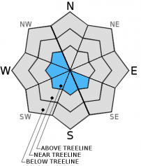
LOW avalanche danger exists for all elevations and aspects. Human triggered avalanches are unlikely, but far from impossible today. Isolated pockets of small, shallow, unstable wind slab may exist above treeline on SE-S-SW-W-NW aspects due to recent areas of blowing snow.

1. Low

?

Above Treeline
Generally safe avalanche conditions. Watch for unstable snow on isolated terrain features.

1. Low

?

Near Treeline
Generally safe avalanche conditions. Watch for unstable snow on isolated terrain features.

1. Low

?

Below Treeline
Generally safe avalanche conditions. Watch for unstable snow on isolated terrain features.
    Generally safe avalanche conditions. Watch for unstable snow on isolated terrain features.
Avalanche Problem 1: Wind Slab
  • Type ?
  • Aspect/Elevation ?
  • Likelihood ?
    Certain
    Very Likely
    Likely
    Possible
    Unlikely
  • Size ?
    Historic
    Very Large
    Large
    Small

Strong NE winds have redistributed the few inches of recent strom snow that were available for wind transport. Small shallow wind slabs exist in recently wind loaded areas, mainly above treeline on SE-S-SW-W-NW aspects. Recent observations indicate that human triggered avalanches are unlikely, but far from impossible today. Isolated instability may exist on specific complex terrain features including couloirs and gullies.

recent observations

Observations made yesterday on Carson Pass revealed areas of blowing snow in above treeline terrain. With most of the snowpack capped by the high elevation rain/melt-freeze crust that formed following the Dec 20-21 warming event, loose snow available for transport was limited to the 2 to 6 inches of Dec 24 storm snow. Strong NE winds were noted to carry snow significant distances past ridgetops, leading to irregular and uneven redistribution of snow on the ground. On Red Lake Peak, wind slabs 6 to 8 inches deep were observed to have formed in small pockets near terrain irregulairities. Hand shears on several wind loaded aspects revealed smooth failure planes within the wind loaded snow. However, ski cuts on wind loaded SW aspect terrain features did not produce propagating fractures.

Weather and CURRENT CONDITIONS
weather summary

Below average air temperatures, northeast winds, and sunny skies are forecast for today. Remote sensors in the 8,000' to 9,000' range are reporting air temperatures this morning in the single digits to mid teens. Maximum daytime air temperatures are forecast to reach the upper teens to mid 20s today for areas above 7,000'. Ridgetop winds remain out of the northeast this morning and are expected to remain moderate to strong in speed. Warmer air temperatures and decreasing winds are expected tomorrow.

CONDITIONS ALONG THE SIERRA CREST BETWEEN 8200 FT. AND 9200 FT. IN THE LAST 24 HOURS
6am temperature: 7 to 14 deg. F.
Max. temperature: 13 to 21 deg. F.
Average ridgetop wind direction: Northeast
Average ridgetop wind speed: 36 mph
Maximum ridgetop wind gust: 69 mph
New snowfall: 0 to trace inches
Total snow depth: 26 to 39 inches
Two-Day Mountain Weather Forecast Produced in partnership with the Reno NWS
For 7000 ft. to 8000 ft.
Friday Friday Night Saturday
Weather: Sunny skies. Clear skies. Sunny skies.
Temperatures: 20 to 27 deg. F. 10 to 15 deg. F. 30 to 35 deg. F.
Mid Slope Winds: E E E
Wind Speed: 15 to 25 mph with gusts to 35 mph, decreasing to 10 to 20 mph in the afternoon. 10 to 20 mph with gusts to 30 mph. Light winds.
Expected snowfall: 0 0 0
For 8000 ft. to 9000 ft.
Friday Friday Night Saturday
Weather: Sunny skies. Clear skies. Sunny skies.
Temperatures: 17 to 24 deg. F. 9 to 16 deg. F. 29 to 34 deg. F.
Ridge Top Winds: NE E E shifting to W in the afternoon.
Wind Speed: 20 to 35 mph with gusts to 55 mph. 20 to 30 mph with gusts to 45 mph. 10 to 15 mph.
Expected snowfall: 0 0 0
Disclaimer

This avalanche advisory is provided through a partnership between the Tahoe National Forest and the Sierra Avalanche Center. This advisory covers the Central Sierra Nevada Mountains between Yuba Pass on the north and Ebbetts Pass on the south. Click here for a map of the forecast area. This advisory applies only to backcountry areas outside established ski area boundaries. This advisory describes general avalanche conditions and local variations always occur. This advisory expires 24 hours after the posted time unless otherwise noted. The information in this advisory is provided by the USDA Forest Service who is solely responsible for its content.