THIS AVALANCHE FORECAST EXPIRED ON December 4, 2014 @ 6:55 am
Avalanche Forecast published on December 3, 2014 @ 6:55 am
Issued by Brandon Schwartz - Tahoe National Forest

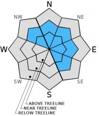
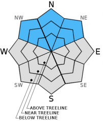
Above 8,000', areas of CONSIDERABLE avalanche danger exist both above and below treeline on NW-N-NE-E-SE aspects on slopes 32 degrees and steeper. For all other areas, avalanche danger is MODERATE on slopes 35 degrees and steeper. Wind slabs and persistent slabs can be found in a variety of areas. Natural avalanches are possible, human triggered avalanches are possible to likely.

3. Considerable

?

Above Treeline
Dangerous avalanche conditions. Careful snowpack evaluation, cautious route-finding and conservative decision-making essential.

3. Considerable

?

Near Treeline
Dangerous avalanche conditions. Careful snowpack evaluation, cautious route-finding and conservative decision-making essential.

3. Considerable

?

Below Treeline
Dangerous avalanche conditions. Careful snowpack evaluation, cautious route-finding and conservative decision-making essential.
    Dangerous avalanche conditions. Careful snowpack evaluation, cautious route-finding and conservative decision-making essential.
Avalanche Problem 1: Wind Slab
  • Type ?
  • Aspect/Elevation ?
  • Likelihood ?
    Certain
    Very Likely
    Likely
    Possible
    Unlikely
  • Size ?
    Historic
    Very Large
    Large
    Small

Wind and new snow above 7,500' have combined to create wind slabs in near treeline and above treeline terrain on NW-N-NE-E-SE aspects. These wind slabs will continue to increase in size today. Human triggered wind slab avalanches large enough to bury or injure a person are possible to likely today.

Avalanche Problem 2: Persistent Slab
  • Type ?
  • Aspect/Elevation ?
  • Likelihood ?
    Certain
    Very Likely
    Likely
    Possible
    Unlikely
  • Size ?
    Historic
    Very Large
    Large
    Small

Early season snowfall starting back in October allowed shallow snow cover to persist on northerly aspects above 8,000' to 9,000'. These weak layers are now experiencing rapid loading and increasing stress. The areas where the most snow existed prior to the onset of the current storm are now the most dangerous. Here in lies the issue as these same areas are the most inviting for skiing and riding today. Slope cuts and previous tracks are not reliable indications of stability when dealing with persistent slabs. The only mitigation option is terrain and/or snowpack avoidance. Either choose slopes less than 32 degrees in slope angle without steeper terrain above or avoid areas where the weak layer exists. Consciously making these types of slope scale terrain and snowpack decisions are the difference between "getting lucky" and "getting it done" in the backcountry.

recent observations

The first reported avalanche of the season occurred Dec 1 in the Carson Pass area near Round Top Peak in a NNE aspect couloir at 9,800'. The triggering snowboarder was caught, carried, and managed to avoid burial or injury. Based on the report received, the suspected avalanche type is wind slab. More info is available here. Wind slabs that existed on Dec 1 prior to the onset of the current storm cycle have become larger and thicker over the past 24 hours.

Recent observations from around the forecast area have shown the presence of weak, loose grained basal facets (sugar snow) on most NW-N-NE aspects above 8,000' along the Sierra Crest and above 9,000' in the Carson Range. Snowpit tests, including those performed yesterday on Tamarack Peak (Mount Rose area) indicate that these basal facets are in poor condition to handle new snow loading. These facets will be the weak layer for persistent slab problems that exist today.

Weather and CURRENT CONDITIONS
weather summary

The second wave of the current storm system will move through the forecast area today. Another round of high intensity precipitation is expected today with snow levels around 7,000' to 7,500'. Over the past 24 hours, cold pools of air allowed snow level to drop as low as 4,700'. The lower atmosphere has now mixed and snow levels are not expected to drop below 6,500'. New snow amounts at 8,000' range from 6 to 12 inches with some pockets of greater accumulation above 9,500'. Strong SW winds over the past 24 hours are expected to continue through tonight.

CONDITIONS ALONG THE SIERRA CREST BETWEEN 8200 FT. AND 9200 FT. IN THE LAST 24 HOURS
6am temperature: 29 to 33 deg. F.
Max. temperature: 34 to 38 deg. F.
Average ridgetop wind direction: Southwest
Average ridgetop wind speed: 40 mph
Maximum ridgetop wind gust: 74 mph
New snowfall: 6 to 12 inches
Total snow depth: 11 to 32 inches
Two-Day Mountain Weather Forecast Produced in partnership with the Reno NWS
For 7000 ft. to 8000 ft.
Wednesday Wednesday Night Thursday
Weather: Cloudy skies with rain and snow. Snow level 7,000' to 7,500'. Cloudy skies with snow showers. Mostly cloudy skies with a chance of rain and snow showers.
Temperatures: 31 to 38 deg. F. 25 to 32 deg. F. 34 to 41 deg. F.
Mid Slope Winds: Southwest Southwest Southwest
Wind Speed: 15 to 25 mph with gusts to 35 mph. 15 to 25 mph with gusts to 35 mph. 10 to 15 mph with gusts to 25 mph.
Expected snowfall: 4 to 8 3 to 5 0 to 2
For 8000 ft. to 9000 ft.
Wednesday Wednesday Night Thursday
Weather: Cloudy skies with snow. Cloudy skies with snow showers. Mostly cloudy skies with a chance of snow showers.
Temperatures: 29 to 36 deg. F. 24 to 31 deg. F. 29 to 36 deg. F.
Ridge Top Winds: Southwest Southwest Southwest
Wind Speed: 35 to 45 mph with gusts to 65 mph. 35 to 45 mph with gusts to 65 mph. 20 to 30 mph with gusts to 45 mph.
Expected snowfall: 6 to 10 4 to 6 Trace to 2
Disclaimer

This avalanche advisory is provided through a partnership between the Tahoe National Forest and the Sierra Avalanche Center. This advisory covers the Central Sierra Nevada Mountains between Yuba Pass on the north and Ebbetts Pass on the south. Click here for a map of the forecast area. This advisory applies only to backcountry areas outside established ski area boundaries. This advisory describes general avalanche conditions and local variations always occur. This advisory expires 24 hours after the posted time unless otherwise noted. The information in this advisory is provided by the USDA Forest Service who is solely responsible for its content.