THIS AVALANCHE FORECAST EXPIRED ON December 31, 2014 @ 7:00 am
Avalanche Forecast published on December 30, 2014 @ 7:00 am
Issued by Andy Anderson - Tahoe National Forest - Sierra Avalanche Center

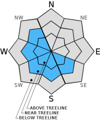
Pockets of MODERATE avalanche danger exist on near and above treeline SE-S-SW-W-NW aspects loaded by the NE winds on slopes 35 degrees and steeper due to the presence of newly formed wind slabs. Areas south and east of Lake Tahoe where the most new snow fell represent the most likely places to find MODERATE avalanche danger. Human-triggered wind slab avalanches are possible today.

2. Moderate

?

Above Treeline
Heightened avalanche conditions on specific terrain features. Evaluate snow and terrain carefully; identify features of concern.

2. Moderate

?

Near Treeline
Heightened avalanche conditions on specific terrain features. Evaluate snow and terrain carefully; identify features of concern.

1. Low

?

Below Treeline
Generally safe avalanche conditions. Watch for unstable snow on isolated terrain features.
    Heightened avalanche conditions on specific terrain features. Evaluate snow and terrain carefully; identify features of concern.
Avalanche Problem 1: Wind Slab
  • Type ?
  • Aspect/Elevation ?
  • Likelihood ?
    Certain
    Very Likely
    Likely
    Possible
    Unlikely
  • Size ?
    Historic
    Very Large
    Large
    Small

Strong northeast winds and new snow have deposited new wind slabs on some of the SE-S-SW-W-NW aspects. Human triggered avalanches involving these wind slabs will be possible today. The largest of these wind slabs will exist in areas south and east of Lake Tahoe where the most snow fell, and in these areas wind slabs could reach 1 to 2 ft. in depth on the most heavily wind loaded slopes. In most other areas where less snow fell these slabs should remain relatively small, and should not extend very far down slope. The most fragile wind slabs will exist on wind loaded slopes in near and above treeline terrain.

recent observations

Yesterday observations from Castle Peak and Incline Lake Peak showed variable surface conditions ranging from scoured icy surfaces on exposed near and above treeline slopes to unconsolidated snow on top of crusts on sheltered northerly aspects. In both areas snowpit data continues to hint at a weak layer forming just below the rain crust. In the Incline Lake Peak area the rain crust seems to be eroding and the burgeoning weak layer seemed more well developed. Below the rain crust data indicates a strong snowpack.

Weather and CURRENT CONDITIONS
weather summary

The cold front arrived last night bringing cold air, strong north to northeast winds, and some cold, light snow to the forecast area. Remote senors indicate about 2 to 4 inches of new snow has accumulated with areas south and east of Lake Tahoe receiving the most snow due to lake effect snow. One sensor in the Heavenly area reports 7 inches of new snow. Up to 2 more inches of new snow may fall today before the storm moves out of the area. The strong northeast winds and cold air temperatures should remain over the forecast region for the next 24 hours with the strongest winds and coldest temperatures occurring tonight. The forecast calls for daytime highs in the single digits and teens in the mountains today with overnight lows near or below zero tonight. Upper elevation winds during this time should average between 55 and 75 mph with some gusts around 110 mph tonight. By tomorrow temperatures should start gradually warming up with daytime highs in the upper teens above 7000 ft. The northeast winds will remain strong tomorrow but as the day progresses they should begin to decrease.

CONDITIONS ALONG THE SIERRA CREST BETWEEN 8200 FT. AND 9200 FT. IN THE LAST 24 HOURS
6am temperature: 8 to 16 deg. F.
Max. temperature: 24 to 35 deg. F.
Average ridgetop wind direction: West to Northeast
Average ridgetop wind speed: 25 to 35 mph
Maximum ridgetop wind gust: 68 mph
New snowfall: 2 to 4 inches
Total snow depth: 26 to 40 inches
Two-Day Mountain Weather Forecast Produced in partnership with the Reno NWS
For 7000 ft. to 8000 ft.
Tuesday Tuesday Night Wednesday
Weather: Cloudy with snow showers in the morning becoming mostly cloudy with isolated snow showers in the afternoon Partly cloudy Partly cloudy becoming sunny
Temperatures: 9 to 16 deg. F. -3 to 4 deg. F. 15 to 20 deg. F.
Mid Slope Winds: Northeast Northeast to east East
Wind Speed: 20 to 35 mph with gusts to 45 mph increasing to 30 to 40 mph with gusts to 55 mph in the afternoon 35 to 45 mph with gusts to 65 mph 35 to 45 mph with gusts to 65 mph decreasing to 30 to 35 mph with gusts to 50 mph in the afternoon
Expected snowfall: up to 2 0 0
For 8000 ft. to 9000 ft.
Tuesday Tuesday Night Wednesday
Weather: Cloudy with snow showers in the morning becoming mostly cloudy with isolated snow showers in the afternoon Partly cloudy Partly cloudy becoming sunny
Temperatures: 4 to 11 deg. F. -5 to 2 deg. F. 15 to 20 deg. F.
Ridge Top Winds: East shifting to northeast in the afternoon Northeast East shifting to northeast in the afternoon
Wind Speed: 40 to 45 mph with gusts to 65 mph increasing to 55 to 60 mph with gusts to 85 mph in the afternoon 65 to 75 mph with gusts to 110 mph 55 to 60 mph with gusts to 90 mph decreasing to 40 to 45 mph with gusts to 70 mph in the afternoon
Expected snowfall: up to 2 0 0
Disclaimer

This avalanche advisory is provided through a partnership between the Tahoe National Forest and the Sierra Avalanche Center. This advisory covers the Central Sierra Nevada Mountains between Yuba Pass on the north and Ebbetts Pass on the south. Click here for a map of the forecast area. This advisory applies only to backcountry areas outside established ski area boundaries. This advisory describes general avalanche conditions and local variations always occur. This advisory expires 24 hours after the posted time unless otherwise noted. The information in this advisory is provided by the USDA Forest Service who is solely responsible for its content.