THIS AVALANCHE FORECAST EXPIRED ON December 10, 2014 @ 6:30 am
Avalanche Forecast published on December 9, 2014 @ 6:30 am
Issued by Brandon Schwartz - Tahoe National Forest

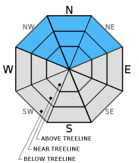
Avalanche danger is LOW for all elevations and aspects. Normal caution is advised.


1. Low

?

Above Treeline
Generally safe avalanche conditions. Watch for unstable snow on isolated terrain features.

1. Low

?

Near Treeline
Generally safe avalanche conditions. Watch for unstable snow on isolated terrain features.

1. Low

?

Below Treeline
Generally safe avalanche conditions. Watch for unstable snow on isolated terrain features.
    Generally safe avalanche conditions. Watch for unstable snow on isolated terrain features.
Avalanche Problem 1: Normal Caution
  • Type ?
  • Aspect/Elevation ?
  • Likelihood ?
    Certain
    Very Likely
    Likely
    Possible
    Unlikely
  • Size ?
    Historic
    Very Large
    Large
    Small

Isolated persistent slab avalanches are a very low likelihood problem at this time. A difficult to trigger weak layer of basal facets lingers above 9,000'-9,500' on NW-N-NE aspects. The most likely points for human triggering exist at relative shallow areas of the snowpack commonly found near exposed rocks, isolated trees, and along cliff bands. Exercise normal caution and manage terrain to avoid potential trigger points.

The bigger picture issue is how these facets will react to the expected new snow loading Thurs/Fri. If the current forecast of several feet of new snow above 8,000' verifies, large and potentially destructive deep persistent slab avalanches could very well become a concern. It is still a bit early to commit to this line of thinking, but file it away and start brainstorming appropriate terrain and snowpack management techniques for deep persistent slabs. As seen in yesterday's observations, slopes that received heavy traffic after the last storm will not be immune. After brainstorming for a bit, check here for accuracy of ideas and further guidance.

recent observations

Observations made yesterday on Incline Lake Peak (Mount Rose area) showed that the basal facets that exist on NW-N-NE aspects above 9,000'-9,500' remain problematic. Despite some evidence of rounding, these facets remain loose grain and weak. Snowpit tests performed on a N aspect, ski track covered slope at 9,500' showed that the weak layer and overlying slab retain the necessary characteristics for sudden collapse and propagation of fracture over distance. This is despite all of the traffic that the snowpack in this area has received. (video)

Weather and CURRENT CONDITIONS
weather summary

Mild weather is in store for today with mostly cloudy skies, light winds, and maximum daytime air temperatures in the 40s for areas above 7,000'. Remote sensors are reporting air temperatures in the mid to upper 30s this morning for areas between 8,200' and 8,800'. Ridgetop winds are forecast to increase to gale force tomorrow afternoon with gusts to 80 mph ahead of the approaching storm system. A short video briefing from NWS Reno on the upcoming storm is available here.
 

CONDITIONS ALONG THE SIERRA CREST BETWEEN 8200 FT. AND 9200 FT. IN THE LAST 24 HOURS
6am temperature: 32 to 39 deg. F.
Max. temperature: 37 to 45 deg. F.
Average ridgetop wind direction: Southwest
Average ridgetop wind speed: 19 mph
Maximum ridgetop wind gust: 31 mph
New snowfall: 0 inches
Total snow depth: 13 to 28 inches
Two-Day Mountain Weather Forecast Produced in partnership with the Reno NWS
For 7000 ft. to 8000 ft.
Tuesday Tuesday Night Wednesday
Weather: Mostly cloudy skies. Mostly cloudy skies. Mostly cloudy skies.
Temperatures: 39 to 46 deg. F. 27 to 34 deg. F. 42 to 49 deg. F.
Mid Slope Winds: SW SW SW
Wind Speed: Light winds. 10 to 15 mph with gusts to 25 mph after midnight. 10 to 15 mph with gusts to 25 mph, increasing to 25 to 30 mph with gusts to 45 mph in the afternoon.
Expected snowfall: 0 0 0
For 8000 ft. to 9000 ft.
Tuesday Tuesday Night Wednesday
Weather: Mostly cloudy skies. Mostly cloudy skies. Mostly cloudy skies.
Temperatures: 41 to 47 deg. F. 28 to 35 deg. F. 39 to 46 deg. F.
Ridge Top Winds: SW SW SW
Wind Speed: 10 to 15 mph 15 to 20 mph with gusts to 30 mph. 20 to 25 mph with gusts to 40 mph, increasing to 45 to 50 mph with gusts to 80 mph in the afternoon.
Expected snowfall: 0 0 0
Disclaimer

This avalanche advisory is provided through a partnership between the Tahoe National Forest and the Sierra Avalanche Center. This advisory covers the Central Sierra Nevada Mountains between Yuba Pass on the north and Ebbetts Pass on the south. Click here for a map of the forecast area. This advisory applies only to backcountry areas outside established ski area boundaries. This advisory describes general avalanche conditions and local variations always occur. This advisory expires 24 hours after the posted time unless otherwise noted. The information in this advisory is provided by the USDA Forest Service who is solely responsible for its content.