


For 7000 ft. to 8000 ft.
| Wednesday | Wednesday Night | Thursday | |
|---|---|---|---|
| Weather: | Partly cloudy. | Mostly cloudy, slight chance of snow after midnight. | Cloudy, then becoming mostly cloudy. Slight chance of snow. |
| Temperatures: | 30 to 35 deg. F. | 19 to 26 deg. F. | 35 to 40 deg. F. |
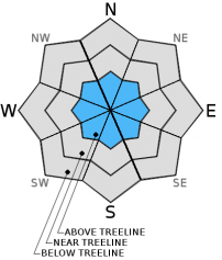
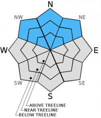
| Mid Slope Winds: | Variable | W | SW |
| Wind Speed: | 5 to 15mph | 5 to 15mph | 10 to 15mph with gusts to 25mph. |
| Expected snowfall: | 0 | 0 | 0 |
For 8000 ft. to 9000 ft.
| Wednesday | Wednesday Night | Thursday | |
|---|---|---|---|
| Weather: | Partly cloudy. | Mostly cloudy, slight chance of snow after midnight. | Mostly cloudy, slight chance of snow. |
| Temperatures: | 24 to 31 deg. F. | 19 to 24 deg. F. | 30 to 35 deg. F. |
| Ridge Top Winds: | NW | W | W |
| Wind Speed: | 15 to 25mph with gusts to 40. | 20 to 30mph with gusts to 45mph. | 20 to 30mph with gusts to 45mph. |
| Expected snowfall: | 0 | 0 | 0 |


