THIS AVALANCHE FORECAST EXPIRED ON December 18, 2015 @ 7:00 am
Avalanche Forecast published on December 17, 2015 @ 7:00 am
Issued by Andy Anderson - Tahoe National Forest - Sierra Avalanche Center

The avalanche danger has decreased to LOW for all elevations and aspects. LOW avalanche danger means that while avalanche activity may be unlikely, it is not impossible. Unstable snow in the form of small isolated wind slabs or persistent slabs could still exist on isolated terrain features especially in complex or extreme terrain.

1. Low

?

Above Treeline
Generally safe avalanche conditions. Watch for unstable snow on isolated terrain features.

1. Low

?

Near Treeline
Generally safe avalanche conditions. Watch for unstable snow on isolated terrain features.

1. Low

?

Below Treeline
Generally safe avalanche conditions. Watch for unstable snow on isolated terrain features.
    Generally safe avalanche conditions. Watch for unstable snow on isolated terrain features.
Avalanche Problem 1: Persistent Slab
  • Type ?
  • Aspect/Elevation ?
  • Likelihood ?
    Certain
    Very Likely
    Likely
    Possible
    Unlikely
  • Size ?
    Historic
    Very Large
    Large
    Small

Triggering a persistent slab avalanche has become unlikely. Data from around the forecast area indicates that the persistent weak layers present in the snowpack have adjusted to the load above them and that if they do break the resulting fractures would not travel very far along those buries layers. However, some variability and uncertainty surrounds persistent weak layers and persistent slab avalanches. If the right trigger found the right spot on a slope where a persistent weak layer exists around one of the buried rain crusts, a human triggered persistent slab avalanche is not impossible today. Large triggers like multiple people on a slope or large cornice failures would have better chances of triggering an unlikely but not impossible persistent slab.

Avalanche Problem 2: Wind Slab
  • Type ?
  • Aspect/Elevation ?
  • Likelihood ?
    Certain
    Very Likely
    Likely
    Possible
    Unlikely
  • Size ?
    Historic
    Very Large
    Large
    Small

The wind slabs that linger on many aspects above treeline have grown difficult to trigger since they have bonded to the snowack below them in most areas. Even though avalanches involving these wind slabs have become unlikely, some unstable wind slabs may still linger on isolated, steep, wind-loaded terrain features like couliors, unsupported wind-loaded slopes above cliff bands, or other complex/extreme terrain.

recent observations

Yesterday, observations from around the forecast area indicated a trend of settlement and consolidation in the snowpack. Snowpit tests and data from Rubicon (on the West Shore), Trestle Peak (near Donner Summit), Tamarack Peak (Mt. Rose backcountry), and Indian Valley (between Ebbetts Pass and Carson Pass) did not reveal any obvious signs of instability. Some of the data did indicate that the snow around the 12/13 rain crust has the potential to pose future problems when additional snow load arrives. In all of these areas the NE winds had scoured much of the recent snow away from the upper-elevation, exposed, N-NE-E aspects leaving behind firm wind pack surfaces and exposed crusts. On the more sheltered N-NE-E aspects the surface snow remained cold and soft. Observers also reported that sunshine and warm temperatures allowed some wet surface snow to form on sun-exposed southerly aspects by yesterday afternoon. Ski cuts in the Tamarack Peak area and snowmobile cuts in the Indian Valley area on some wind loaded test slopes caused some very small dinner-plate size cracking in small, shallow, isolated, and inconsequential wind slabs 

Weather and CURRENT CONDITIONS
weather summary

Overnight lows measured in the upper 20's and low 30's last night due to warmer air and some cloud cover moving into the area. Temperatures should remain warmer than the last few days with daytime highs climbing into the mid to upper 30's above 7000 ft. today and possibly into the low 40's tomorrow. Skies shoud remain partly to mostly cloudy through tomorrow. The wind shifted back to the southwest overnight and should start to increase during the next 36 hours as another storm that is predicted to arrive on Saturday approaches the area. Check in with the Reno NWS for more details. 

CONDITIONS ALONG THE SIERRA CREST BETWEEN 8200 FT. AND 9200 FT. IN THE LAST 24 HOURS
6am temperature: 26 to 30 deg. F.
Max. temperature: 30 to 36 deg. F.
Average ridgetop wind direction: Northwest to southwest
Average ridgetop wind speed: 10 to 15 mph
Maximum ridgetop wind gust: 31 mph
New snowfall: 0 inches
Total snow depth: 30 to 40 inches
Two-Day Mountain Weather Forecast Produced in partnership with the Reno NWS
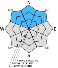
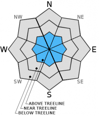
For 7000 ft. to 8000 ft.
Thursday Thursday Night Friday
Weather: Mostly cloudy with a slight chance of snow Mostly cloudy becoming partly cloudy overnight Partly cloudy with a slight chance of snow in the afternoon
Temperatures: 34 to 39 deg. F. 23 to 31 deg. F. 38 to 43 deg. F.
Mid Slope Winds: Southwest Southwest Southwest
Wind Speed: 10 to 20 mph with gusts to 30 mph 15 to 25 mph with gusts to 35 mph 15 to 25 mph with gusts to up to 35 mph
Expected snowfall: trace to 0 0 0
For 8000 ft. to 9000 ft.
Thursday Thursday Night Friday
Weather: Mostly cloudy with a slight chance of snow Mostly cloudy becoming partly cloudy overnight Partly cloudy with a slight chance of snow in the afternoon
Temperatures: 29 to 36 deg. F. 21 to 28 deg. F. 33 to 40 deg. F.
Ridge Top Winds: Southwest Southwest Southwest
Wind Speed: 20 to 30 mph with gusts to 40 mph 20 to 30 mph with gusts to 40 mph 35 to 45 mph with gusts to 60 mph increasing to 45 to 50 mph with gusts to 85 mph in the afternoon
Expected snowfall: trace to 0 0 0
Disclaimer

This avalanche advisory is provided through a partnership between the Tahoe National Forest and the Sierra Avalanche Center. This advisory covers the Central Sierra Nevada Mountains between Yuba Pass on the north and Ebbetts Pass on the south. Click here for a map of the forecast area. This advisory applies only to backcountry areas outside established ski area boundaries. This advisory describes general avalanche conditions and local variations always occur. This advisory expires 24 hours after the posted time unless otherwise noted. The information in this advisory is provided by the USDA Forest Service who is solely responsible for its content.