THIS AVALANCHE FORECAST EXPIRED ON December 19, 2015 @ 6:57 am
Avalanche Forecast published on December 18, 2015 @ 6:57 am
Issued by Andy Anderson - Tahoe National Forest - Sierra Avalanche Center

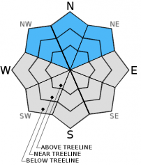
The avalanche danger will remain LOW for all elevations and aspects today. LOW avalanche danger means that while avalanche activity may be unlikely, it is not impossible. Unstable snow in the form of small isolated persistent slabs could still exist on isolated terrain features especially in complex or extreme terrain or on pockets of sheltered NW-N-NE aspects. The avalanche danger will increase tonight and tomorrow as another winter storm impacts the region.

1. Low

?

Above Treeline
Generally safe avalanche conditions. Watch for unstable snow on isolated terrain features.

1. Low

?

Near Treeline
Generally safe avalanche conditions. Watch for unstable snow on isolated terrain features.

1. Low

?

Below Treeline
Generally safe avalanche conditions. Watch for unstable snow on isolated terrain features.
    Generally safe avalanche conditions. Watch for unstable snow on isolated terrain features.
Avalanche Problem 1: Persistent Slab
  • Type ?
  • Aspect/Elevation ?
  • Likelihood ?
    Certain
    Very Likely
    Likely
    Possible
    Unlikely
  • Size ?
    Historic
    Very Large
    Large
    Small

Human triggered avalanches are unlikley today. Recent observations have shown a strengthening snowpack across the forecast area. The warmer temperatures and deeper snowpack have also allowed many of the old persistent weak layers to heal and most of them no longer represent a problem. However, some variability and uncertainty still surrounds the persistent weak layer just below the 12/13 rain crust about 1 ft. below the surface of the snowpack. Most tests on this layer have indicated that it has gone dormant; however, a few tests still show unstable results on this layer. Any instabilities involving this layer will remain isolated, small,  and hard to find today, but they are not impossible. If the right trigger found the right spot on one of these isolated slopes where this layer exists, a human triggered persistent slab avalanche would not be impossible today. Large triggers like multiple people on a slope or large cornice failures would have better chances of triggering an unlikely but not impossible persistent slab.

Other than this uncertain, unlikely, and isolated potential problem, some other small areas of unstable snow may still linger on isolated terrain features in complex or extreme terrain. Continue to use normal caution when traveling in the backcountry.  

recent observations

Yesterday cloud cover and warming temperatures allowed wet snow to form on all aspects at lower elevations on Jakes's Peak and on Talking Mountain. At higher elevations on these peaks and on Incline Lake Peak, heavy wet snow existed on all but the north aspects by yesterady afternoon. Observations from these areas mostly showed a trend of settlement and consolidation in the snowpack, but some variablity existed in snowpit test results on Jake's Peak and Talking Mountian. Most tests indicated a strengthening trend, but some of the tests still indicated that fractures might propagate along a weak layer just below the 12/13 rain crust in some isolated areas. Some surface hoar had formed on the lower slopes of Talking Mountain closer to Echo Lake. Observers did not report surface hoar on Jake's or Incline Lake Peak. 

Weather and CURRENT CONDITIONS
weather summary

Winds have shifted to the southwest and started to increase ahead of a modest winter storm. These winds should continue to increase through tonight. Cloud cover should begin to spread over the forecast area today and snow should start falling tonight. The forecast calls for snow levels to start around 5500 to 6000 ft. 2 to 5 inches of new snow could fall across the forecast area tonight with most of this snow accumulating after midnight. The storm should continue into tomorrow with another 2 to 5 inches of snow. Colder air will accompany this storm and daytime highs tomorrow should only reach into the mid to upper 20's above 7000 ft. By tomorrow afternoon and evening the southwest winds should start to decrease and snowfall should begin to taper off. Check in with the Reno NWS for more details.

CONDITIONS ALONG THE SIERRA CREST BETWEEN 8200 FT. AND 9200 FT. IN THE LAST 24 HOURS
6am temperature: 22 to 32 deg. F.
Max. temperature: 32 to 37 deg. F.
Average ridgetop wind direction: Southwest
Average ridgetop wind speed: Before midnight: 20-30 mph | After midnight: 40-50 mph
Maximum ridgetop wind gust: 68 mph
New snowfall: trace to 0 inches
Total snow depth: 29 to 41 inches
Two-Day Mountain Weather Forecast Produced in partnership with the Reno NWS
For 7000 ft. to 8000 ft.
Friday Friday Night Saturday
Weather: Partly cloudy with slight chance of snow in the afternoon Mostly cloudy with snow becoming likely after midnight Snow
Temperatures: 36 to 43 deg. F. 21 to 29 deg. F. 26 to 33 deg. F.
Mid Slope Winds: Southwest Southwest Southwest
Wind Speed: 15 to 20 mph with gusts to 35 mph increasing to 25 to 35 mph with gusts to 50 mph in the afternoon 25 to 35 mph with gusts to 50 mph 15 to 20 mph with gusts to 35 mph
Expected snowfall: 0 3 to 5 2 to 5
For 8000 ft. to 9000 ft.
Friday Friday Night Saturday
Weather: Partly cloudy with slight chance of snow in the afternoon Mostly cloudy with snow becoming likely after midnight Snow
Temperatures: 33 to 40 deg. F. 18 to 25 deg. F. 22 to 29 deg. F.
Ridge Top Winds: Southwest Southwest Southwest
Wind Speed: 50 to 55 mph with gusts to 80 mph increasing to 60 to 65 mph with gusts to 100 mph in the afternoon 60 to 70 mph with gusts to 100 mph 50 to 55 mph with gusts to 85 mph decreasing to 35 to 40 mph with gusts to 60 mph in the afternoon
Expected snowfall: 0 3 to 5 2 to 5
Disclaimer

This avalanche advisory is provided through a partnership between the Tahoe National Forest and the Sierra Avalanche Center. This advisory covers the Central Sierra Nevada Mountains between Yuba Pass on the north and Ebbetts Pass on the south. Click here for a map of the forecast area. This advisory applies only to backcountry areas outside established ski area boundaries. This advisory describes general avalanche conditions and local variations always occur. This advisory expires 24 hours after the posted time unless otherwise noted. The information in this advisory is provided by the USDA Forest Service who is solely responsible for its content.