THIS AVALANCHE FORECAST EXPIRED ON December 3, 2015 @ 7:01 am
Avalanche Forecast published on December 2, 2015 @ 7:01 am
Issued by Andy Anderson - Tahoe National Forest - Sierra Avalanche Center

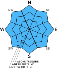
The avalanche danger remains LOW on all aspects and elevations. Avalanches remain unlikely but not impossible. Some unstable snow could still exist on isolated terrain features due to the presence of lingering persistent weak layers. The shallow snowpack means that numerous rocks, stumps, logs and other hazards remain exposed or barely covered. 

1. Low

?

Above Treeline
Generally safe avalanche conditions. Watch for unstable snow on isolated terrain features.

1. Low

?

Near Treeline
Generally safe avalanche conditions. Watch for unstable snow on isolated terrain features.

1. Low

?

Below Treeline
Generally safe avalanche conditions. Watch for unstable snow on isolated terrain features.
    Generally safe avalanche conditions. Watch for unstable snow on isolated terrain features.
Avalanche Problem 1: Normal Caution
  • Type ?
  • Aspect/Elevation ?
  • Likelihood ?
    Certain
    Very Likely
    Likely
    Possible
    Unlikely
  • Size ?
    Historic
    Very Large
    Large
    Small

While avalanche activity remains unlikely across the forecast area, potential weak layers still exist in the form of weak faceted snow in the bottom half of the snowpack on some NW-N-NE aspects. Snowpit tests continue to show unstable results associated with these layers in some isolated places. These layers could become more of an issue as more snow accumulates across the forecast area. Knowing where these layers exist now and how weak they currently are can help make more informed decisions when the snowpack becomes deeper. The numerous anchors like rocks, stumps, logs and other shallowly buried or still exposed obstacles that protrude through these layers have kept them from becoming continuous over large areas and have kept the pockets of instability small and isolated. These anchors also make hitting hard immovable objects while traveling through the snow likely in most areas.  

recent observations

Yesterday on Elephant's Hump in the Carson Pass area, snowpack depths ranged from 18 to 36 inches on most northerly aspects with less snow on the south and west aspects. Rocks, stumps, logs, and other obstacles still remain very close to the surface and easy to hit. Below the surface snowpit data showed a more consolidated and stronger snowpack than has been seen in some other areas around the region. A weak layer still existed at the bottom of the snowpack, but tests targeting this layer indicated that fracture propagation through this layer has become unlikely and that the snowpack continues to gain strength. Other data from Donner Summit and the Mt. Rose backcountry still shows signs of instability associated with similar layers in some areas. 

Weather and CURRENT CONDITIONS
weather summary

The lower elevations remain colder than the upper elevations due to cold air sinking into the valleys and remaining trapped there. High pressure over the region will keep this inversion in place today; however, it may start to lift and mix out as the winds begin to increase this afternoon. Some cloud cover and increased south and southwest winds should start to move into the area today as a low pressure system moves closer to the region. By tomorrow afternoon the winds could reach into the 50 to 75 mph range along the ridgelines with gusts above 100 mph. Snowfall associated with this system could start as early as tomorrow afternoon, but most of the snowfall should fall between 4 pm and 10 pm tomorrow. Currently the forecast calls for 6-12 inches of snow above 7000 ft. by Friday morning. Check in with the Reno NWS for more details.

CONDITIONS ALONG THE SIERRA CREST BETWEEN 8200 FT. AND 9200 FT. IN THE LAST 24 HOURS
6am temperature: 29 to 35 deg. F.
Max. temperature: 37 to 44 deg. F.
Average ridgetop wind direction: West
Average ridgetop wind speed: 20 to 25 mph
Maximum ridgetop wind gust: 56 mph
New snowfall: 0 inches
Total snow depth: 15 to 21 inches
Two-Day Mountain Weather Forecast Produced in partnership with the Reno NWS
For 7000 ft. to 8000 ft.
Wednesday Wednesday Night Thursday
Weather: Mostly cloudy Mostly cloudy Mostly cloudy with a 50% chance of snow in the afternoon between 2 and 6 pm.
Temperatures: 38 to 45 deg. F. 28 to 38 deg. F. 32 to 39 deg. F.
Mid Slope Winds: Southwest South South
Wind Speed: 10 to 20 mph 10 to 20 mph increasing to 20 to 30 mph with gusts to 40 mph after midnight 25 to 40 mph with gusts to 60 mph
Expected snowfall: 0 0 up to 2
For 8000 ft. to 9000 ft.
Wednesday Wednesday Night Thursday
Weather: Mostly cloudy Mostly cloudy Mostly cloudy with a 50% chance of snow in the afternoon between 2 and 6 pm.
Temperatures: 37 to 44 deg. F. 30 to 36 deg. F. 28 to 34 deg. F.
Ridge Top Winds: Southwest South South shifting to southwest
Wind Speed: 25 to 40 mph with gusts to 50 mph decreasing to 15 to 25 mph in the afternoon 20 to 30 mph with gusts to 40 mph increasing to 30 to 40 mph with gusts to 60 mph after midnight 50 to 65 mph with gusts to 90 mph increasing to 60 to 75 mph with gusts between 100 and 115 mph in the afternoon
Expected snowfall: 0 0 up to 2
Disclaimer

This avalanche advisory is provided through a partnership between the Tahoe National Forest and the Sierra Avalanche Center. This advisory covers the Central Sierra Nevada Mountains between Yuba Pass on the north and Ebbetts Pass on the south. Click here for a map of the forecast area. This advisory applies only to backcountry areas outside established ski area boundaries. This advisory describes general avalanche conditions and local variations always occur. This advisory expires 24 hours after the posted time unless otherwise noted. The information in this advisory is provided by the USDA Forest Service who is solely responsible for its content.