THIS AVALANCHE FORECAST EXPIRED ON December 26, 2015 @ 7:01 am
Avalanche Forecast published on December 25, 2015 @ 7:01 am
Issued by Andy Anderson - Tahoe National Forest - Sierra Avalanche Center

Human triggered avalanches will remain possible today on slopes 35 degrees and steeper at all elevations on NW-N-NE-E-SE aspects and in above treeline terrain on all aspects. Wind slabs, loose dry avalanches, and some isolated storm slabs represent the main avalanche problems today with deep slabs on NW-N-NE aspects representing a very unlikely but not impossible problem. Evaluate snow and terrain carefully before committing to a slope.

2. Moderate

?

Above Treeline
Heightened avalanche conditions on specific terrain features. Evaluate snow and terrain carefully; identify features of concern.

2. Moderate

?

Near Treeline
Heightened avalanche conditions on specific terrain features. Evaluate snow and terrain carefully; identify features of concern.

2. Moderate

?

Below Treeline
Heightened avalanche conditions on specific terrain features. Evaluate snow and terrain carefully; identify features of concern.
    Heightened avalanche conditions on specific terrain features. Evaluate snow and terrain carefully; identify features of concern.
Avalanche Problem 1: Wind Slab
  • Type ?
  • Aspect/Elevation ?
  • Likelihood ?
    Certain
    Very Likely
    Likely
    Possible
    Unlikely
  • Size ?
    Historic
    Very Large
    Large
    Small

The wind slabs that formed yesterday will remain sensitive to human triggering today. These wind slabs exist above icy crusts and firm snow surfaces, and it will take some time for them to bond with these old snow surfaces. Continued wind loading from west and northwest winds mean that these slabs will slowly continue to grow today and some small new wind slabs may even form on S aspects near ridgelines. In addition to these small new wind slabs, larger fragile wind slabs will still exist on wind loaded N-NE-E and cross loaded NW and SE aspects in exposed near and above treeline terrain. Some smaller wind slabs could exist on open slopes exposed to the wind at lower elevations as well. Avalanches involving these wind slabs could involve enough to bury a person.

Avalanche Problem 2: Loose Dry
  • Type ?
  • Aspect/Elevation ?
  • Likelihood ?
    Certain
    Very Likely
    Likely
    Possible
    Unlikely
  • Size ?
    Historic
    Very Large
    Large
    Small

In most areas the new snow will still remain too unconsolidated to behave like a slab and loose dry avalanches/sluffs will still represent the main below treeline issue. These sluffs would involve the new snow sliding on the frozen crusts below. While they may not involve enough snow to bury a person, they could push people into areas with other consequences like hitting trees or going over cliffs. These sluffs will mostly occur on sheltered terrain on slopes steeper than 38 degrees. 

Avalanche Problem 3: Storm Slab
  • Type ?
  • Aspect/Elevation ?
  • Likelihood ?
    Certain
    Very Likely
    Likely
    Possible
    Unlikely
  • Size ?
    Historic
    Very Large
    Large
    Small

In some isolated areas, yesterday's snow may form bonds within itself faster than it will form bonds with the icy crusts below it. As this new snow becomes more cohesive, it will also become more slab-like. In these isolated areas, some human trigger-able storm slabs may exist on open below treeline slopes with little or no wind affect today. Like the loose dry sluffs mentioned above these avalanches will only involve the new snow and not move enough snow to bury a person or may involve barely enough snow to bury a person in some cases. They will be more likely to have serious consequences around terrain traps that can magnify the consequences of these smaller avalanches.

Forecast discussion

In regards to the deep slab issues, most recent snowpit data has indicated that the persistent weak layer issues along the Sierra Crest have subsided. So far we do not have enough data to say that it is completely gone. In the Mt. Rose backcountry tests still show a layer of old facets lurking near the base of the snowpack underneath the 12/10 rain crust. Observations have indicated that NW-N-NE aspects in more sheltered terrain represent the best places to find this layer and that even in this kind of terrain it doesn't exist on every slope. Even in the places that it does exist, it may have gone dormant in some spots. Actually getting enough force through that strong upper snowpack to break this layer or the buried surface hoar layer along the Sierra Crest (if it still exists) would be very difficult and require a very large trigger like a giant cornice collapse, another large avalanche, or maybe several people on a slope at once. Still, in the unlikely event that one of these layers were to break, huge avalanches would result. Even though these kind of avalanches are unlikely and are becoming more and more unlikely with each passing day, the consequences associated with them are dire, and paying attention to where these layers may possibly exist and whether or not they still have potential to let fractures travel through them is still a wise choice. 

recent observations

Yesterday on Hidden Peak, hand pits, ski cuts on test slopes, snowpit data, and general observations all indicated that the new snow had not formed good bonds with the frozen crusts that represent the old snow surface. Observations also showed that the new snow remained soft, unconsolidated,  and did not have many slab-like characteristics in areas sheltered from the wind. Any place that the wind could affect the snow, the new snow behaved more like a slab. Ski cuts on some wind affected test slopes did cause small wind slab failures in near and above treeline terrain and small soft slab failures in open below treeline terrain. Ski cuts on steep test slopes also triggered small sluffs in some areas. Parties also reported some skier triggered sluffs and cracking on Jake's and Rubicon. Snowpit data on Hidden Peak showed that the 12/13 rain crust with surface hoar underneath it has become very difficult to identify, and tests did not reveal any lingering instability associated with this layer. Observers also noted active wind loading along the summit ridge line of Hidden Peak. 

Weather and CURRENT CONDITIONS
weather summary

Since yesterday 11 to 18 inches of new cold snow has accumulated across the forecast area. Scattered snow showers should continue today due to another weak disturbance on the heels of yesterday's storm. This should pass through the area today leaving behind a trace of new snow and continued cold temperatures. The forecast calls for daytime highs in the teens. A high pressure ridge should start to build over the region tonight bringing clearing skies, even colder overnight lows in the single digits and maybe below zero, and strong north and east winds. These winds will remain strong and continue through tomorrow. 

CONDITIONS ALONG THE SIERRA CREST BETWEEN 8200 FT. AND 9200 FT. IN THE LAST 24 HOURS
6am temperature: 6 to 12 deg. F.
Max. temperature: 17 to 22 deg. F.
Average ridgetop wind direction: Southwest to west
Average ridgetop wind speed: Yesterday: 40 to 50 mph | Since 10 pm: 20 to 30 mph
Maximum ridgetop wind gust: 109 mph
New snowfall: 11 to 18 inches
Total snow depth: 53 to 66 inches
Two-Day Mountain Weather Forecast Produced in partnership with the Reno NWS
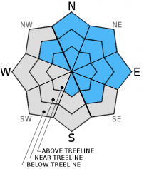
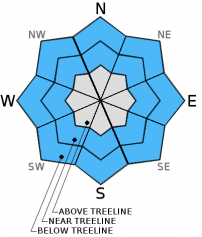
For 7000 ft. to 8000 ft.
Friday Friday Night Saturday
Weather: Mostly cloudy with scattered snow showers Partly cloudy becoming clear overnight Sunny
Temperatures: 11 to 18 deg. F. 1 to 7 deg. F. 18 to 25 deg. F.
Mid Slope Winds: West North shifting to northeast after midnight East
Wind Speed: 15 to 20 mph with gusts to 35 mph 15 to 20 mph with gusts to 35 mph increasing to 25 to 30 mph with gusts to 45 mph 25 to 35 mph with gusts to 55 mph
Expected snowfall: up to 1 0 0
For 8000 ft. to 9000 ft.
Friday Friday Night Saturday
Weather: Mostly cloudy with scattered snow showers Partly cloudy becoming clear overnight Sunny
Temperatures: 9 to 15 deg. F. -2 to 5 deg. F. 18 to 25 deg. F.
Ridge Top Winds: Northwest North shifting to northeast after midnight East
Wind Speed: 20 to 30 mph with gusts to 45 mph 25 to 30 mph with gusts to 45 mph increasing to 35 to 45 mph with gusts to 60 mph 40 to 50 mph with gusts to 75 mph
Expected snowfall: up to 1 0 0
Disclaimer

This avalanche advisory is provided through a partnership between the Tahoe National Forest and the Sierra Avalanche Center. This advisory covers the Central Sierra Nevada Mountains between Yuba Pass on the north and Ebbetts Pass on the south. Click here for a map of the forecast area. This advisory applies only to backcountry areas outside established ski area boundaries. This advisory describes general avalanche conditions and local variations always occur. This advisory expires 24 hours after the posted time unless otherwise noted. The information in this advisory is provided by the USDA Forest Service who is solely responsible for its content.