


For 7000 ft. to 8000 ft.
| Wednesday | Wednesday Night | Thursday | |
|---|---|---|---|
| Weather: | Mostly cloudy. Isolated snow showers throughout the day. | Partly cloudy. | Sunny |
| Temperatures: | 22 to 29 deg. F. | 4 to 12 deg. F. | 18 to 25 deg. F. |
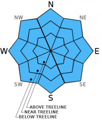
| Mid Slope Winds: | NW | E | E |
| Wind Speed: | 10 to 20mph with gusts to 25mph. | 10 to 15mph with gusts to 25mph. | 10 to 15mph with gusts to 25mph in the afternoon. |
| Expected snowfall: | 0 | 0 | 0 |
For 8000 ft. to 9000 ft.
| Wednesday | Wednesday Night | Thursday | |
|---|---|---|---|
| Weather: | Partly cloudy. Isolated show showers through the day. | Partly cloudy. | Partly cloudy then becoming sunny. |
| Temperatures: | 19 to 26 deg. F. | 3 to 10 deg. F. | 16 to 23 deg. F. |
| Ridge Top Winds: | NW | E | E |
| Wind Speed: | 25 to 30mph with gusts to 45mph, decreasing to 20 to 25mph with gusts to 35mph in the afternoon. | 15 to 25mph with gusts to 35mph decreasing to 30mph after midnight. | 15 to 20mph with gusts to 30mph. |
| Expected snowfall: | 0 | 0 | 0 |


