THIS AVALANCHE FORECAST EXPIRED ON December 9, 2015 @ 6:57 am
Avalanche Forecast published on December 8, 2015 @ 6:57 am
Issued by Steve Reynaud - Tahoe National Forest

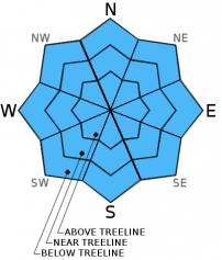
Avalanche danger remains low for all aspects and elevations.  Normal caution is advised.  Watch for unstable snow on isolated terrain features.  Early season conditions exist with low snow coverage and many obstacles present.

1. Low

?

Above Treeline
Generally safe avalanche conditions. Watch for unstable snow on isolated terrain features.

1. Low

?

Near Treeline
Generally safe avalanche conditions. Watch for unstable snow on isolated terrain features.

1. Low

?

Below Treeline
Generally safe avalanche conditions. Watch for unstable snow on isolated terrain features.
    Generally safe avalanche conditions. Watch for unstable snow on isolated terrain features.
Avalanche Problem 1: Normal Caution
  • Type ?
  • Aspect/Elevation ?
  • Likelihood ?
    Certain
    Very Likely
    Likely
    Possible
    Unlikely
  • Size ?
    Historic
    Very Large
    Large
    Small

Expect more wet surface snow with near freezing temperatures overnight and increased daytime temperatures throughout today.  This will cause an increase in surface roller ball activity but should be limited in size and mostly in the areas that received new snow on Sunday.  These roller balls should not cause a problem for backcountry users unless exposed above cliffs or other terrain traps.  Skies cleared overnight in some locations which allowed the snowpack to marginally refreeze and form thin snow surface crusts.

recent observations

Recent observations throughout the forecast area mostly point to a strengthening snowpack.  With a few exceptions, the isolated basal facets have become harder to find in their original form.  In most areas this layer is consolidating and becoming more cohesive.  There are still some isolated pockets where you can find loose, faceted snow on mostly protected north aspects at or below treeline. 

Observations from Polaris Point (Ward Canyon) showed a well consolidated snowpack with wet surface snow.  The overall snowpack depth in this area is shallow at around 16'' of snow in open areas at 7600'.  Small natural roller balls were occurring in the late morning hours off of the rocks of Polaris Point with larger skier triggered roller balls occurring while descending.  The basal facets that were previously in this area are now well rounded and consolidated snow.  Snowpack tests showed no layers of concern.

Mist to light rain was reported in many locations yesterday.

Weather and CURRENT CONDITIONS
weather summary

Weak high pressure over the forecast area with above average temperatures will continue over the next couple days.  Mid to high level cloud cover with areas above 7000' seeing near or above freezing temperatures overnight.  Highs should be in the upper 40's to low 50's above 7000' today with moderate to strong SW winds.  Forecast confidence remains high that we will see an active storm pattern develop over Northern CA later this week and into the weekend that should bring moderate to heavy precipitation to the Sierra.  A winter storm watch is in effect for late Wednesday night through late Thursday night.

CONDITIONS ALONG THE SIERRA CREST BETWEEN 8200 FT. AND 9200 FT. IN THE LAST 24 HOURS
6am temperature: 36 to 38 deg. F.
Max. temperature: 36 to 38 deg. F.
Average ridgetop wind direction: SW
Average ridgetop wind speed: 15 to 25 mph
Maximum ridgetop wind gust: 46 mph
New snowfall: 0 inches
Total snow depth: 15 to 25 inches
Two-Day Mountain Weather Forecast Produced in partnership with the Reno NWS
For 7000 ft. to 8000 ft.
Tuesday Tuesday Night Wednesday
Weather: Mostly cloudy Mostly cloudy Mostly cloudy with a slight chance of rain in the afternoon
Temperatures: 47 to 54 deg. F. 31 to 37 deg. F. 44 to 51 deg. F.
Mid Slope Winds: SW SW SW
Wind Speed: 15 to 20mph with gusts to 30mph 20 to 25mph with gusts to 40mph. Increasing 30 to 35mph with gusts to 55mph after midnight. 35 to 45mph with gusts to 70mph.
Expected snowfall: 0 0 0
For 8000 ft. to 9000 ft.
Tuesday Tuesday Night Wednesday
Weather: Mostly cloudy then becoming partly cloudy. Mostly cloudy Mostly cloudy, slight chance of rain or snow in the afternoon
Temperatures: 44 to 51 deg. F. 28 to 35 deg. F. 40 to 47 deg. F.
Ridge Top Winds: SW SW SW
Wind Speed: 20 to 30mph with gusts to 35mph increasing to 45mph in the afternoon 30 to 35mph with gust to 55mph, increasing to 45 to 50mph with gusts to 75mph 55 to 65mph with gusts to 100mph
Expected snowfall: 0 0 0
Disclaimer

This avalanche advisory is provided through a partnership between the Tahoe National Forest and the Sierra Avalanche Center. This advisory covers the Central Sierra Nevada Mountains between Yuba Pass on the north and Ebbetts Pass on the south. Click here for a map of the forecast area. This advisory applies only to backcountry areas outside established ski area boundaries. This advisory describes general avalanche conditions and local variations always occur. This advisory expires 24 hours after the posted time unless otherwise noted. The information in this advisory is provided by the USDA Forest Service who is solely responsible for its content.