THIS AVALANCHE FORECAST EXPIRED ON February 14, 2015 @ 6:45 am
Avalanche Forecast published on February 13, 2015 @ 6:45 am
Issued by Brandon Schwartz - Tahoe National Forest

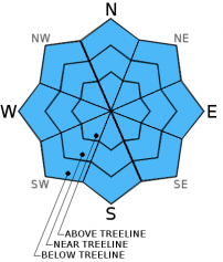
Avalanche danger remains LOW for all elevations and aspects. Isolated small loose wet avalanches remain a possibility again today on all aspects at all elevations on slopes 37 degrees and steeper. Normal caution is advised.

1. Low

?

Above Treeline
Generally safe avalanche conditions. Watch for unstable snow on isolated terrain features.

1. Low

?

Near Treeline
Generally safe avalanche conditions. Watch for unstable snow on isolated terrain features.

1. Low

?

Below Treeline
Generally safe avalanche conditions. Watch for unstable snow on isolated terrain features.
    Generally safe avalanche conditions. Watch for unstable snow on isolated terrain features.
Avalanche Problem 1: Loose Wet
  • Type ?
  • Aspect/Elevation ?
  • Likelihood ?
    Certain
    Very Likely
    Likely
    Possible
    Unlikely
  • Size ?
    Historic
    Very Large
    Large
    Small

Isolated natural but mainly human triggered loose wet avalanche activity remains possible today as the recent storm snow continues to transition to melt-freeze. With mid and upper elevation air temperatures well above freezing at sunrise, any overnight snow surface refreeze that occurred last night will quickly return to melt phase. Wet snow instability will be possible during the morning hours, increasing as the day progresses. The majority of instability is expected to continue as roller balls and pin wheels with actual loose wet avalanches a more isolated occurrence. Avalanche size is expected to remain small and could occur on all aspects at all elevations.

recent observations

Observations made yesterday on the east ridge of Relay Peak (Mount Rose area) at the site of the Feb 8 snowmobile triggered avalanche continued to show increasing snowpack stability. The low density layer of rounding faceted snow crystals at the base of the recent storm snow that was the failure layer in this avalanche was no longer reactive to snowpit tests. This matches well with recent observations over the past few days, leading to a removal of the persistent slab avalanche problem from the advisory.

Surface wet snow was widespread yesterday on all but shaded true N aspects up to at least 10,300'. One recent loose wet avalanche was noted on a NE aspect off the west ridge of Relay Peak at 9,800'. This was the only loose wet avalanche noted within the greater area with minor roller ball activity visible on several sun exposed slopes on a variety of aspects.

Weather and CURRENT CONDITIONS
weather summary

High pressure remains in place over the forecast area with continued above average air temperatures today and tomorrow. Thin high level cloud cover is expected again today for partly cloudy skies. Southwest winds will increase to moderate in speed this afternoon as the high pressure ridge temporarily shifts east today. Air temperatures are well above freezing this morning above 7,000' with the vast majority of sensors between 7,000' and 9,600' reporting air temperatures in the mid 40s to low 50s. Inversion conditions have air temperatures in the 30s this morning on the mountain valley floors. Maximum daytime air temperatures are forecast to reach the well into the 50s today for areas above 7,000'.

CONDITIONS ALONG THE SIERRA CREST BETWEEN 8200 FT. AND 9200 FT. IN THE LAST 24 HOURS
6am temperature: 39 to 51 deg. F.
Max. temperature: 59 to 61 deg. F.
Average ridgetop wind direction: East
Average ridgetop wind speed: 9 mph
Maximum ridgetop wind gust: 23 mph
New snowfall: 0 inches
Total snow depth: 31 to 48 inches
Two-Day Mountain Weather Forecast Produced in partnership with the Reno NWS
For 7000 ft. to 8000 ft.
Friday Friday Night Saturday
Weather: Thin high level cloud cover creating partly cloudy skies. Partly cloudy skies becoming clear. Sunny skies.
Temperatures: 53 to 60 deg. F. 32 to 38 deg. F. 51 to 58 deg. F.
Mid Slope Winds: Variable becoming SW in the afternoon. SW Variable
Wind Speed: Light wind increasing to 10 to 15 mph with gusts to 25 mph in the afternoon. 10 to 15 mph with gusts to 25 mph in the evening, becoming light. Light winds
Expected snowfall: 0 0 0
For 8000 ft. to 9000 ft.
Friday Friday Night Saturday
Weather: Thin high level cloud cover creating partly cloudy skies. Partly cloudy skies becoming clear. Sunny skies.
Temperatures: 50 to 57 deg. F. 34 to 40 deg. F. 50 to 56 deg. F.
Ridge Top Winds: Variable becoming SW in the afternoon. SW Variable
Wind Speed: Light winds increasing to 15 to 20 mph with gusts to 30 mph in the afternoon. 20 to 25 mph with gusts to 35 mph, decreasing to 10 to 15 mph with gusts to 25 mph after midnight. Light winds
Expected snowfall: 0 0 0
Disclaimer

This avalanche advisory is provided through a partnership between the Tahoe National Forest and the Sierra Avalanche Center. This advisory covers the Central Sierra Nevada Mountains between Yuba Pass on the north and Ebbetts Pass on the south. Click here for a map of the forecast area. This advisory applies only to backcountry areas outside established ski area boundaries. This advisory describes general avalanche conditions and local variations always occur. This advisory expires 24 hours after the posted time unless otherwise noted. The information in this advisory is provided by the USDA Forest Service who is solely responsible for its content.