THIS AVALANCHE FORECAST EXPIRED ON February 3, 2015 @ 6:59 am
Avalanche Forecast published on February 2, 2015 @ 6:59 am
Issued by Andy Anderson - Tahoe National Forest - Sierra Avalanche Center

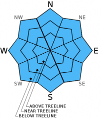
The avalanche danger should remain LOW today for all aspects and elevations. LOW danger does not mean no danger and unlikely does not mean impossible. Some small, shallow, isolated areas of unstable snow could still exist on some isolated terrain features. Continue to practice safe travel habits and thoughtful decision making when traveling in the backcountry.

1. Low

?

Above Treeline
Generally safe avalanche conditions. Watch for unstable snow on isolated terrain features.

1. Low

?

Near Treeline
Generally safe avalanche conditions. Watch for unstable snow on isolated terrain features.

1. Low

?

Below Treeline
Generally safe avalanche conditions. Watch for unstable snow on isolated terrain features.
    Generally safe avalanche conditions. Watch for unstable snow on isolated terrain features.
Avalanche Problem 1: Normal Caution
  • Type ?
  • Aspect/Elevation ?
  • Likelihood ?
    Certain
    Very Likely
    Likely
    Possible
    Unlikely
  • Size ?
    Historic
    Very Large
    Large
    Small

Avalanche activity remains unlikely today. Some small, isolated wet snow insatbilities like pinwheels, roller balls or wet loose sluffs may form on all aspects today due to daytime warming and the increase in cloud cover. The clouds will act as an insulating blanket that will prevent the snowpack from cooling itself with radiational cooling and allow today's warmth spread to northerly aspects. If some rain does actually fall on the snowpack, wet snow instabilities may become more widespread.

Some small, isolated areas of potentially unstable wind slabs that may still linger in near and above treeline terrain represent the other unlikely and mostly benign issue. In the few areas where these slabs might remain, they should also have become difficult to trigger. In the unlikely event that a person did find a human-triggereable wind slab, it should not invovle enough snow to do much more than knock a person down or push a person off his/her intended course. In most areas this issue would represent more an inconvinence than an actual problem unless it occurs in areas that magnify the consequences of any size avalanche or where any stumble or fall can have serious consequences. These kind of places include steep couliors, slopes above cliffs, and other complex or extreme terrain.

recent observations

Yesterday on Chickadee Ridge consistent cloud cover kept the snow surface from softening before noon on the typically sun-exposed southerly aspects. These surfaces likely did soften during the afternoon. On the northerly aspects 2-3 inches of soft snow existed above the old surface crusts. In most places this snow remained cold and dry, but patches of wet, sticky snow existed where patches of sunshine existed.

Below the soft surface snow on the northerly aspects, observations showed that the old crusts are eroding and softer layers of snow remained below these crusts. These layers feel soft and weak, but tests on these layers still indicated that if they do break, the resulting fracture is not likely to travel very far. This layer still needs to be watched and tracked to see what it changes into before the next storm because it still has potential to become a persistent weak layer.

Weather and CURRENT CONDITIONS
weather summary

Weak storm systems passing north of the forecast area this afternoon and evening should cause an increase in cloud cover and southwest winds. A small chance for some isolated rain showers also exists in the northern part of the forecast area. Temperatures should remain warm with daytime highs in the upper 30's to upper 40's above 7000 ft, and snow levels should remain between 8000 and 9000 ft. A high pressure ridge should start to rebuild over the area tomorrow afternoon and skies should begin to clear. 

CONDITIONS ALONG THE SIERRA CREST BETWEEN 8200 FT. AND 9200 FT. IN THE LAST 24 HOURS
6am temperature: 32 to 40 deg. F.
Max. temperature: 47 to 52 deg. F.
Average ridgetop wind direction: Southwest
Average ridgetop wind speed: 15 mph
Maximum ridgetop wind gust: 41 mph
New snowfall: 0 inches
Total snow depth: 23 to 32 inches
Two-Day Mountain Weather Forecast Produced in partnership with the Reno NWS
For 7000 ft. to 8000 ft.
Monday Monday Night Tuesday
Weather: Partly cloudy becoming mostly cloudy with a slight chance of isolated showers Mostly cloudy with a slight chance of isolated showers Mostly cloudy
Temperatures: 44 to 51 deg. F. 33 to 37 deg. F. 45 to 52 deg. F.
Mid Slope Winds: Southwest West Southwest
Wind Speed: 10 to 20 mph with gusts to 30 mph 10 to 20 mph with gusts to 35 mph 15 to 25 mph with gusts to 40 mph
Expected snowfall: 0 0 0
For 8000 ft. to 9000 ft.
Monday Monday Night Tuesday
Weather: Partly cloudy becoming mostly cloudy with a slight chance of isolated showers Mostly cloudy with a slight chance of isolated showers Mostly cloudy
Temperatures: 38 to 44 deg. F. 28 to 34 deg. F. 38 to 44 deg. F.
Ridge Top Winds: Southwest West shifting to the southwest Southwest
Wind Speed: 20 to 30 mph with gusts to 45 mph 15 to 25 mph with gusts to 35 mph increasing to 20 to 35 mph with gusts to 55 mph after midnight 25 to 40 mph with gusts to 60 mph
Expected snowfall: 0 0 0
Disclaimer

This avalanche advisory is provided through a partnership between the Tahoe National Forest and the Sierra Avalanche Center. This advisory covers the Central Sierra Nevada Mountains between Yuba Pass on the north and Ebbetts Pass on the south. Click here for a map of the forecast area. This advisory applies only to backcountry areas outside established ski area boundaries. This advisory describes general avalanche conditions and local variations always occur. This advisory expires 24 hours after the posted time unless otherwise noted. The information in this advisory is provided by the USDA Forest Service who is solely responsible for its content.