THIS AVALANCHE FORECAST EXPIRED ON February 26, 2015 @ 6:44 am
Avalanche Forecast published on February 25, 2015 @ 6:44 am
Issued by Brandon Schwartz - Tahoe National Forest

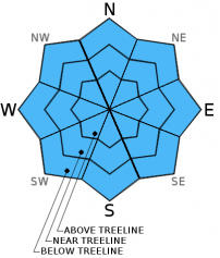
Avalanche danger remains LOW for all elevations and aspects. Areas of wet surface snow that form today are not expected to pose a significant hazard to backcountry travelers. Normal caution is advised.

1. Low

?

Above Treeline
Generally safe avalanche conditions. Watch for unstable snow on isolated terrain features.

1. Low

?

Near Treeline
Generally safe avalanche conditions. Watch for unstable snow on isolated terrain features.

1. Low

?

Below Treeline
Generally safe avalanche conditions. Watch for unstable snow on isolated terrain features.
    Generally safe avalanche conditions. Watch for unstable snow on isolated terrain features.
Avalanche Problem 1: Normal Caution
  • Type ?
  • Aspect/Elevation ?
  • Likelihood ?
    Certain
    Very Likely
    Likely
    Possible
    Unlikely
  • Size ?
    Historic
    Very Large
    Large
    Small

Avalanche concerns for today are minimal. Despite air temperatures remaining above freezing in most mid and upper elevation areas last night, a decent overnight snow surface refreeze is expected to have occurred due to radiational cooling under clear skies. Areas of surface wet snow are expected to form in response to daytime warming on E-SE-S-SW-W aspects. Snow surface conditions are expected to remain supportable well into the afternoon hours. Any areas of loose wet snow instability that form this afternoon are expected to remain small and shallow, not posing a significant hazard to backcountry travelers.

recent observations

Observations made yesterday on Red Vista/Elephant's Hump (Carson Pass area) and on Tamarack Peak (Mount Rose area) matched well with other recent observations from around the forecast area indicating stable snowpack conditions. Well established melt-freeze conditions exist on top of a well consolidated and well bonded snowpack in the majority of areas. The notable exception is isolated areas of near surface facets up to 15 cm thick at the snow surface sitting on top of high density rain crust. These facets have been observed in near treeline and below treeline terrain on NW-N-NE aspects that have at least some shade and moderate protection from NE winds. Without an overlying slab, these near surface facets are not a stability concern for today. They will however become a layer to keep an eye on if new snow loading occurs this weekend as is currently forecast.

Weather and CURRENT CONDITIONS
weather summary

The warmest day of the week is expected today before a weak cold front moves through the region tonight and storm systems approach the region on Friday. For today expect sunny skis this morning with building thin mid to high level cloud cover this afternoon. An air temperature inversion set up last night with remote sensors between 8,000' and 9,600' reporting air temperatures in the low to mid 30s this morning and air temperatures in the 20s on the mountain valley floors. Maximum daytime air temperatures are forecast to reach the mid to upper 40s today for areas above 7,000'. Ridgetop winds became light yesterday afternoon and remain light out of the northeast this morning. Ridgetop winds are expected to increase to moderate speed out of the north to northwest as the day progresses with gusts up to 45 mph. For tomorrow expect around 5 degrees of cooling as compared to today and continued moderate speed ridgetop winds.

CONDITIONS ALONG THE SIERRA CREST BETWEEN 8200 FT. AND 9200 FT. IN THE LAST 24 HOURS
6am temperature: 31 to 37 deg. F.
Max. temperature: 46 to 50 deg. F.
Average ridgetop wind direction: Northeast
Average ridgetop wind speed: Prior to 2 pm: 30 mph | Since 2 pm: 8 mph
Maximum ridgetop wind gust: Prior to 2 pm: 53 mph | Since 2 pm: 18 mph
New snowfall: 0 inches
Total snow depth: 26 to 43 inches
Two-Day Mountain Weather Forecast Produced in partnership with the Reno NWS
For 7000 ft. to 8000 ft.
Wednesday Wednesday Night Thursday
Weather: Sunny skies this morning becoming partly cloudy this afternoon. Partly cloudy skies. Partly cloudy skies.
Temperatures: 43 to 50 deg. F. 24 to 30 deg. F. 38 to 45 deg. F.
Mid Slope Winds: NW W N
Wind Speed: 15 to 20 mph Light winds becoming 10 to 15 mph with gusts to 25 mph after midnight. 15 to 20 mph with gusts to 30 mph.
Expected snowfall: 0 0 0
For 8000 ft. to 9000 ft.
Wednesday Wednesday Night Thursday
Weather: Sunny skies this morning becoming partly cloudy this afternoon. Partly cloudy skies. Partly cloudy skies.
Temperatures: 42 to 48 deg. F. 18 to 25 deg. F. 37 to 43 deg. F.
Ridge Top Winds: N NE shifting to W after midnight. N
Wind Speed: 20 to 30 mph with gusts to 45 mph. 10 to 15 mph with gusts to 25 mph, shifting and increasing to 20 to 25 mph with gusts to 35 mph after midnight. 20 to 30 mph. Gusts to 50 mph decreasing to 30 mph in the afternoon.
Expected snowfall: 0 0 0
Disclaimer

This avalanche advisory is provided through a partnership between the Tahoe National Forest and the Sierra Avalanche Center. This advisory covers the Central Sierra Nevada Mountains between Yuba Pass on the north and Ebbetts Pass on the south. Click here for a map of the forecast area. This advisory applies only to backcountry areas outside established ski area boundaries. This advisory describes general avalanche conditions and local variations always occur. This advisory expires 24 hours after the posted time unless otherwise noted. The information in this advisory is provided by the USDA Forest Service who is solely responsible for its content.