THIS AVALANCHE FORECAST EXPIRED ON February 5, 2015 @ 6:47 am
Avalanche Forecast published on February 4, 2015 @ 6:47 am
Issued by Andy Anderson - Tahoe National Forest - Sierra Avalanche Center

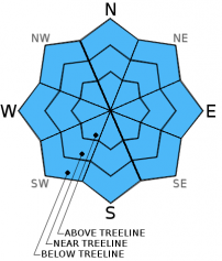
The avalanche danger should remain LOW for all aspects and elevations today. Continue to practice safe travel habits and thoughtful decision making when traveling in the backcountry.

1. Low

?

Above Treeline
Generally safe avalanche conditions. Watch for unstable snow on isolated terrain features.

1. Low

?

Near Treeline
Generally safe avalanche conditions. Watch for unstable snow on isolated terrain features.

1. Low

?

Below Treeline
Generally safe avalanche conditions. Watch for unstable snow on isolated terrain features.
    Generally safe avalanche conditions. Watch for unstable snow on isolated terrain features.
Avalanche Problem 1: Normal Caution
  • Type ?
  • Aspect/Elevation ?
  • Likelihood ?
    Certain
    Very Likely
    Likely
    Possible
    Unlikely
  • Size ?
    Historic
    Very Large
    Large
    Small

Avalanche activity will remain unlikely today. Data and observations indicate that the recent snow has consolidated and bonded to the old snow surfaces in most areas. Some small isolated wet snow instabilities may occur today as the day warms up. These should remain small and limited due to a decent overnight refreeze, a snowpack with well established drainage, today's strong winds, some cloud cover, and the weak winter sun all working to prevent larger more widespread wet snow instabilities from forming.

While avalanche activity will remain unlikely today, the thin coverage in many areas and early season conditions present other hazards including lots of exposed obstacles to hit.

recent observations

Yesterday on Castle Peak, a thin rain crust existed on most northerly aspects. Underneath this crust the most recent 2-3 inches of snow remained wet from the previous day's rain event. Below this wet snow, the old crusts remained frozen, but the layer of softer snow below those crusts had become moist and completely rounded. It readily clumped together when squeezed and bonding between the now rounded snow grains was visible upon magnification.

On sun-exposed S-SW aspects, numerous rocks and areas of bare ground have melted out as snow coverage has become sparse. In areas where snow cover still remained on these aspects, 2-3 inches of soft corn snow formed above a supportable base by noon.

Weather and CURRENT CONDITIONS
weather summary

A high pressure ridge over the region should allow daytime highs to climb into the upper 40's and low 50's above 7000 ft. today and tomorrow. Some high clouds should move into the area today and tomorrow as well. While the high pressure will keep the temperatures warm and the skies partly cloudy to mostly sunny today and tomorrow, the southwest winds will continue to increase ahead of the approaching storm system. By tomorrow afternoon wind speeds along the Sierra ridgelines could average in the 50 to 65 mph range with gusts to 100 mph. For the latest details concerning the upcoming storm check in with the Reno NWS.

CONDITIONS ALONG THE SIERRA CREST BETWEEN 8200 FT. AND 9200 FT. IN THE LAST 24 HOURS
6am temperature: 34 to 41 deg. F.
Max. temperature: 42 to 50 deg. F.
Average ridgetop wind direction: West and Southwest
Average ridgetop wind speed: 25 to 35 mph
Maximum ridgetop wind gust: 69 mph
New snowfall: 0 inches
Total snow depth: 21 to 32 inches
Two-Day Mountain Weather Forecast Produced in partnership with the Reno NWS
For 7000 ft. to 8000 ft.
Wednesday Wednesday Night Thursday
Weather: Partly cloudy Mostly clear Partly cloudy
Temperatures: 48 to 54 deg. F. 33 to 37 deg. F. 47 to 53 deg. F.
Mid Slope Winds: Southwest Southwest Southwest
Wind Speed: 15 to 30 mph with gusts to 40 mph 20 to 35 mph with gusts to 50 mph 25 to 40 mph with gusts to 70 mph
Expected snowfall: 0 0 0
For 8000 ft. to 9000 ft.
Wednesday Wednesday Night Thursday
Weather: Partly cloudy Mostly clear Partly cloudy
Temperatures: 43 to 50 deg. F. 29 to 35 deg. F. 42 to 49 deg. F.
Ridge Top Winds: Southwest Southwest Southwest
Wind Speed: 30 to 45 mph with gusts to 70 mph 40 to 55 mph with gusts to 85 mph 45 to 55 mph with gusts to 85 mph increasing to 50 to 65 mph with gusts to 100 mph in the afternoon
Expected snowfall: 0 0 0
Disclaimer

This avalanche advisory is provided through a partnership between the Tahoe National Forest and the Sierra Avalanche Center. This advisory covers the Central Sierra Nevada Mountains between Yuba Pass on the north and Ebbetts Pass on the south. Click here for a map of the forecast area. This advisory applies only to backcountry areas outside established ski area boundaries. This advisory describes general avalanche conditions and local variations always occur. This advisory expires 24 hours after the posted time unless otherwise noted. The information in this advisory is provided by the USDA Forest Service who is solely responsible for its content.