THIS AVALANCHE FORECAST EXPIRED ON January 11, 2015 @ 6:59 am
Avalanche Forecast published on January 10, 2015 @ 6:59 am
Issued by Andy Anderson - Tahoe National Forest - Sierra Avalanche Center

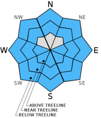
LOW avalanche danger exists on all elevations and aspects. Some isolated and minor wet snow instabilities may form today due to a weak overnight refreeze and the slight possibility of rain on snow. Continue to practice safe travel habits and thoughtful decision making when traveling in the backcountry.

1. Low

?

Above Treeline
Generally safe avalanche conditions. Watch for unstable snow on isolated terrain features.

1. Low

?

Near Treeline
Generally safe avalanche conditions. Watch for unstable snow on isolated terrain features.

1. Low

?

Below Treeline
Generally safe avalanche conditions. Watch for unstable snow on isolated terrain features.
    Generally safe avalanche conditions. Watch for unstable snow on isolated terrain features.
Avalanche Problem 1: Loose Wet
  • Type ?
  • Aspect/Elevation ?
  • Likelihood ?
    Certain
    Very Likely
    Likely
    Possible
    Unlikely
  • Size ?
    Historic
    Very Large
    Large
    Small

The limited melting and softening that did occur yesterday may not have refrozen very well last night due to overnight cloud cover and warm nighttime temperatures. In spite of this weak overnight refreeze, significant wet snow instabilities should remain unlikely because today's cooler temperatures and continued cloud cover will mean less daytime warming and less melting. Some small roller balls, pinwheels, or small wet snow sluffs may occur on mid to lower elevation northerly aspects where the surface snow started to warm up for the first time yesterday and did not refreeze overnight. Some of the southerly aspects may soften today if they receive any direct sunshine. If any rain showers actually occur small wet snow instabilities may become possible on slopes that receive rain.

recent observations

Yesterday on Red Lake Peak most areas remained cold and and frozen above 8400 ft. Northerly aspects above this elevation held a mix of firm surfaces and breakable crusts in exposed areas and well consolidated softer snow in sheltered areas. Below 8400 ft. on the northerly aspects, some surface warming occurred due to the widespread cloud cover and produced wet sticky surface snow. Firm melt-freeze conditions existed on exposed aspects facing the southern half of the compass above 8000 ft. Below 8000 ft. on the southerly aspects some minimal surface melting did occur.

Snowpit data revealed that a weak layer continues to form in the snowpack around the uppermost rain crust. Tests on this layer still indicate that it does not pose much of a problem right now, but that if a slab forms above it in the future it could become reactive.

Weather and CURRENT CONDITIONS
weather summary

A series of weak low pressure systems will allow for for continued cloud cover, slightly cooler temperatures, and a slight chance of rain and snow through the weekend. The predicted showers will remain light and produce little to no accumulation. Today snow levels should remain between 7000 and 8000 ft. During the night temperatures and snow levels should decrease. The forecast also calls for slightly cooler temperatures tomorrow. Winds should remain light and variable until tomorrow afternoon when they shift to the west and southwest and increase ahead of a slightly stronger low pressure system moving in from the north. 

CONDITIONS ALONG THE SIERRA CREST BETWEEN 8200 FT. AND 9200 FT. IN THE LAST 24 HOURS
6am temperature: 34 to 39 deg. F.
Max. temperature: 41 to 45 deg. F.
Average ridgetop wind direction: Southwest to northwest
Average ridgetop wind speed: 10 to 15 mph
Maximum ridgetop wind gust: 26 mph
New snowfall: 0 inches
Total snow depth: 24 to 35 inches
Two-Day Mountain Weather Forecast Produced in partnership with the Reno NWS
For 7000 ft. to 8000 ft.
Saturday Saturday Night Sunday
Weather: Mostly cloudy with a slight chance of showers. Snow levels 7000-8000 ft. Mostly cloudy with a slight chance of showers. Snow levels 5500-6500 ft. Mostly cloudy with a slight chance of showers. Snow levels 6000-7000 ft.
Temperatures: 38 to 45 deg. F. 22 to 29 deg. F. 34 to 41 deg. F.
Mid Slope Winds: Variable Variable Variable becoming southwest in the afternoon
Wind Speed: Light Light Light becoming 10 to 15 mph with gusts to 25 mph in the afternoon
Expected snowfall: 0 0 0
For 8000 ft. to 9000 ft.
Saturday Saturday Night Sunday
Weather: Mostly cloudy with a slight chance of snow showers Mostly cloudy with a slight chance of snow showers Mostly cloudy with a slight chance of snow showers
Temperatures: 39 to 45 deg. F. 21 to 28 deg. F. 35 to 41 deg. F.
Ridge Top Winds: Variable Variable becoming southwest after midnight Variable becoming west in the afternoon
Wind Speed: Light Light becoming 10 to 15 mph after midnight Light becoming 25 to 35 mph with gusts to 40 mph in the afternoon
Expected snowfall: 0 0 0
Disclaimer

This avalanche advisory is provided through a partnership between the Tahoe National Forest and the Sierra Avalanche Center. This advisory covers the Central Sierra Nevada Mountains between Yuba Pass on the north and Ebbetts Pass on the south. Click here for a map of the forecast area. This advisory applies only to backcountry areas outside established ski area boundaries. This advisory describes general avalanche conditions and local variations always occur. This advisory expires 24 hours after the posted time unless otherwise noted. The information in this advisory is provided by the USDA Forest Service who is solely responsible for its content.