THIS AVALANCHE FORECAST EXPIRED ON January 16, 2015 @ 6:32 am
Avalanche Forecast published on January 15, 2015 @ 6:32 am
Issued by Andy Anderson - Tahoe National Forest - Sierra Avalanche Center

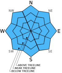
The avalanche danger remains LOW on all elevations and aspects. Continue to practice safe travel habits and thoughtful decision making when traveling in the backcountry.

1. Low

?

Above Treeline
Generally safe avalanche conditions. Watch for unstable snow on isolated terrain features.

1. Low

?

Near Treeline
Generally safe avalanche conditions. Watch for unstable snow on isolated terrain features.

1. Low

?

Below Treeline
Generally safe avalanche conditions. Watch for unstable snow on isolated terrain features.
    Generally safe avalanche conditions. Watch for unstable snow on isolated terrain features.
Avalanche Problem 1: Normal Caution
  • Type ?
  • Aspect/Elevation ?
  • Likelihood ?
    Certain
    Very Likely
    Likely
    Possible
    Unlikely
  • Size ?
    Historic
    Very Large
    Large
    Small

Avalanche activity will remain unlikely today. Sunshine and daytime warming should cause enough melting for some soft surface snow to form on the sun-exposed southerly aspects today. In spite of this warming, a decent overnight refreeze, well established drainage channels, the weak January sun, and increased winds will all help prevent significant wet snow instabilities from forming today.

On the northerly aspects, a poorly developed weak layer does exist below the uppermost rain crust in some areas. However, the snowpack lacks a key ingredient for avalanche activity because finding a slab above this weak layer in an area where a person could trigger a slab avalanche remains very unlikely. This layer does warrant continued monitoring to see what it becomes before the weather decides to add new snow above it.

recent observations

Yesterday observations on Elephant's Back showed mostly firm and scoured conditions on the northerly aspects with a few very small isolated patches of softer snow in sheltered places. On the sun-exposed southerly facing aspects, 1-2 inches of soft corn snow had formed above a supportable and frozen melt-freeze layer by 1 pm. Snowpit data, snowpit tests, and general observations did not reveal any signs of instabilities. Snowpit data indicated that the weak layer forming under the rain crusts in some other areas remained much less well developed here and that good bonding exists within that layer and between it and the snowpack layers above and below it.

Across Hwy 88 on Red Lake Peak, Caltrans was practicing with artillery explosives, and those charges did not reveal any signs of instability on the SE-S aspects on Red Lake Peak.

Weather and CURRENT CONDITIONS
weather summary

The winds have shifted to the southwest due to a weak low pressure moving across southern OR. This system should remain mostly north of the Tahoe area. It may push a few clouds into the region over the next 24 hours and could bring a slight chance for some very light precipitation to the northern part of the forecast area by tomorrow. The forecast calls for daytime highs above 7000 ft in the mid to upper 40's today and slightly cooler daytime highs tomorrow. Skies should remain mostly sunny today before some cloud cover moves into the region starting this evening.

CONDITIONS ALONG THE SIERRA CREST BETWEEN 8200 FT. AND 9200 FT. IN THE LAST 24 HOURS
6am temperature: 29 to 37 deg. F.
Max. temperature: 46 to 50 deg. F.
Average ridgetop wind direction: East to southwest
Average ridgetop wind speed: 10 to 15 mph
Maximum ridgetop wind gust: 44 mph
New snowfall: 0 inches
Total snow depth: 24 to 34 inches
Two-Day Mountain Weather Forecast Produced in partnership with the Reno NWS
For 7000 ft. to 8000 ft.
Thursday Thursday Night Friday
Weather: Mostly sunny with a few scattered clouds Partly cloudy Mostly cloudy with a slight chance of rain and snow in the northern part of the forecast area
Temperatures: 41 to 48 deg. F. 22 to 29 deg. F. 41 to 47 deg. F.
Mid Slope Winds: Southwest Southwest Southwest
Wind Speed: Light in the morning increasing to 10 to 15 mph with gusts to 25 mph in the afternoon 15 to 20 mph with gusts to 30 mph increasing to 25 to 30 mph with gusts to 50 mph after midnight 20 to 30 mph with gusts to 45 mph
Expected snowfall: 0 0 0
For 8000 ft. to 9000 ft.
Thursday Thursday Night Friday
Weather: Mostly sunny with a few scattered clouds Partly cloudy Mostly cloudy with a slight chance of snow in the northern part of the forecast area
Temperatures: 41 to 48 deg. F. 22 to 29 deg. F. 38 to 44 deg. F.
Ridge Top Winds: Southwest Southwest Southwest
Wind Speed: 15 to 25 mph with gusts up to 40 mph in the afternoon 25 to 30 mph with gusts to 40 mph increasing to 45 to 50 mph with gusts to 75 mph after midnight 40 to 50 mph with gusts to 75 mph
Expected snowfall: 0 0 0
Disclaimer

This avalanche advisory is provided through a partnership between the Tahoe National Forest and the Sierra Avalanche Center. This advisory covers the Central Sierra Nevada Mountains between Yuba Pass on the north and Ebbetts Pass on the south. Click here for a map of the forecast area. This advisory applies only to backcountry areas outside established ski area boundaries. This advisory describes general avalanche conditions and local variations always occur. This advisory expires 24 hours after the posted time unless otherwise noted. The information in this advisory is provided by the USDA Forest Service who is solely responsible for its content.