


For 7000 ft. to 8000 ft.
| Sunday | Sunday Night | Monday | |
|---|---|---|---|
| Weather: | Mostly cloudy skies. Isolated areas of light rain and snow, mainly north of I-80. Snow level 6,000' to 8,000'. | Mostly cloudy skies. | Mostly cloudy skies, becoming partly cloudy. |
| Temperatures: | 45 to 51 deg. F. | 22 to 29 deg. F. | 42 to 48 deg. F. |
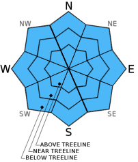
| Mid Slope Winds: | SW | SW | SW |
| Wind Speed: | 20 to 30 mph with gusts to 45 mph. | 25 to 30 mph with gusts to 45 mph, decreasing to 10 to 15 mph with gusts to 25 mph after midnight. | 10 to 15 mph with gusts to 25 mph in the morning, becoming light. |
| Expected snowfall: | 0 to trace | 0 | 0 |
For 8000 ft. to 9000 ft.
| Sunday | Sunday Night | Monday | |
|---|---|---|---|
| Weather: | Mostly cloudy skies. Isolated areas of snow showers, mainly north of I-80. | Mostly cloudy skies. | Mostly cloudy skies, becoming partly cloudy. |
| Temperatures: | 43 to 49 deg. F. | 23 to 30 deg. F. | 39 to 45 deg. F. |
| Ridge Top Winds: | SW | SW | SW |
| Wind Speed: | 35 to 45 mph with gusts to 70 mph. | 35 to 40 mph with gusts to 60 mph, decreasing to 20 to 25 mph with gusts to 40 mph after midnight. | 20 to 25 mph with gusts to 40 mph, decreasing to 10 to 15 mph with gusts to 25 mph in the afternoon. |
| Expected snowfall: | 0 to trace | 0 | 0 |


