THIS AVALANCHE FORECAST EXPIRED ON January 10, 2015 @ 7:00 am
Avalanche Forecast published on January 9, 2015 @ 7:00 am
Issued by Andy Anderson - Tahoe National Forest - Sierra Avalanche Center

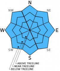
LOW avalanche danger exists on all elevations and aspects. Some isolated and minor wet snow instabilities may form today if any rain materializes this afternoon. Continue to practice safe travel habits and thoughtful decision making when traveling in the backcountry.

1. Low

?

Above Treeline
Generally safe avalanche conditions. Watch for unstable snow on isolated terrain features.

1. Low

?

Near Treeline
Generally safe avalanche conditions. Watch for unstable snow on isolated terrain features.

1. Low

?

Below Treeline
Generally safe avalanche conditions. Watch for unstable snow on isolated terrain features.
    Generally safe avalanche conditions. Watch for unstable snow on isolated terrain features.
Avalanche Problem 1: Normal Caution
  • Type ?
  • Aspect/Elevation ?
  • Likelihood ?
    Certain
    Very Likely
    Likely
    Possible
    Unlikely
  • Size ?
    Historic
    Very Large
    Large
    Small

Slightly cooler temperatures and increasing cloud cover forecasted for today mean less daytime warming and less wet snow. Some of the southerly aspects may still soften today if they receive direct sunshine, but significant wet snow instabilities remain unlikely. Later this afternoon as a chance for some rain showers develops, some wet snow instabilities like roller balls, pinwheels, or minor wet snow sluffs may become possible if any slopes actually receive any rain.

recent observations

Yesterday on the sun-exposed slopes on the south side of Castle Peak, the snow surface softened during the morning, and 1-3 inches of soft corn snow existed on top of a supportable base by 11 am up to at least 8500 ft. By 11:30 am 10 to 12 inches of wet, sticky, and less supportable snow existed on sun exposed S-SW aspects at 7600 ft. In the shaded areas and on the non-southerly aspects the snow surface remained cold and frozen.

Weather and CURRENT CONDITIONS
weather summary

Some cloud cover has moved into the area ahead of a small, weak, and disorganized low pressure system. Mostly cloudy skies and slightly cooler temperatures represent the main effects associated with this system, but a slight chance for some rain and snow showers that produce little to no accumulation does exist starting this afternoon and continuing through tomorrow. Areas south of Hwy 50 have the best chances for receiving some precipitation. The forecast calls for freezing levels around 8000 to 8500 ft today and 7000 to 7500 ft. tomorrow. Winds accompanying this system should remain light.

CONDITIONS ALONG THE SIERRA CREST BETWEEN 8200 FT. AND 9200 FT. IN THE LAST 24 HOURS
6am temperature: 33 to 42 deg. F.
Max. temperature: 44 to 50 deg. F.
Average ridgetop wind direction: Southwest
Average ridgetop wind speed: 10 mph
Maximum ridgetop wind gust: 35 mph
New snowfall: 0 inches
Total snow depth: 24 to 36 inches
Two-Day Mountain Weather Forecast Produced in partnership with the Reno NWS
For 7000 ft. to 8000 ft.
Friday Friday Night Saturday
Weather: Mostly cloudy with a slight chance of showers in the afternoon. Freezing level 8000-8500 ft. Mostly cloudy Mostly cloudy with a slight chance of showers especially south of Hwy. 50. Freezing level 7000-7500 ft.
Temperatures: 42 to 49 deg. F. 27 to 33 deg. F. 37 to 44 deg. F.
Mid Slope Winds: Variable Variable Variable
Wind Speed: Light Light Light
Expected snowfall: 0 0 0
For 8000 ft. to 9000 ft.
Friday Friday Night Saturday
Weather: Mostly cloudy with a slight chance of showers in the afternoon. Freezing level 8000-8500 ft. Mostly cloudy Mostly cloudy with a slight chance of showers especially south of Hwy. 50.
Temperatures: 39 to 46 deg. F. 24 to 31 deg. F. 34 to 41 deg. F.
Ridge Top Winds: Variable Variable West
Wind Speed: Light Light Light increasing to 10 to 15 mph in the afternoon
Expected snowfall: 0 0 0
Disclaimer

This avalanche advisory is provided through a partnership between the Tahoe National Forest and the Sierra Avalanche Center. This advisory covers the Central Sierra Nevada Mountains between Yuba Pass on the north and Ebbetts Pass on the south. Click here for a map of the forecast area. This advisory applies only to backcountry areas outside established ski area boundaries. This advisory describes general avalanche conditions and local variations always occur. This advisory expires 24 hours after the posted time unless otherwise noted. The information in this advisory is provided by the USDA Forest Service who is solely responsible for its content.