THIS AVALANCHE FORECAST EXPIRED ON March 19, 2015 @ 6:43 am
Avalanche Forecast published on March 18, 2015 @ 6:43 am
Issued by Andy Anderson - Tahoe National Forest - Sierra Avalanche Center

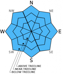
This morning the avalanche danger is LOW due to a solid overnight refreeze. By this afternoon pockets of MODERATE danger could form on isolated SE-S-SW-W aspects that still have snow, sun-exposed E aspects, and slopes on any aspects that actually receive rain today. Daytime warming and a chance of isolated rain showers may allow enough wet snow to form in these areas for small human triggered loose wet avalanches to become possible on slopes 37 degrees and steeper.

2. Moderate

?

Above Treeline
Heightened avalanche conditions on specific terrain features. Evaluate snow and terrain carefully; identify features of concern.

2. Moderate

?

Near Treeline
Heightened avalanche conditions on specific terrain features. Evaluate snow and terrain carefully; identify features of concern.

2. Moderate

?

Below Treeline
Heightened avalanche conditions on specific terrain features. Evaluate snow and terrain carefully; identify features of concern.
    Heightened avalanche conditions on specific terrain features. Evaluate snow and terrain carefully; identify features of concern.
Avalanche Problem 1: Loose Wet
  • Type ?
  • Aspect/Elevation ?
  • Likelihood ?
    Certain
    Very Likely
    Likely
    Possible
    Unlikely
  • Size ?
    Historic
    Very Large
    Large
    Small

Last night's colder temperatures and clear skies should have allowed the snowpack to undergo a strong refreeze for the first time in several days. A lack of snow on most SE-S-SW-W aspects, the stronger overnight refreeze, the cooling effects of the light east winds, and the existence of well established drainage channels that allow water to efficiently exit the snowpack should all work together to keep large widespread wet snow instabilities at bay today. On the other hand, the March sunshine and warmer temperatures may create enough wet snow for some small loose wet snow instabilities to form on the E aspects and on the isolated SE-S-SW-W aspects where snow does remain. Some wet snow instabilities may also form on isolated NW-N-NE aspects if they receive rain today. However, most of the northerly aspects should not experience enough warming for significant wet snow to form since the rain/thunderstorms should remain scattered and isolated.

recent observations

Yesterday on Castle Peak and Andesite Ridge evidence of a refreeze existed during the morning. N and NE aspects held a frozen surface crust with 1-2 ft of wet snow below it. E aspects held similar conditions before 10 am. This refreeze had already started to melt away by 10:30 am. By noon unsupportable wet snow up to 18 inches deep had formed on some E aspects while other E aspects held a few inches of corn snow on top of a melt freeze crust that could still support a skier. Exposed ground dominates the SE-S-SW-W aspects where only a few small patches of snow remain. The NW-N-NE-E aspects still hold decent snow coverage.

Weather and CURRENT CONDITIONS
weather summary

Skies cleared last night and temperatures dropped into the mid 20's to low 30's in the mountains. Skies should remain partly sunny to partly cloudy today as a low pressure south of the area provides some moisture and instability over the region. This instability and moisture will also allow for a chance of afternoon thunderstorms today. Since temperatures should remain warm, any precipitation that does fall in isolated areas should fall as rain below 9000 ft. with a slight chance for some snow down to 8000 ft. Tonight the low pressure moves farther away from the area, and another high pressure ridge settles over the region. The forecast calls for clear skies tonight and tomorrow with daytime highs climbing back into the mid 50's above 7000 ft. tomorrow. Winds should remain light and out of the east today and tomorrow.

CONDITIONS ALONG THE SIERRA CREST BETWEEN 8200 FT. AND 9200 FT. IN THE LAST 24 HOURS
6am temperature: 29 to 33 deg. F.
Max. temperature: 40 to 46 deg. F.
Average ridgetop wind direction: Southwest shifting to east after midnight
Average ridgetop wind speed: 15 mph
Maximum ridgetop wind gust: 46 mph
New snowfall: 0 inches
Total snow depth: 21 to 41 inches
Two-Day Mountain Weather Forecast Produced in partnership with the Reno NWS
For 7000 ft. to 8000 ft.
Wednesday Wednesday Night Thursday
Weather: Mostly sunny to partly cloudy with a chance of isolated thunderstorms in the afternoon Partly cloudy with a slight chance of evening thunderstorms becoming clear overnight Sunny
Temperatures: 45 to 52 deg. F. 24 to 31 deg. F. 51 to 58 deg. F.
Mid Slope Winds: Variable East Variable
Wind Speed: Light 0 to 5 mph increasing to 10 to 15 mph after midnight Light
Expected snowfall: 0 0 0
For 8000 ft. to 9000 ft.
Wednesday Wednesday Night Thursday
Weather: Mostly sunny to partly cloudy with a chance of isolated thunderstorms in the afternoon Partly cloudy with a slight chance of evening thunderstorms becoming clear overnight Sunny
Temperatures: 45 to 51 deg. F. 24 to 31 deg. F. 46 to 53 deg. F.
Ridge Top Winds: East Northeast East
Wind Speed: 10 to 15 mph with gusts to 25 mph in the morning becoming light during the day 15 to 20 mph with gusts to 30 mph after midnight 10 to 15 mph with gusts to 25 mph
Expected snowfall: 0 0 0
Disclaimer

This avalanche advisory is provided through a partnership between the Tahoe National Forest and the Sierra Avalanche Center. This advisory covers the Central Sierra Nevada Mountains between Yuba Pass on the north and Ebbetts Pass on the south. Click here for a map of the forecast area. This advisory applies only to backcountry areas outside established ski area boundaries. This advisory describes general avalanche conditions and local variations always occur. This advisory expires 24 hours after the posted time unless otherwise noted. The information in this advisory is provided by the USDA Forest Service who is solely responsible for its content.