THIS AVALANCHE FORECAST EXPIRED ON March 27, 2015 @ 6:43 am
Avalanche Forecast published on March 26, 2015 @ 6:43 am
Issued by Brandon Schwartz - Tahoe National Forest

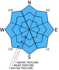
Avalanche danger is LOW for all elevations and aspects. Minor loose wet instabilities are expected during the afternoon hours. Loose wet avalanches large enough to bury or injure a person are unlikely. Normal caution is advised. Sufficient snow cover for avalanche activity on SE-S-SW-W aspects exists only in isolated portions of the forecast area. Much deeper, continuous snow cover exists on NW-N-NE-E aspects.

1. Low

?

Above Treeline
Generally safe avalanche conditions. Watch for unstable snow on isolated terrain features.

1. Low

?

Near Treeline
Generally safe avalanche conditions. Watch for unstable snow on isolated terrain features.

1. Low

?

Below Treeline
Generally safe avalanche conditions. Watch for unstable snow on isolated terrain features.
    Generally safe avalanche conditions. Watch for unstable snow on isolated terrain features.
Avalanche Problem 1: Loose Wet
  • Type ?
  • Aspect/Elevation ?
  • Likelihood ?
    Certain
    Very Likely
    Likely
    Possible
    Unlikely
  • Size ?
    Historic
    Very Large
    Large
    Small

With clear skies overnight and near freezing air temperatures, a decent to strong overnight snow surface refreeze is expected to have occurred due to radiational cooling. As daytime warming progresses, areas of surface wet snow will form on sun exposed slopes. Little to no snow cover remains on the vast majority of SE-S-SW-W aspects. Instability concerns on these aspects are confined to highly localized areas where snow cover actually exists. E aspects continue to hold significant snow cover around the vast majority of the forecast area. Surface wet snow several inches deep will exist on E aspects by this afternoon. Sun angles are still not quite high enough to create large amounts of snow surface melt on NW-N-NE aspects 35 degrees and steeper. As a result, a lesser degree of surface wet snow formation will exist on steep northerly aspects today. With free water drainage well established on all aspects, wet snow instability is expected to be limited to human triggered roller balls and human triggered loose wet sluffs in steep terrain that require a push to set into motion. Loose wet avalanches large enough to bury or injure a person are unlikely today. Keep in mind that terrain traps such as gullies and cliffs below can greatly magnify the consequences of very small avalanches that would otherwise be too small to bury or injure a person.

recent observations

Observations made yesterday on Red Vista/Elephant's Hump (Carson Pass area) revealed limited signs of surface wet snow instability in the area at mid day. Recent new snow was capped by melt-freeze crust on N aspects, rapidly assimilating with older melt-freeze crusts on E aspects, and rapidly melting out on SE-S-SW aspects. Snowpit data collected on a N aspect at 8,840' in near treeline terrain yielded no indications of slab instability. Skier triggered roller balls that occurred at noon on an open, sun exposed NE aspect reached 18 inches in diameter before breaking apart. Ski cuts on several steep N-NE-E aspects produced only roller balls and pinwheels, but no loose wet sluffs. Natural roller balls, likely having occurred on Tuesday were visible on the E face of Elephant's Back.

Weather and CURRENT CONDITIONS
weather summary

High pressure over the forecast area will provide sunny skies and above average air temperatures across the region today and tomorrow. Remote sensors are reporting air temperatures this morning in the low to upper 30s for areas 7,000' to 9,600'. Air temperature inversion conditions are minimal again this morning with 20s and 30s on the mountain valley floors. Maximum daytime air temperatures are forecast to reach the mid 50s to low 60s today for areas above 7,000'. Ridgetop winds remain moderate in speed out of the east this morning and are expected to become light in speed this afternoon. Southwest winds tomorrow will mix the atmosphere and drop maximum daytime air temperatures at the mid and upper elevations by a couple of degrees while the lower elevations continue to warm.

CONDITIONS ALONG THE SIERRA CREST BETWEEN 8200 FT. AND 9200 FT. IN THE LAST 24 HOURS
6am temperature: 33 to 40 deg. F.
Max. temperature: 47 to 51 deg. F.
Average ridgetop wind direction: East
Average ridgetop wind speed: 24 mph
Maximum ridgetop wind gust: 40 mph
New snowfall: 0 inches
Total snow depth: 15 to 40 inches
Two-Day Mountain Weather Forecast Produced in partnership with the Reno NWS
For 7000 ft. to 8000 ft.
Thursday Thursday Night Friday
Weather: Sunny skies. Clear skies. Sunny skies.
Temperatures: 55 to 62 deg. F. 30 to 37 deg. F. 54 to 61 deg. F.
Mid Slope Winds: E Variable SW
Wind Speed: 15 to 20 mph with gusts to 30 mph in the morning, becoming light. Light winds 15 to 20 mph. Gusts up to 30 mph in the afternoon.
Expected snowfall: 0 0 0
For 8000 ft. to 9000 ft.
Thursday Thursday Night Friday
Weather: Sunny skies. Clear skies. Sunny skies.
Temperatures: 54 to 60 deg. F. 31 to 38 deg. F. 52 to 58 deg. F.
Ridge Top Winds: E Variable SW
Wind Speed: 15 to 20 mph with gusts to 30 mph in the morning, becoming light. Light winds 10 to 15 mph with gusts to 25 mph, increasing to 20 to 25 mph with gusts to 35 mph in the afternoon.
Expected snowfall: 0 0 0
Disclaimer

This avalanche advisory is provided through a partnership between the Tahoe National Forest and the Sierra Avalanche Center. This advisory covers the Central Sierra Nevada Mountains between Yuba Pass on the north and Ebbetts Pass on the south. Click here for a map of the forecast area. This advisory applies only to backcountry areas outside established ski area boundaries. This advisory describes general avalanche conditions and local variations always occur. This advisory expires 24 hours after the posted time unless otherwise noted. The information in this advisory is provided by the USDA Forest Service who is solely responsible for its content.