THIS AVALANCHE FORECAST EXPIRED ON March 5, 2015 @ 6:50 am
Avalanche Forecast published on March 4, 2015 @ 6:50 am
Issued by Andy Anderson - Tahoe National Forest - Sierra Avalanche Center

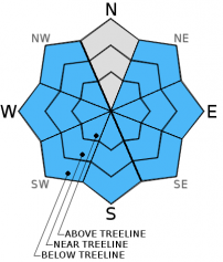
Avalanche danger remains LOW for all elevations and aspects. Remember LOW danger means that areas of unstable snow can still exist on isolated terrain features. Even though human triggered avalanches are unlikely, they are not impossible. Watch for small loose wet snow instabilities on sun exposed slopes and isolated, small, unlikely wind slabs in more extreme terrain.

1. Low

?

Above Treeline
Generally safe avalanche conditions. Watch for unstable snow on isolated terrain features.

1. Low

?

Near Treeline
Generally safe avalanche conditions. Watch for unstable snow on isolated terrain features.

1. Low

?

Below Treeline
Generally safe avalanche conditions. Watch for unstable snow on isolated terrain features.
    Generally safe avalanche conditions. Watch for unstable snow on isolated terrain features.
Avalanche Problem 1: Loose Wet
  • Type ?
  • Aspect/Elevation ?
  • Likelihood ?
    Certain
    Very Likely
    Likely
    Possible
    Unlikely
  • Size ?
    Historic
    Very Large
    Large
    Small

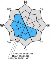
Warmer daytime highs and clear sunny skies should provide enough heat for some wet loose snow instabilities to form on any sun exposed slopes steeper than 37 degrees today. Roller balls and pinwheels should represent most of the loose wet snow instabilities that form today, but some small loose wet avalanches may also become possible on the most sun exposed aspects. These instabilities may not involve enough snow to bury a person, but they could push someone off course or knock a person over. Areas below 8000 ft. hold the best potential for loose wet instabilities since they should experience more warming, but sun-exposed slopes at the higher elevations may also see enough warming for some wet snow instabilities. Larger loose wet avalanches and wet slab avalanches will remain unlikely, but they are not impossible on slopes that undergo the most warming.

Avalanche Problem 2: Wind Slab
  • Type ?
  • Aspect/Elevation ?
  • Likelihood ?
    Certain
    Very Likely
    Likely
    Possible
    Unlikely
  • Size ?
    Historic
    Very Large
    Large
    Small

Wind slabs have become unlikely. Unlikely does not mean impossible, and some small isolated wind slabs may still linger in complex or extreme terrain especially in steep couliors or gullies and on unsupported wind loaded slopes. March's stronger sun shining on the recent snow today could contribute to this lingering instability on the sun-exposed and previously wind loaded SE-S-SW slopes.

recent observations

Yesterday in the Grouse Rocks area and in the Red Vista area, data and observations showed 10-14 inches of recent snow sitting above the old snow surfaces on wind protected aspects. Near the summit of Grouse Rocks, the recent N-NE winds had scoured the softer snow away from the N-NE facing slopes in near and above treeline terrain. The recent snow remained soft and unconsolidated on more sheltered northerly aspects. In both of these areas below 8000 ft, this recent snow rests on top of thick rain crusts. Above 8000 ft. a small layer of old sugary snow did exist at the base of the recent snow in the Red Vista area. Tests and observations targeting this older layer in the Red Vista area showed it has gained strength and is starting to bond to the snow around it. In both areas ski cuts, snowpit data, and general observations did not produce signs of instabilities.

Weather and CURRENT CONDITIONS
weather summary

The northeast winds increased overnight as another high pressure ridge continues to push into the region. This high pressure should establish itself over the forecast area today, and the winds should decrease. This high pressure ridge will bring clear sunny skies and warm weather with it. Today's highs should climb into the mid to upper 30's above 7000 ft, and tomorrow's highs should rise another 5 degrees.

CONDITIONS ALONG THE SIERRA CREST BETWEEN 8200 FT. AND 9200 FT. IN THE LAST 24 HOURS
6am temperature: 14 to 22 deg. F.
Max. temperature: 28 to 35 deg. F.
Average ridgetop wind direction: Northeast
Average ridgetop wind speed: 20 mph
Maximum ridgetop wind gust: 50 mph
New snowfall: trace to 0 inches
Total snow depth: 39 to 51 inches
Two-Day Mountain Weather Forecast Produced in partnership with the Reno NWS
For 7000 ft. to 8000 ft.
Wednesday Wednesday Night Thursday
Weather: Sunny Clear Sunny
Temperatures: 34 to 41 deg. F. 19 to 27 deg. F. 41 to 48 deg. F.
Mid Slope Winds: Variable Variable Variable
Wind Speed: Light Light Light
Expected snowfall: 0 0 0
For 8000 ft. to 9000 ft.
Wednesday Wednesday Night Thursday
Weather: Sunny Clear Sunny
Temperatures: 31 to 38 deg. F. 18 to 24 deg. F. 36 to 43 deg. F.
Ridge Top Winds: East becoming southeast in the afternoon Variable Variable
Wind Speed: 20 to 25 mph with gusts to 40 mph decreasing to 10 to 15 mph in the afternoon Light Light
Expected snowfall: 0 0 0
Disclaimer

This avalanche advisory is provided through a partnership between the Tahoe National Forest and the Sierra Avalanche Center. This advisory covers the Central Sierra Nevada Mountains between Yuba Pass on the north and Ebbetts Pass on the south. Click here for a map of the forecast area. This advisory applies only to backcountry areas outside established ski area boundaries. This advisory describes general avalanche conditions and local variations always occur. This advisory expires 24 hours after the posted time unless otherwise noted. The information in this advisory is provided by the USDA Forest Service who is solely responsible for its content.