THIS AVALANCHE FORECAST EXPIRED ON November 19, 2015 @ 6:50 am
Avalanche Forecast published on November 18, 2015 @ 6:50 am
Issued by Andy Anderson - Tahoe National Forest - Sierra Avalanche Center

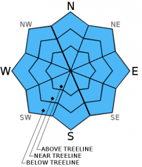
LOW avalanche danger exists on on all aspects and elevations. LOW danger means that avalanches are unlikely, not impossible. Some unstable snow may still exist on isolated terrain features especially in complex or extreme terrain where the recent N-NE winds did not scour away previous wind slabs. Continue to use caution when travelling in the backcountry.

It early season and numerous exposed or barely covered season-ending obstacles exist. While the avalanche danger has decreased, these hazards remain.

1. Low

?

Above Treeline
Generally safe avalanche conditions. Watch for unstable snow on isolated terrain features.

1. Low

?

Near Treeline
Generally safe avalanche conditions. Watch for unstable snow on isolated terrain features.

1. Low

?

Below Treeline
Generally safe avalanche conditions. Watch for unstable snow on isolated terrain features.
    Generally safe avalanche conditions. Watch for unstable snow on isolated terrain features.
Avalanche Problem 1: Normal Caution
  • Type ?
  • Aspect/Elevation ?
  • Likelihood ?
    Certain
    Very Likely
    Likely
    Possible
    Unlikely
  • Size ?
    Historic
    Very Large
    Large
    Small

While most data indicates that avalanche activity has become unlikely and that the snowpack continues to settle and consolidate, some isolated areas of unstable snow may still exist. A few small isolated wind slabs may still linger in complex or extreme terrain where the recent N-NE winds did reach or in areas where the snowpack sits on an unsupported slope. These areas could include those tempting filled-in looking couliors or hanging snowfields with cliffs below them. Keep in mind that after the recent winds, if a near treeline or above treeline area looks nicely filled in, wind slabs likely exist in that area.

The weak sugary layers of snow (facets) below the surface on northerly aspects represent the other lingering issue. Like those small isolated wind slabs, avalanche activity involving these layers has become unlikely but not impossible. Still these layers bear watching as they could reactivate later on. Getting a good handle on where these layers exist now will make for more informed decision making when more snow arrives in the mountains. 

It is still early season and numerous exposed or barely covered rocks, stumps, and other season-ending obstacles exist out there. Even though the avalanche danger has decreased, these hazards remain. 

recent observations

Yesterday observations from Chickadee Ridge in the Mt. Rose backcountry and Red Lake Peak near Carson Pass showed continued settlement and consolidation in the snowpack. On Red Lake Peak previous N-NE winds had scoured many of the traditionally wind loaded N-NE-E aspects near ridgelines and redeposited that snow onto more southwesterly aspects. The wind slabs formed by this wind loading remained small and shallow and did not extend very far down slope. Data collected from northerly aspects on Red Lake Peak and on Chickadee Ridge continues to reveal layers of weaker more sugary snow (facets) in the bottom half of the snowpack. 

Weather and CURRENT CONDITIONS
weather summary

Temperatures started a warming trend yesterday that should last through this week. Many of the upper elevation weather stations reported overnight lows above freezing while most of the lower elevation stations reporting colder overnight lows with some temperatures in the 20's. As the day warms up, this temperature inversion should lift. The forecast calls for daytime highs in the mid to upper 40's above 7000 ft. today and tomorrow. A weak high pressure ridge building over the region should keep the weather warm and dry for the next several days. The northerly winds should start to shift towards the west and decrease in strength as this ridge establishes itself over the next 36 hours. Some high clouds may accompany this ridge, but they should not bring any additional precipitation to the area. 

CONDITIONS ALONG THE SIERRA CREST BETWEEN 8200 FT. AND 9200 FT. IN THE LAST 24 HOURS
6am temperature: 30 to 38 deg. F.
Max. temperature: 37 to 45 deg. F.
Average ridgetop wind direction: North to Southwest
Average ridgetop wind speed: 15 to 25 mph
Maximum ridgetop wind gust: 41 mph
New snowfall: 0 inches
Total snow depth: 10 to 21 inches
Two-Day Mountain Weather Forecast Produced in partnership with the Reno NWS
For 7000 ft. to 8000 ft.
Wednesday Wednesday Night Thursday
Weather: Sunny Clear then becoming partly cloudy Partly cloudy
Temperatures: 42 to 49 deg. F. 27 to 33 deg. F. 43 to 50 deg. F.
Mid Slope Winds: Northwest Southeast becoming variable West
Wind Speed: 10 to 15 mph with gusts to 25 mph 10 to 15 mph becoming light overnight 10 to 15 mph
Expected snowfall: 0 0 0
For 8000 ft. to 9000 ft.
Wednesday Wednesday Night Thursday
Weather: Sunny Clear then becoming partly cloudy Partly cloudy
Temperatures: 39 to 46 deg. F. 23 to 30 deg. F. 40 to 47 deg. F.
Ridge Top Winds: Northwest North shifting to the west after midnight West
Wind Speed: 20 to 30 mph with gusts to 50 mph 25 to 30 mph with gusts to 45 mph decreasing to 15 to 20 mph with gusts to 30 mph after midnight 15 to 25 mph with gusts to 35 mph
Expected snowfall: 0 0 0
Disclaimer

This avalanche advisory is provided through a partnership between the Tahoe National Forest and the Sierra Avalanche Center. This advisory covers the Central Sierra Nevada Mountains between Yuba Pass on the north and Ebbetts Pass on the south. Click here for a map of the forecast area. This advisory applies only to backcountry areas outside established ski area boundaries. This advisory describes general avalanche conditions and local variations always occur. This advisory expires 24 hours after the posted time unless otherwise noted. The information in this advisory is provided by the USDA Forest Service who is solely responsible for its content.