THIS AVALANCHE FORECAST EXPIRED ON April 14, 2016 @ 7:03 am
Avalanche Forecast published on April 13, 2016 @ 7:03 am
Issued by Andy Anderson - Tahoe National Forest - Sierra Avalanche Center

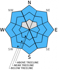
LOW avalanche danger exists this morning. Some slopes steeper than 35 degrees on the E-SE-S-SW-W aspects may see enough sunshine and warming for the avalanche danger to increase to MODERATE due to the possibility of loose wet avalanches. Loose wet activity may also become possible on some NW-N-NE aspects in near and below treeline terrain if the sun hits those slopes. If more cloud cover persists today, loose wet snow will remain more isolated since less melting will occur.


2. Moderate

?

Above Treeline
Heightened avalanche conditions on specific terrain features. Evaluate snow and terrain carefully; identify features of concern.

2. Moderate

?

Near Treeline
Heightened avalanche conditions on specific terrain features. Evaluate snow and terrain carefully; identify features of concern.

2. Moderate

?

Below Treeline
Heightened avalanche conditions on specific terrain features. Evaluate snow and terrain carefully; identify features of concern.
    Heightened avalanche conditions on specific terrain features. Evaluate snow and terrain carefully; identify features of concern.
Avalanche Problem 1: Loose Wet
  • Type ?
  • Aspect/Elevation ?
  • Likelihood ?
    Certain
    Very Likely
    Likely
    Possible
    Unlikely
  • Size ?
    Historic
    Very Large
    Large
    Small

Periods of clearer skies during the night and colder overnight low temperatures should have allowed more snow to refreeze last night than in previous nights. Increased winds, slightly cooler daytime highs, and some scattered cloud cover during the day today should slow down the melting of this overnight refreeze. Still, some areas may see enough sunshine and warmth to melt through last night's refreeze. If this happens the loose wet snow formed by this melting and the loose wet snow lurking below last night's melt-freeze crust will combine to form areas of deep wet loose unsupportable snow on the thawed slopes. Loose wet avalanches could become possible again today. Slopes steeper than 35 degrees on sun-exposed E-SE-S-SW-W aspects in near and below treeline terrain will hold the best potential for loose wet avalanches since they should experience the most warming, but some of the NW-N-NE aspects could also see enough sun for wet snow instabilities to form. Loose wet snow could also form on some isolated above treeline slopes that receive significant sunshine as well. Most of the loose wet snow issues should remain small, but some could still entrain enough snow to cause problems for backcountry travelers especially in areas where they occur near terrain traps like gullies, creeks, and cliffs. If more cloud cover persists over the region, loose wet snow will remain more isolated since less melting will occur.

Once last night's melt-freeze crust starts to become unsupportable and the wet snow starts to deepen, it becomes unstable very quickly. Some signs that enough loose wet snow has formed for larger wet snow instabilities to occur include sinking into wet snow up to your boot tops and small surface instabilities like roller balls, pinwheels, or point releases. It is best to move to more frozen aspects, onto lower angle slopes away from anything steep, or to switch to an activity that does not involve snow before these clues become widespread and before the snowpack starts becoming unsupportable.

recent observations

Yesterday observations on Tamarack Peak showed a mix of supportable and breakable crusts and sticky wet snow on all aspects up to 9800 ft. By mid morning the E aspects had started to soften and by noon they could barely support a skier's weight. The northerly aspects still held mostly supportable crusts at that time. Ski cuts on steep east facing test slopes started to trigger small roller balls and pinwheels around this time as well. Below the surface crusts 10 to 15 inches of wet snow sandwiched between thin crusts existed. 

Weather and CURRENT CONDITIONS
weather summary

Today should bring slightly cooler temperatures and increased southwest winds ahead of a cold front approaching the area. Skies should remain partly cloudy with periods of sunshine until this evening when more clouds move into the region with the cold front. This cold front also brings a chance of meager snowfall for tonight and tomorrow. The areas along the Sierra Crest north of I80 have the best chances for some accumulation and could see up to 5 inches by tomorrow afternoon. South of I80 and east of Lake Tahoe the chances for snow accumulation diminish. Expect much colder temperatures tonight and tomorrow with overnight lows in the 20's and daytime highs in the 30's tomorrow above 7000 ft. The southwest winds should peak tonight and start to taper off tomorrow afternoon as the system starts to move out of the area. 

CONDITIONS ALONG THE SIERRA CREST BETWEEN 8200 FT. AND 9200 FT. IN THE LAST 24 HOURS
6am temperature: 30 to 35 deg. F.
Max. temperature: 41 to 49 deg. F.
Average ridgetop wind direction: Southwest
Average ridgetop wind speed: 15 to 30 mph
Maximum ridgetop wind gust: 71 mph
New snowfall: 0 inches
Total snow depth: 62 to 104 inches
Two-Day Mountain Weather Forecast Produced in partnership with the Reno NWS
For 7000 ft. to 8000 ft.
Wednesday Wednesday Night Thursday
Weather: Partly cloudy with periods of sun Partly cloudy with a 20% chance of snow showers Mostly cloudy with snow likely in the morning and a chance of snow showers in the afternoon
Temperatures: 39 to 46 deg. F. 21 to 28 deg. F. 33 to 39 deg. F.
Mid Slope Winds: Southwest Southwest Southwest
Wind Speed: 15 to 25 mph with gusts to 30 mph increasing to gusts to 40 mph in the afternoon 25 to 35 mph with gusts to 55 mph 25 to 35 mph with gusts to 55 mph decreasing to 45 mph in the afternoon
Expected snowfall: 0 up to 2 up to 3
For 8000 ft. to 9000 ft.
Wednesday Wednesday Night Thursday
Weather: Partly cloudy with periods of sun Partly cloudy with a 20% chance of snow showers Mostly cloudy with snow likely in the morning and a chance of snow showers in the afternoon
Temperatures: 39 to 45 deg. F. 18 to 25 deg. F. 29 to 35 deg. F.
Ridge Top Winds: Southwest Southwest Southwest
Wind Speed: 25 to 35 mph with gusts to 45 mph increasing to 55 mph in the afternoon 45 to 50 mph with gusts to 75 mph increasing to 55 to 60 mph with gusts to 85 mph after midnight 55 to 60 mph with gusts to 85 mph decreasing to 35 to 40 mph with gusts to 60 mph in the afternoon
Expected snowfall: 0 up to 2 up to 3
Disclaimer

This avalanche advisory is provided through a partnership between the Tahoe National Forest and the Sierra Avalanche Center. This advisory covers the Central Sierra Nevada Mountains between Yuba Pass on the north and Ebbetts Pass on the south. Click here for a map of the forecast area. This advisory applies only to backcountry areas outside established ski area boundaries. This advisory describes general avalanche conditions and local variations always occur. This advisory expires 24 hours after the posted time unless otherwise noted. The information in this advisory is provided by the USDA Forest Service who is solely responsible for its content.

For a recorded version of the Avalanche Advisory call (530) 587-3558 x258