THIS AVALANCHE FORECAST EXPIRED ON April 18, 2016 @ 6:28 am
Avalanche Forecast published on April 17, 2016 @ 6:28 am
Issued by Brandon Schwartz - Tahoe National Forest

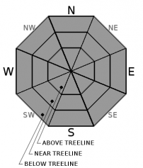
Early this morning, avalanche danger is LOW for all elevations and aspects. Areas of MODERATE avalanche danger will form on slopes 35 degrees and steeper on all aspects at all elevations as loose wet avalanche problems develop in response to rapid daytime warming.

2. Moderate

?

Above Treeline
Heightened avalanche conditions on specific terrain features. Evaluate snow and terrain carefully; identify features of concern.

2. Moderate

?

Near Treeline
Heightened avalanche conditions on specific terrain features. Evaluate snow and terrain carefully; identify features of concern.

2. Moderate

?

Below Treeline
Heightened avalanche conditions on specific terrain features. Evaluate snow and terrain carefully; identify features of concern.
    Heightened avalanche conditions on specific terrain features. Evaluate snow and terrain carefully; identify features of concern.
Avalanche Problem 1: Loose Wet
  • Type ?
  • Aspect/Elevation ?
  • Likelihood ?
    Certain
    Very Likely
    Likely
    Possible
    Unlikely
  • Size ?
    Historic
    Very Large
    Large
    Small

With clear skies last night, a decent snow surface refreeze is expected to have occurred due to radiational cooling despite above freezing air temperatures above 6,500'-7,000'. This superficial snow surface refreeze is expected to allow for a widow of supportable travel conditions early this morning. Rapid warming will melt this crust and create surface wet snow on all aspects as the day progresses. As supportability of the snow surface crust diminishes, loose wet avalanches will become an increasing possibility as deeper wet snow below the crust is exposed.

Avoid late starts today and evaluate carefully any desire to travel in avalanche terrain during the mid day and afternoon hours. Step off of equipment from time to time to gage the depth of body weight boot penetration into wet snow. Once boot penetration depth reaches 8 to 10 inches or more, conditions are becoming problematic. Once signs of deep wet snow are present, exit avalanche terrain by moving to slopes less than 30 degrees is slope angle without steeper terrain above.

recent observations

Observations made yesterday on Rubicon Peak (West Shore Tahoe area) revealed that on E aspects below 8,800' and on N aspects below 8,000', recent storm snow had fully assimilated with the older melt-freeze surface. Above these elevations, up to 1.5 inches of remnant storm snow was observed during the morning hours. This snow likely became wet during the afternoon hours. On E aspects at 8,500', signs of a good snow surface refreeze existed with a surface melt-freeze crust of 6 to 8 inches thick. Looking west into Desolation Wilderness, signs of recent loose wet avalanche activity were present in sun exposed areas.

Weather and CURRENT CONDITIONS
weather summary

High pressure continues to build over the region. Ridgetop winds are decreasing this morning and are forecast to become light today and tomorrow. Air temperature inversion conditions this morning have the coldest air on the mountain valley floors and air temperatures between 7,000' and 9,000' in the mid 30s to low 40s. Maximum daytime air temperatures will climb above average today with upper 40s to upper 50s expected for areas above 7,000'. Sunny skies and clear nights are expected for the next couple of days.

CONDITIONS ALONG THE SIERRA CREST BETWEEN 8200 FT. AND 9200 FT. IN THE LAST 24 HOURS
6am temperature: 33 to 39 deg. F.
Max. temperature: 40 to 49 deg. F.
Average ridgetop wind direction: NE
Average ridgetop wind speed: 31 mph
Maximum ridgetop wind gust: 55 mph
New snowfall: 0 inches
Total snow depth: 57 to 105 inches
Two-Day Mountain Weather Forecast Produced in partnership with the Reno NWS
For 7000 ft. to 8000 ft.
Sunday Sunday Night Monday
Weather: Sunny skies. Clear skies. Sunny skies.
Temperatures: 52 to 59 deg. F. 30 to 37 deg. F. 54 to 61 deg. F.
Mid Slope Winds: E Variable Variable
Wind Speed: 10 to 15 mph. Light winds Light winds
Expected snowfall: 0 0 0
For 8000 ft. to 9000 ft.
Sunday Sunday Night Monday
Weather: Sunny skies. Clear skies. Sunny skies.
Temperatures: 47 to 54 deg. F. 29 to 36 deg. F. 48 to 55 deg. F.
Ridge Top Winds: E Variable Variable
Wind Speed: 10 to 15 mph. Light winds Light winds
Expected snowfall: 0 0 0
Disclaimer

This avalanche advisory is provided through a partnership between the Tahoe National Forest and the Sierra Avalanche Center. This advisory covers the Central Sierra Nevada Mountains between Yuba Pass on the north and Ebbetts Pass on the south. Click here for a map of the forecast area. This advisory applies only to backcountry areas outside established ski area boundaries. This advisory describes general avalanche conditions and local variations always occur. This advisory expires 24 hours after the posted time unless otherwise noted. The information in this advisory is provided by the USDA Forest Service who is solely responsible for its content.

For a recorded version of the Avalanche Advisory call (530) 587-3558 x258