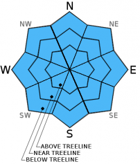
THIS AVALANCHE FORECAST EXPIRED ON April 6, 2016 @ 6:42 am
Avalanche Forecast published on April 5, 2016 @ 6:42 am
Issued by Brandon Schwartz - Tahoe National Forest

Early this morning LOW avalanche danger exists for all elevations and aspects. Starting during the mid to late morning hours and progressing through the rest of the day, MODERATE avalanche danger will form on all aspects and elevations on slopes 35 degrees and steeper due to potential wet snow avalanches. It is best to avoid travel in avalanche terrain during the afternoon hours.

2. Moderate

?

Above Treeline
Heightened avalanche conditions on specific terrain features. Evaluate snow and terrain carefully; identify features of concern.

2. Moderate

?

Near Treeline
Heightened avalanche conditions on specific terrain features. Evaluate snow and terrain carefully; identify features of concern.

2. Moderate

?

Below Treeline
Heightened avalanche conditions on specific terrain features. Evaluate snow and terrain carefully; identify features of concern.
    Heightened avalanche conditions on specific terrain features. Evaluate snow and terrain carefully; identify features of concern.
Avalanche Problem 1: Loose Wet
  • Type ?
  • Aspect/Elevation ?
  • Likelihood ?
    Certain
    Very Likely
    Likely
    Possible
    Unlikely
  • Size ?
    Historic
    Very Large
    Large
    Small

A decent to strong snow surface refreeze is expected to have occurred last night. Air temperatures were at or a few degrees above freezing overnight rather than in the upper 30s and 40s. Clear skies will have allowed for significant radiational cooling. Conditions for snow surface refreeze were much better last night than the previous two nights. As daytime warming progresses, snow surface melt will occur on all aspects. The high sun angle of April will rapidly melt E-SE-S-SW-W aspects this morning and cause a slower rate of melt to occur on upper elevation NW-N-NE aspects.

A window of supportable snow surface conditions with a couple of inches of wet snow on the surface will exist this morning. Once the melt-freeze crust that formed last night melts away, deeper and weaker wet snow that did not refreeze last night will be exposed. Once the snowpack looses supportability to a person on foot, it is time to exit avalanche terrain. Waiting until skis, boards, and sleds penetrate deeply into wet snow is well into the window of snowpack instability for loose wet avalanches.

recent observations

Observations made yesterday on Tamarack Peak (Mount Rose area) and on Red Lake Peak (Carson Pass area) confirmed that a poor snow surface refreeze had occurred Sunday night. In both locations, the poor snow surface refreeze was readily apparent at the trailhead during the mid morning hours. On Tamarack Peak, the crust that did form was only about 1.5 inches thick and did not support the weight of a person on foot in many open areas at 9:30 am. It was also confirmed that an isolated wet slab avalanche had occurred on the Diamond slope of the Fireplug feature near Tamarack Peak on Sunday at 12:30 pm. For more details on the wet slab avalanche see below.

Weather and CURRENT CONDITIONS
weather summary

High pressure will build over the region today and tomorrow for sunny skies and continued above average air temperatures. Generally light to moderate speed E winds are expected. Maximum daytime air temperatures today will be a few degrees cooler than yesterday with the switch from SW to E flow aloft. As the high pressure axis shifts over the Sierra, an 8 to 10 degree increase in maximum daytime air temperatures is forecast for tomorrow over today.

CONDITIONS ALONG THE SIERRA CREST BETWEEN 8200 FT. AND 9200 FT. IN THE LAST 24 HOURS
6am temperature: 31 to 36 deg. F.
Max. temperature: 47 to 53 deg. F.
Average ridgetop wind direction: SW shifting to E
Average ridgetop wind speed: SW 20 mph | E 10 mph
Maximum ridgetop wind gust: SW 38 mph | E 17 mph
New snowfall: 0 inches
Total snow depth: 69 to 112 inches
Two-Day Mountain Weather Forecast Produced in partnership with the Reno NWS
For 7000 ft. to 8000 ft.
Tuesday Tuesday Night Wednesday
Weather: Sunny skies. Clear skies. Sunny skies.
Temperatures: 48 to 55 deg. F. 26 to 33 deg. F. 58 to 64 deg. F.
Mid Slope Winds: E E Variable
Wind Speed: 10 to 15 mph 10 to 15 mph Light winds
Expected snowfall: 0 0 0
For 8000 ft. to 9000 ft.
Tuesday Tuesday Night Wednesday
Weather: Sunny skies. Clear skies. Sunny skies.
Temperatures: 45 to 52 deg. F. 28 to 35 deg. F. 54 to 60 deg. F.
Ridge Top Winds: E E E
Wind Speed: 10 to 20 mph 10 to 20 mph 10 to 15 mph in the morning, becoming light.
Expected snowfall: 0 0 0
Disclaimer

This avalanche advisory is provided through a partnership between the Tahoe National Forest and the Sierra Avalanche Center. This advisory covers the Central Sierra Nevada Mountains between Yuba Pass on the north and Ebbetts Pass on the south. Click here for a map of the forecast area. This advisory applies only to backcountry areas outside established ski area boundaries. This advisory describes general avalanche conditions and local variations always occur. This advisory expires 24 hours after the posted time unless otherwise noted. The information in this advisory is provided by the USDA Forest Service who is solely responsible for its content.

For a recorded version of the Avalanche Advisory call (530) 587-3558 x258