


For 7000 ft. to 8000 ft.
| Sunday | Sunday Night | Monday | |
|---|---|---|---|
| Weather: | Partly cloudy becoming mostly cloudy | Mostly cloudy | Mostly cloudy |
| Temperatures: | 36 to 42 deg. F. | 22 to 27 deg. F. | 37 to 42 deg. F. |
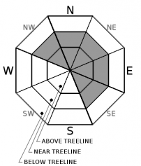
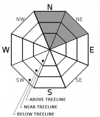
| Mid Slope Winds: | Southwest | Southwest | Southwest |
| Wind Speed: | 15 to 20 mph with gusts to 45 mph | 15 to 20 mph with gusts to 40 mph | 15 to 25 mph with gusts to 45 mph |
| Expected snowfall: | 0 | 0 | 0 |
For 8000 ft. to 9000 ft.
| Sunday | Sunday Night | Monday | |
|---|---|---|---|
| Weather: | Partly cloudy becoming mostly cloudy | Mostly cloudy | Mostly cloudy |
| Temperatures: | 33 to 39 deg. F. | 22 to 27 deg. F. | 34 to 40 deg. F. |
| Ridge Top Winds: | Southwest | Southwest | Southwest |
| Wind Speed: | 25 to 40 mph with gusts to 80 mph | 30 to 45 mph with gusts to 80 mph | 25 to 35 mph with gusts to 75 mph |
| Expected snowfall: | 0 | 0 | 0 |


