


For 7000 ft. to 8000 ft.
| Monday | Monday Night | Tuesday | |
|---|---|---|---|
| Weather: | Mostly cloudy | Mostly cloudy with a slight chance of snow after midnight. | Cloudy with snow likely in the morning and a mix of snow and rain in the afternoon. Snow levels rising to between 7000 and 7500 ft. in the afternoon. |
| Temperatures: | 39 to 44 deg. F. | 23 to 28 deg. F. | 32 to 38 deg. F. |
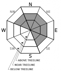
| Mid Slope Winds: | Southwest | Southwest | Southwest |
| Wind Speed: | 10 to 15 mph with gusts to 35 mph | 10 to 15 mph with gusts to 35 mph | 10 to 15 mph with gusts to 35 mph increasing to gusts to 45 mph in the afternoon |
| Expected snowfall: | 0 | 0 | 1 to 3 |
For 8000 ft. to 9000 ft.
| Monday | Monday Night | Tuesday | |
|---|---|---|---|
| Weather: | Mostly cloudy | Mostly cloudy with a slight chance of snow after midnight. | Cloudy with snow likely in the morning. Snow should become more widespread in the afternoon. |
| Temperatures: | 34 to 40 deg. F. | 22 to 28 deg. F. | 30 to 35 deg. F. |
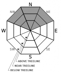
| Ridge Top Winds: | West to southwest | Southwest | Southwest |
| Wind Speed: | 20 to 30 mph with gusts to 55 mph | 15 to 25 mph with gusts to 50 mph | 20 to 35 mph with gusts to 65 mph increasing to 85 mph in the afternoon |
| Expected snowfall: | 0 | up to 1 | 2 to 3 |


