THIS AVALANCHE FORECAST EXPIRED ON December 21, 2016 @ 6:50 am
Avalanche Forecast published on December 20, 2016 @ 6:50 am
Issued by Brandon Schwartz - Tahoe National Forest

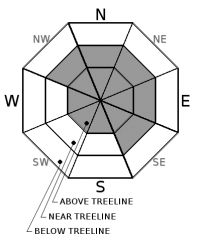
Areas of MODERATE avalanche danger linger near and above treeline due to old wind slabs. Below treeline, LOW avalanche danger exists. Avalanche activity has been reported in isolated areas each of the past two days.

2. Moderate

?

Above Treeline
Heightened avalanche conditions on specific terrain features. Evaluate snow and terrain carefully; identify features of concern.

2. Moderate

?

Near Treeline
Heightened avalanche conditions on specific terrain features. Evaluate snow and terrain carefully; identify features of concern.

1. Low

?

Below Treeline
Generally safe avalanche conditions. Watch for unstable snow on isolated terrain features.
    Heightened avalanche conditions on specific terrain features. Evaluate snow and terrain carefully; identify features of concern.
Avalanche Problem 1: Wind Slab
  • Type ?
  • Aspect/Elevation ?
  • Likelihood ?
    Certain
    Very Likely
    Likely
    Possible
    Unlikely
  • Size ?
    Historic
    Very Large
    Large
    Small

Old wind slabs may remain unstable in isolated areas on all aspects above treeline and on NW-N-NE-E-SE aspects near treeline. Evidence of instability gathered through informal observations and snowpit data has been limited at best, yet isolated avalanche activity continues to occur. The failure layer has not been confirmed in any of the avalanches that occurred over the past two days. Weak faceted snow that formed in the upper snowpack since Dec 15 has been noted in some areas and may be playing a role in the ongoing instability.

Take home point: Avalanches continue to occur in isolated areas. Don't expect signs of instability to present readily, but rather remain elusive. Any additional avalanches that occur will likely take backcountry travelers by surprise. For this reason, don't allow travel partners to get sloppy by grouping up in runout zones, too close to the slopes above or by relying on marginal islands of safety for protection.

recent observations

An avalanche was reported the have occurred yesterday during the late morning hours on Mount Houghton (Mount Rose area) in a SE aspect gully known for cross loading by both SW and NE winds. This avalanche overran previous tracks, much like the avalanche reported on Sunday.

Observations made and received yesterday from Castle Peak (Donner Summit area), Steven's Peak (Carson Pass area), and on Relay and Tamarack Peaks (Mount Rose area), showed that signs of instability were very limited. Occasionally but not always, snowpit tests have pointed to some potential instability in the upper portion of the snowpack. Data is limited, but newly formed facets have been observed on top of the Dec 15 rain crust in some but not all areas. In the highest elevation areas (above ~9,700') where the Dec 15 rain crust is absent, newly formed facets have been observed within the lower portion of the recent storm snow.

Weather and CURRENT CONDITIONS
weather summary

A strong air temperature inversion remains in place over the region. Air temperatures this morning are above freezing at the mid and upper elevations and in the 20s on the mountain valley floors. Ridgetop winds are expected to increase to moderate speed this afternoon out of the SW as a very weak weather system passes over the northern half of the forecast area. Some light snow showers are expected tonight with little to no accumulation. Following the passage of the weak weather system, ridgetop winds are forecast to shift to the E for Wednesday. Maximum daytime air temperatures above 7,000' are expected in the 40s today, and in the 30s on Wednesday.


CONDITIONS ALONG THE SIERRA CREST BETWEEN 8200 FT. AND 9200 FT. IN THE LAST 24 HOURS
6am temperature: 36 to 42 deg. F.
Max. temperature: 36 to 48 deg. F.
Average ridgetop wind direction: Variable SW and NE
Average ridgetop wind speed: 10 mph
Maximum ridgetop wind gust: 25 mph
New snowfall: 0 inches
Total snow depth: Along the Sierra Crest: 20 to 33 inches | In the Mt. Rose area: 53 inches
Two-Day Mountain Weather Forecast Produced in partnership with the Reno NWS
For 7000 ft. to 8000 ft.
Tuesday Tuesday Night Wednesday
Weather: Partly cloudy skies. Mostly cloudy skies. A slight chance of snow in the evening. A chance of snow after midnight. Partly cloudy skies, becoming sunny.
Temperatures: 43 to 49 deg. F. 22 to 27 deg. F. 36 to 41 deg. F.
Mid Slope Winds: SW SW E
Wind Speed: Light winds Light winds 10 to 15 mph with gusts to 30 mph in the morning, becoming light.
Expected snowfall: 0 0 to trace 0
For 8000 ft. to 9000 ft.
Tuesday Tuesday Night Wednesday
Weather: Partly cloudy skies. Mostly cloudy skies. A slight chance of snow in the evening. A chance of snow after midnight. Partly cloudy skies, becoming sunny.
Temperatures: 41 to 47 deg. F. 23 to 28 deg. F. 35 to 40 deg. F.
Ridge Top Winds: SW NE E
Wind Speed: Light winds, becoming 10 to 15 mph with gusts to 35 mph in the afternoon. Light winds becoming 10 to 15 mph with gusts to 35 mph after midnight. 10 to 15 mph. Gusts up to 40 mph decreasing to 30 mph in the afternoon.
Expected snowfall: 0 0 to trace 0
Disclaimer

This avalanche advisory is provided through a partnership between the Tahoe National Forest and the Sierra Avalanche Center. This advisory covers the Central Sierra Nevada Mountains between Yuba Pass on the north and Ebbetts Pass on the south. Click here for a map of the forecast area. This advisory applies only to backcountry areas outside established ski area boundaries. This advisory describes general avalanche conditions and local variations always occur. This advisory expires 24 hours after the posted time unless otherwise noted. The information in this advisory is provided by the USDA Forest Service who is solely responsible for its content.

For a recorded version of the Avalanche Advisory call (530) 587-3558 x258