THIS AVALANCHE FORECAST EXPIRED ON December 23, 2016 @ 6:50 am
Avalanche Forecast published on December 22, 2016 @ 6:50 am
Issued by Steve Reynaud - Tahoe National Forest

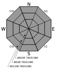
Low avalanche danger continues across the forecast area for today at all elevations.  Normal caution is advised.  Avalanche danger is expected to increase tomorrow as a significant winter storm moves into our area. An avalanche watch has been issued to reflect this expected increase in avalanche danger.

1. Low

?

Above Treeline
Generally safe avalanche conditions. Watch for unstable snow on isolated terrain features.

1. Low

?

Near Treeline
Generally safe avalanche conditions. Watch for unstable snow on isolated terrain features.

1. Low

?

Below Treeline
Generally safe avalanche conditions. Watch for unstable snow on isolated terrain features.
    Generally safe avalanche conditions. Watch for unstable snow on isolated terrain features.
Avalanche Problem 1: Normal Caution
  • Type ?
  • Aspect/Elevation ?

Normal caution is advised throughout the forecast region.  Continue to keep a lookout for areas where strong dense snow is over less dense and weaker snow.  These areas may be found in complex terrain or in cross loaded gully features.  Minimize risk by traveling one at a time through avalanche terrain.  Regroup in safe areas away from runout zones, practice effective communication within your group, and have a travel plan.  Firm rain crusts are present in wind scoured areas that may pose travel difficulties and potential fall hazards.

recent observations

Observations were made and received yesterday from Castle Peak (Donner Summit area) and Incline Lake Peak (Mt. Rose area).  Both areas had a variety of snow surface crusts with soft snow in wind protected areas.  On Castle Peak in the 8500' to 8900' range, near surface facets and near crust facets were present in all areas where recent storm snow sat on top of the 12/15 rain crust.  This facet combination did not present a current problem but did show some indication that future snow loading could become an issue.  This observation matches well with other recent observations showing faceting is most prevalent in wind protected, shaded areas from 8000 to 9500' throughout the forecast area.  Firm rain crusts were encountered in wind scoured and exposed locations.   

Weather and CURRENT CONDITIONS
weather summary

Mostly quiet weather conditions throughout today with cloudy skies and increasing W winds into the afternoon.  A significant winter storm will impact our region Friday morning through midday Saturday bringing heavy mountain snow.  1 to 2 feet of snow is expected above 7000' with 8 to 16 inches at lake level.  Sierra ridge gusts are forecasted to be over 100mph creating white out conditions by Friday afternoon.

CONDITIONS ALONG THE SIERRA CREST BETWEEN 8200 FT. AND 9200 FT. IN THE LAST 24 HOURS
6am temperature: 23 to 28 deg. F.
Max. temperature: 33 deg. F.
Average ridgetop wind direction: NE shifting to W
Average ridgetop wind speed: 15 to 20 mph
Maximum ridgetop wind gust: 37 mph
New snowfall: Trace to 2 inches
Total snow depth: In the Sierra 20 to 31 inches | In the Mt. Rose area 54 inches
Two-Day Mountain Weather Forecast Produced in partnership with the Reno NWS
For 7000 ft. to 8000 ft.
Thursday Thursday Night Friday
Weather: Partly cloudy. Partly cloudy then becoming mostly cloudy. Cloudy. Snow.
Temperatures: 39 to 44 deg. F. 24 to 29 deg. F. 31 to 36 deg. F.
Mid Slope Winds: Light winds. SW SW
Wind Speed: Gusting to 25mph in the afternoon. 10 to 15 mph with gusts up to 35mph. 20 to 30mph with gusts to 65mph.
Expected snowfall: 0 0 6 to 12
For 8000 ft. to 9000 ft.
Thursday Thursday Night Friday
Weather: Partly cloudy. Partly cloudy then becoming mostly cloudy. Cloudy. Snow likely in the morning then snow in the afternoon.
Temperatures: 36 to 41 deg. F. 23 to 28 deg. F. 28 to 34 deg. F.
Ridge Top Winds: W SW SW
Wind Speed: 10 to 15mph. Gusts to 30mph increasing to 40mph in the afternoon. 20 to 30mph. Gusts to 50mph increasing to 70mph after midnight. 30 to 45mph with gusts to 95mph. Increasing to 35 to 55mph with gusts to 100mph in the afternoon.
Expected snowfall: 0 0 8 to 14
Disclaimer

This avalanche advisory is provided through a partnership between the Tahoe National Forest and the Sierra Avalanche Center. This advisory covers the Central Sierra Nevada Mountains between Yuba Pass on the north and Ebbetts Pass on the south. Click here for a map of the forecast area. This advisory applies only to backcountry areas outside established ski area boundaries. This advisory describes general avalanche conditions and local variations always occur. This advisory expires 24 hours after the posted time unless otherwise noted. The information in this advisory is provided by the USDA Forest Service who is solely responsible for its content.

For a recorded version of the Avalanche Advisory call (530) 587-3558 x258