THIS AVALANCHE FORECAST EXPIRED ON December 24, 2016 @ 6:58 am
Avalanche Forecast published on December 23, 2016 @ 6:58 am
Issued by Steve Reynaud - Tahoe National Forest

A fast and powerful winter storm will impact our area starting this morning and continue through tonight.  Avalanche hazard will quickly rise to High as snowfall rates approach 3'' per hour later this morning.  Wind slab and storm slab avalanche problems will be very likely at all elevations throughout the region.  An avalanche warning has been issued for the forecast area until 7am Saturday morning.  Very dangerous avalanche conditions exist.  Travel in avalanche terrain is not recommended.

4. High

?

Above Treeline
Very dangerous avalanche conditions. Travel in avalanche terrain not recommended.

4. High

?

Near Treeline
Very dangerous avalanche conditions. Travel in avalanche terrain not recommended.

4. High

?

Below Treeline
Very dangerous avalanche conditions. Travel in avalanche terrain not recommended.
    Very dangerous avalanche conditions. Travel in avalanche terrain not recommended.
Avalanche Problem 1: Wind Slab
  • Type ?
  • Aspect/Elevation ?
  • Likelihood ?
    Certain
    Very Likely
    Likely
    Possible
    Unlikely
  • Size ?
    Historic
    Very Large
    Large
    Small

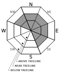
As the storm intensity increases throughout the morning, plenty of new snow will be available for wind transport to form new wind slabs.  Gale force SW winds with wind gusts up to 100mph are forecasted over ridges and peaks through today and tonight.  Wind slabs will quickly form this morning on NW-N-NE-E-SE aspects near treeline and above treeline and continue to build throughout the day.  Natural avalanches are likely and human triggered avalanches are very likely.  

Travel in avalanche terrain is not recommended today.  Avoid avalanche runout zones.  Dangerous avalanche conditions will exist.


Avalanche Problem 2: Storm Slab
  • Type ?
  • Aspect/Elevation ?
  • Likelihood ?
    Certain
    Very Likely
    Likely
    Possible
    Unlikely
  • Size ?
    Historic
    Very Large
    Large
    Small

Snowfall intensity will increase early this morning and reach upwards of 3'' per hour through most of the mid day hours.  This fast moving winter storm could drop 1 to 2 feet of snow above 7000' today and tonight with more at higher elevations.  Storm slabs will become very likely on all aspects below treeline and near treeline as this new storm snow has difficulty bonding to itself and/or the old snow surface.  On shaded W-NW-N-NE-E aspects near treeline and below treeline the possibility exists for these storm slabs to fail on a near crust facet layer that exists on top of the Dec. 15 rain crust.  These avalanches could be larger in size, remotely triggered, entrain more snow, and have much higher consequences.

Travel in avalanche terrain is not recommended.  Natural triggered avalanches are likely and human triggered avalanches are very likely.  Very dangerous avalanche conditions exist.  Avoid avalanche runout zones.


recent observations

Observations were made and received at Ophir Peak (Mt. Rose area), Castle Peak (Donner Summit area), and Forestdale/Frog Lake Ridge (Carson Pass area).  Unconsolidated surface snow was found above a supportable base in most areas.  Near surface facets and near crust facets above the Dec. 15 rain crust existed in all wind protected areas that had not seen wind scouring.  Observations showed concern as to the strength of these near crust facets and how they will react to additional load.  Temperatures were warming with increasing winds throughout the day. 

Weather and CURRENT CONDITIONS
weather summary

A winter storm warning is in effect from 6am this morning to 7am Saturday morning.  Heavy snow is forecasted to start at 9am this morning to 8pm tonight.  Snowfall rates will get up to 3'' per hour this morning and continue through the day before tapering later this evening.  Gale force SW winds are expected with gusts above 8000' near 100mph.  Forecasted snowfall is 1 to 2 feet above 7000' with 8-14'' at Lake level.  This storm track should favor larger snowfall totals south of Hwy. 50.

CONDITIONS ALONG THE SIERRA CREST BETWEEN 8200 FT. AND 9200 FT. IN THE LAST 24 HOURS
6am temperature: 19 to 22 deg. F.
Max. temperature: 41 deg. F.
Average ridgetop wind direction: SW
Average ridgetop wind speed: 35 to 50 mph
Maximum ridgetop wind gust: 88 mph
New snowfall: Trace to 2 inches
Total snow depth: Along the Sierra Crest 20 to 31 inches | In the Mt. Rose area 53 inches
Two-Day Mountain Weather Forecast Produced in partnership with the Reno NWS
For 7000 ft. to 8000 ft.
Friday Friday Night Saturday
Weather: Cloudy. Snow. Cloudy. Snow Cloudy. Snow showers in the morning then chance of snow showers in the afternoon.
Temperatures: 31 to 36 deg. F. 14 to 19 deg. F. 20 to 25 deg. F.
Mid Slope Winds: SW SW SW
Wind Speed: 20 to 30mph. Gusts to 55mph increasing to 70mph in the afternoon. 15 to 25mph. Gusts to 50mph decreasing to 40mph after midnight. 15 to 20mph with gusts to 35mph in the morning becoming light.
Expected snowfall: 8 to 12 5 to 8 1 to 3
For 8000 ft. to 9000 ft.
Friday Friday Night Saturday
Weather: Cloudy. Snow. Cloudy. Snow. Cloudy. Snow showers in the morning then chance of snow showers in the afternoon.
Temperatures: 28 to 34 deg. F. 10 to 16 deg. F. 17 to 23 deg. F.
Ridge Top Winds: SW SW W
Wind Speed: 30 to 45mph increasing to 35 to 55mph in the afternoon. Gusts up to 100mph. 30 to 45mph with gusts to 95mph decreasing to 20 to 30mph with gusts to 65mph after midnight. 15 to 25mph. Gusts to 50mph decreasing to 35mph in the afternoon.
Expected snowfall: 9 to 14 6 to 10 2 to 4
Disclaimer

This avalanche advisory is provided through a partnership between the Tahoe National Forest and the Sierra Avalanche Center. This advisory covers the Central Sierra Nevada Mountains between Yuba Pass on the north and Ebbetts Pass on the south. Click here for a map of the forecast area. This advisory applies only to backcountry areas outside established ski area boundaries. This advisory describes general avalanche conditions and local variations always occur. This advisory expires 24 hours after the posted time unless otherwise noted. The information in this advisory is provided by the USDA Forest Service who is solely responsible for its content.

For a recorded version of the Avalanche Advisory call (530) 587-3558 x258