THIS AVALANCHE FORECAST EXPIRED ON December 26, 2016 @ 6:55 am
Avalanche Forecast published on December 25, 2016 @ 6:55 am
Issued by Andy Anderson - Tahoe National Forest - Sierra Avalanche Center

Human triggered avalanches remain possible at all elevations today due to a combination of storm slabs in near and below treeline terrain, wind slabs in wind-loaded near and above treeline terrain, and loose dry avalanches in non-wind-affected terrain. Remote triggering of the storm slabs and wind slabs may be possible today. MODERATE avalanche danger exists at all elevations. Evaluate the snowpack and terrain carefully and use this data to inform your decision making and route planning.

2. Moderate

?

Above Treeline
Heightened avalanche conditions on specific terrain features. Evaluate snow and terrain carefully; identify features of concern.

2. Moderate

?

Near Treeline
Heightened avalanche conditions on specific terrain features. Evaluate snow and terrain carefully; identify features of concern.

2. Moderate

?

Below Treeline
Heightened avalanche conditions on specific terrain features. Evaluate snow and terrain carefully; identify features of concern.
    Heightened avalanche conditions on specific terrain features. Evaluate snow and terrain carefully; identify features of concern.
Avalanche Problem 1: Storm Slab
  • Type ?
  • Aspect/Elevation ?
  • Likelihood ?
    Certain
    Very Likely
    Likely
    Possible
    Unlikely
  • Size ?
    Historic
    Very Large
    Large
    Small

Human triggered storm slab avalanches will remain possible in open areas below treeline today. These avalanches could have 1 to 2 ft deep crowns and could still be triggered remotely in some areas. They could fail at the base of the new snow where loose, weak, old snow (near surface and near crust facets) exist above the 12/15 rain crust. This problem may become more widespread since the new snow may start to represent more of a slab layer as it starts to consolidate in some areas. This avalanche problem may also become a persistent slab problem in the coming days in areas where the near crust facets remain weak. In some areas, the new snow may not be quite slabby enough or there may not be quite enough new snow for this problem to exist. Storm slabs could exist on any aspects on slopes steeper than 34 degrees, but data indicates that the NW-N-NE-E aspects represent the best places to find these storm slabs sitting on near crust facets

Clues like other avalanches, shooting cracks, collapsing, and an upside down snowpack can all help in figuring out where storm slabs may exist. Avoiding slopes with potential storm slabs by sticking to lower angle slopes or well-anchored slopes can allow for a more fun and safer day recreating on the snow.

Avalanche Problem 2: Wind Slab
  • Type ?
  • Aspect/Elevation ?
  • Likelihood ?
    Certain
    Very Likely
    Likely
    Possible
    Unlikely
  • Size ?
    Historic
    Very Large
    Large
    Small

Wind slabs that formed during the storm may still remain fragile on the exposed near and above treeline wind-loaded N-NE-E aspects and on the cross-loaded NW and SE aspects on slopes steeper than 35 degrees. In addition to these wind slabs, NE winds during the night may have transported some snow onto the W-SW-S aspects and cross-loaded the NW and SE aspects again. These new wind slabs should remain smaller and only form near ridgelines without extending very far down-slope. All of these wind slabs may not bond well to the old snow surfaces below them especially where they form above near surface and near crust facets. Even though wind slabs should have become more difficult to trigger today than they were yesterday, human triggered wind slab avalanches will remain possible today. In many areas, wind slabs could measure 1.5 to 3 ft in depth with even larger wind slabs on the most wind loaded slopes. They could propagate across a slope and could break above the person who triggers them.  

Use clues like cornices, blowing snow, snow drifts, wind pillows, scoured surfaces, ripples in the snow, and other wind created textures to help determine where wind slabs may exist. Use this knowledge to find terrain without wind slabs to recreate on. 

Avalanche Problem 3: Loose Dry
  • Type ?
  • Aspect/Elevation ?
  • Likelihood ?
    Certain
    Very Likely
    Likely
    Possible
    Unlikely
  • Size ?
    Historic
    Very Large
    Large
    Small

In many areas, the new snow will remain cold, dry, and unconsolidated enough that skier-triggered loose dry sluffs will be likely today on slopes steeper than 37 degrees. The northerly aspects where the coldest snow exists represent the most likely place to find loose dry avalanches, but they could occur on any aspect where cold, unconsolidated snow exists. These loose dry avalanches should remain small and only entrain the upper portion of the new snow. They may not involve enough snow to bury a person but could knock a person off balance. In some areas where the new snow has consolidated enough or where the wind has affected the new snow, loose dry avalanches will be less of a problem, but the storm slabs and wind slabs mentioned above may exist in those areas. 

recent observations

Several skier-triggered avalanches involving the storm snow occurred yesterday along the Sierra Crest. Reports of below treeline storm slab avalanches came in from Grouse Rocks (N aspect), Silver Peak (N aspect), and Andesite Ridge (NE and E aspects). One natural avalanche was reported on a NW aspect in the Grouse Rocks area. All of these avalanches broke either within the new snow or at the base of the new snow on a layer of loose old snow (near crust facets) above the 12/15 rain crust. They all broke on slopes steeper than 34 degrees and had crowns that measured between 1 and 2 ft. On Silver Peak and on Grouse rocks, skiers remotely triggered some of these slides from lower angle terrain. One of the avalanches on Andesite Ridge carried a person downslope resulting in some lost gear but no injuries or significant burials. In near and above treeline terrain a small wind slab avalanche triggered by dropping a cornice piece onto the slope was reported on a NE aspect on Mt. Judah. In the Blue Lakes area near Carson Pass 6 to 18 inches of new snow resting on near crust facets on top of the 12/15 rain crust existed. Tests and observations showed poor bonding between the new snow and the loose weak facets below it.  

Weather and CURRENT CONDITIONS
weather summary

After another 1 to 3 inches of snow fell yesterday, the weather started to clear and the winds shifted to the NE overnight due to a high-pressure ridge building over the area. The winds have shifted back to the west and southwest this morning and decreased again. Temperatures plummeted during the night as the skies cleared with lows below zero at many of the lower elevations where cold air remains trapped this morning. At the upper elevations, sensors showed temperatures in the single digits in most places. The forecast calls for the calm, cold, dry, and mostly clear weather to continue through tomorrow. A warming trend should begin tomorrow with daytime highs at the upper elevations climbing a few degrees above today. 

CONDITIONS ALONG THE SIERRA CREST BETWEEN 8200 FT. AND 9200 FT. IN THE LAST 24 HOURS
6am temperature: 0 to 14 deg. F.
Max. temperature: 19 to 27 deg. F.
Average ridgetop wind direction: Southwest to northeast overnight back to southwest
Average ridgetop wind speed: SW @ 10 mph | NE @ 15 to 20 mph
Maximum ridgetop wind gust: 50 mph
New snowfall: 1 to 3 inches
Total snow depth: Along the Sierra Crest: 30 to 46 inches | In the Mt. Rose area: 60 inches
Two-Day Mountain Weather Forecast Produced in partnership with the Reno NWS
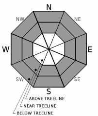
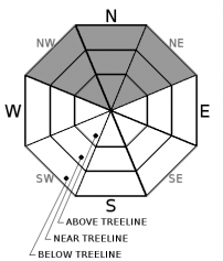
For 7000 ft. to 8000 ft.
Sunday Sunday Night Monday
Weather: Sunny becoming partly cloudy Partly cloudy becoming clear Sunny
Temperatures: 23 to 28 deg. F. 3 to 11 deg. F. 26 to 31 deg. F.
Mid Slope Winds: Variable Variable Variable
Wind Speed: Light Light Light
Expected snowfall: 0 0 0
For 8000 ft. to 9000 ft.
Sunday Sunday Night Monday
Weather: Sunny becoming partly cloudy Partly cloudy becoming clear Sunny
Temperatures: 20 to 26 deg. F. 3 to 8 deg. F. 24 to 29 deg. F.
Ridge Top Winds: West Variable Southwest
Wind Speed: 10 to 15 mph with gusts to 25 mph in the morning becoming light in the afternoon Light 10 to 15 mph with gusts to 25 mph in the morning
Expected snowfall: 0 0 0
Disclaimer

This avalanche advisory is provided through a partnership between the Tahoe National Forest and the Sierra Avalanche Center. This advisory covers the Central Sierra Nevada Mountains between Yuba Pass on the north and Ebbetts Pass on the south. Click here for a map of the forecast area. This advisory applies only to backcountry areas outside established ski area boundaries. This advisory describes general avalanche conditions and local variations always occur. This advisory expires 24 hours after the posted time unless otherwise noted. The information in this advisory is provided by the USDA Forest Service who is solely responsible for its content.

For a recorded version of the Avalanche Advisory call (530) 587-3558 x258