


For 7000 ft. to 8000 ft.
| Tuesday | Tuesday Night | Wednesday | |
|---|---|---|---|
| Weather: | Mostly cloudy skies, becoming partly cloudy. | Partly cloudy skies. | Sunny skies. |
| Temperatures: | 36 to 41 deg. F. | 16 to 22 deg. F. | 40 to 45 deg. F. |
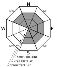
| Mid Slope Winds: | SW | W | Variable |
| Wind Speed: | 10 to 15 mph in the morning, becoming light. | 10 to 15 mph with gusts to 45 mph in the evening, becoming light. | Light winds |
| Expected snowfall: | 0 | 0 | 0 |
For 8000 ft. to 9000 ft.
| Tuesday | Tuesday Night | Wednesday | |
|---|---|---|---|
| Weather: | Mostly cloudy skies, becoming partly cloudy. | Partly cloudy skies. | Sunny skies. |
| Temperatures: | 34 to 39 deg. F. | 17 to 22 deg. F. | 38 to 44 deg. F. |
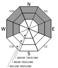
| Ridge Top Winds: | W | W | W |
| Wind Speed: | 20 to 30 mph with gusts to 60 mph. | 20 to 35 mph. Gusts to 75 mph decreasing to 60 mph after midnight. | 15 to 25 mph with gusts to 45 mph in the morning, becoming light. |
| Expected snowfall: | 0 | 0 | 0 |


