THIS AVALANCHE FORECAST EXPIRED ON February 22, 2016 @ 6:46 am
Avalanche Forecast published on February 21, 2016 @ 6:46 am
Issued by Brandon Schwartz - Tahoe National Forest

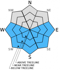
Early this morning, LOW avalanche danger exists for all elevations and aspects. Areas of MODERATE avalanche danger will form in response to daytime warming mainly on E-SE-S-SW-W aspects on slopes 35 degrees and steeper due to the possibility of loose wet avalanches. Isolated loose wet instability may occur in some areas on NW-N-NE aspects as well.

2. Moderate

?

Above Treeline
Heightened avalanche conditions on specific terrain features. Evaluate snow and terrain carefully; identify features of concern.

2. Moderate

?

Near Treeline
Heightened avalanche conditions on specific terrain features. Evaluate snow and terrain carefully; identify features of concern.

2. Moderate

?

Below Treeline
Heightened avalanche conditions on specific terrain features. Evaluate snow and terrain carefully; identify features of concern.
    Heightened avalanche conditions on specific terrain features. Evaluate snow and terrain carefully; identify features of concern.
Avalanche Problem 1: Loose Wet
  • Type ?
  • Aspect/Elevation ?
  • Likelihood ?
    Certain
    Very Likely
    Likely
    Possible
    Unlikely
  • Size ?
    Historic
    Very Large
    Large
    Small

The surface snow will continue to warm over the next few days and begin the slow transition from recent storm snow to well established supportable melt-freeze snow. During this time period, an upper snowpack structure of surface wet snow on top of yet to transition colder recent storm snow will be prone to human triggered loose wet avalanches. Most instability is expected to take on the form of roller balls and pinwheels. In areas where human triggered loose wet avalanches occur, enough snow is available to create avalanches large enough to bury or injure a person. The vast majority of instability is expected to occur on E-SE-S-SW-W aspects. Isolated instability may occur on low to mid elevation NW-N-NE aspects as well.

Avoid the premature search for "corn snow" while the upper snowpack remains in a transitional state. Use quick hand pits to identify surface wet snow on top of colder recent storm snow, yet to undergo melt-freeze. Slopes steeper than 35 degrees where this near surface snowpack structure exists are best avoided once a couple inches or more of surface wet snow are present. Human triggering of roller balls and pinwheels approaching or exceeding 1 foot in diameter are indicators that loose wet avalanche activity is possible.


recent observations

Observations made and received yesterday from Silver Peak (Pole Creek area) and Horse Canyon (Bear Valley area) gave no indications of ongoing instability within either the recent storm snow or recently formed wind slabs. Widespread areas of wind affected surface snow were observed both above and below treeline on all aspects on Silver Peak. Snow surface warming was observed during the mid day hours in sun exposed areas on all aspects below 7,500' to 8,000'.

Weather and CURRENT CONDITIONS
weather summary

High pressure will build over the forecast area during the next several days with sunny skies and clear nights expected. A weather system passing to the north of the forecast area will increase SW ridgetop winds today and tonight. Winds are forecast to shift to the NW to N tomorrow and remain moderate to strong in speed. Maximum daytime air temperatures in the mid 30s to upper 40s today will cool a few degrees for tomorrow. A warming trend is expected as the week continues.

CONDITIONS ALONG THE SIERRA CREST BETWEEN 8200 FT. AND 9200 FT. IN THE LAST 24 HOURS
6am temperature: 25 to 35 deg. F.
Max. temperature: 42 to 45 deg. F.
Average ridgetop wind direction: SSW
Average ridgetop wind speed: 18 mph
Maximum ridgetop wind gust: 32 mph
New snowfall: 0 inches
Total snow depth: 60 to 92 inches
Two-Day Mountain Weather Forecast Produced in partnership with the Reno NWS
For 7000 ft. to 8000 ft.
Sunday Sunday Night Monday
Weather: Sunny skies. Clear skies. Sunny skies.
Temperatures: 42 to 49 deg. F. 28 to 32 deg. F. 40 to 48 deg. F.
Mid Slope Winds: SW SW W shifting to N in the afternoon.
Wind Speed: 10 to 15 mph with gusts to 25 mph. 15 to 25 mph with gusts to 35 mph. 10 to 15 mph. Gusts up to 25 mph.
Expected snowfall: 0 0 0
For 8000 ft. to 9000 ft.
Sunday Sunday Night Monday
Weather: Sunny skies. Clear skies. Sunny skies.
Temperatures: 35 to 42 deg. F. 24 to 28 deg. F. 30 to 40 deg. F.
Ridge Top Winds: SW W NW
Wind Speed: 20 to 35 mph with gusts to 45 mph. 15 to 30 mph with gusts to 45 mph in the evening, increasing to 25 to 40 mph with gusts to 55 mph. 25 to 35 mph. Gusts up to 55 mph, decreasing to 45 mph in the afternoon.
Expected snowfall: 0 0 0
Disclaimer

This avalanche advisory is provided through a partnership between the Tahoe National Forest and the Sierra Avalanche Center. This advisory covers the Central Sierra Nevada Mountains between Yuba Pass on the north and Ebbetts Pass on the south. Click here for a map of the forecast area. This advisory applies only to backcountry areas outside established ski area boundaries. This advisory describes general avalanche conditions and local variations always occur. This advisory expires 24 hours after the posted time unless otherwise noted. The information in this advisory is provided by the USDA Forest Service who is solely responsible for its content.