THIS AVALANCHE FORECAST EXPIRED ON February 6, 2016 @ 6:56 am
Avalanche Forecast published on February 5, 2016 @ 6:56 am
Issued by Andy Anderson - Tahoe National Forest - Sierra Avalanche Center

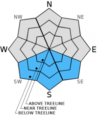
This morning the avalanche danger is LOW on all aspects and elevations. Some pockets of MODERATE avalanche danger may form below 9000 ft. on sun-exposed SE-S-SW aspects steeper than 35 degrees as the day warms up, and some small loose wet snow instabilities become possible. The amount of warming that actually occurs today will dictate how widespread these possible wet snow instabilities may be. 

2. Moderate

?

Above Treeline
Heightened avalanche conditions on specific terrain features. Evaluate snow and terrain carefully; identify features of concern.

2. Moderate

?

Near Treeline
Heightened avalanche conditions on specific terrain features. Evaluate snow and terrain carefully; identify features of concern.

2. Moderate

?

Below Treeline
Heightened avalanche conditions on specific terrain features. Evaluate snow and terrain carefully; identify features of concern.
    Heightened avalanche conditions on specific terrain features. Evaluate snow and terrain carefully; identify features of concern.
Avalanche Problem 1: Loose Wet
  • Type ?
  • Aspect/Elevation ?
  • Likelihood ?
    Certain
    Very Likely
    Likely
    Possible
    Unlikely
  • Size ?
    Historic
    Very Large
    Large
    Small

Any wet snow that formed yesterday should have refrozen last night. This solid refreeze, the fact that the snow has now undergone repeated melting and refreezing, the possibility of some increased afternoon cloud cover, and the low sun angles of Feb. should mean that wet snow instabilities will be smaller and more isolated today. Today's warmer temperatures and mostly clear skies could still cause enough warming for some loose wet snow instabilities to form on the sun-exposed SE-S-SW aspects.  Small pinwheels, roller balls, and point release avalanches (sluffs) should represent the majority of the loose wet instabilities, but a few could entrain enough snow to cause issues for backcountry travelers in isolated areas or extreme terrain. 

recent observations

Observations from Incline Lake Peak and Deep Creek showed a well bonded snowpack with 10 to 14 inches of soft snow sitting above a thick firm rain crust on sheltered northerly aspects in near and below treeline terrain. On more exposed near and above treeline terrain wind scoured surfaces, firm wind slabs, icy crusts, and other wind sculpted features existed on the snow surface. On more sun exposed southerly aspects in the Incline Lake Peak and Rose Knob area some old loose wet point releases existed, and at least one skier triggered loose wet point release occurred between 10 am and 2 pm yesterday on a sun-exposed SE aspect at 8600 ft. in the 3rd Creek drainage. 

Weather and CURRENT CONDITIONS
weather summary

Temperatures at the lower elevations remain much colder than those reported by sensors at the upper elevations this morning. This inversion should lift quickly in the mountains today. The warming trend should continue due to a high pressure ridge settling over the region. Expect daytime highs in the upper 30's to low 40's above 7000 ft. today and in the low to mid 40's tomorrow. Skies should also remain mostly clear except for this afternoon and evening when some clouds could develop across the forecast area due to a low pressure in the Pacific Northwest. Winds should remain moderate to light, and the forecast calls for them to shift between south, west, north and southeast over the next 36 hours. 

CONDITIONS ALONG THE SIERRA CREST BETWEEN 8200 FT. AND 9200 FT. IN THE LAST 24 HOURS
6am temperature: 19 to 27 deg. F.
Max. temperature: 33 to 39 deg. F.
Average ridgetop wind direction: East
Average ridgetop wind speed: 15 to 20 mph
Maximum ridgetop wind gust: 41 mph
New snowfall: 0 inches
Total snow depth: 70 to 91 inches
Two-Day Mountain Weather Forecast Produced in partnership with the Reno NWS
For 7000 ft. to 8000 ft.
Friday Friday Night Saturday
Weather: Mostly sunny with some clouds developing over the region in the afternoon Mostly cloudy to partly cloudy Partly cloudy becoming sunny
Temperatures: 36 to 43 deg. F. 16 to 22 deg. F. 40 to 47 deg. F.
Mid Slope Winds: South West North shifting to the southeast in the afternoon
Wind Speed: Light in the morning becoming 10 to 15 mph in the afternoon 15 to 20 mph 10 to 15 mph with gusts to 25 mph
Expected snowfall: 0 0 0
For 8000 ft. to 9000 ft.
Friday Friday Night Saturday
Weather: Mostly sunny with some clouds developing over the region in the afternoon Mostly cloudy to partly cloudy Partly cloudy becoming sunny
Temperatures: 34 to 41 deg. F. 14 to 21 deg. F. 37 to 44 deg. F.
Ridge Top Winds: East shifting to the south West North shifting to the southeast in the afternoon
Wind Speed: 15 to 20 mph with gusts to 30 mph 15 to 25 mph with gusts to 35 mph 20 to 25 mph with gusts to 35 mph
Expected snowfall: 0 0 0
Disclaimer

This avalanche advisory is provided through a partnership between the Tahoe National Forest and the Sierra Avalanche Center. This advisory covers the Central Sierra Nevada Mountains between Yuba Pass on the north and Ebbetts Pass on the south. Click here for a map of the forecast area. This advisory applies only to backcountry areas outside established ski area boundaries. This advisory describes general avalanche conditions and local variations always occur. This advisory expires 24 hours after the posted time unless otherwise noted. The information in this advisory is provided by the USDA Forest Service who is solely responsible for its content.