THIS AVALANCHE FORECAST EXPIRED ON February 8, 2016 @ 6:50 am
Avalanche Forecast published on February 7, 2016 @ 6:50 am
Issued by Brandon Schwartz - Tahoe National Forest

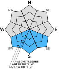
Early this morning, LOW avalanche danger exists for all elevations and aspects. Pockets of MODERATE avalanche danger will form quickly in response to daytime warming on SE-S-SW aspects at all elevations on slopes 35 degrees and steeper. On W-NW-N-NE-E aspects, avalanche danger will remain LOW with small, isolated human triggered loose wet avalanche activity unlikely but not impossible below 8,000' on slopes 35 degrees and steeper.

2. Moderate

?

Above Treeline
Heightened avalanche conditions on specific terrain features. Evaluate snow and terrain carefully; identify features of concern.

2. Moderate

?

Near Treeline
Heightened avalanche conditions on specific terrain features. Evaluate snow and terrain carefully; identify features of concern.

2. Moderate

?

Below Treeline
Heightened avalanche conditions on specific terrain features. Evaluate snow and terrain carefully; identify features of concern.
    Heightened avalanche conditions on specific terrain features. Evaluate snow and terrain carefully; identify features of concern.
Avalanche Problem 1: Loose Wet
  • Type ?
  • Aspect/Elevation ?
  • Likelihood ?
    Certain
    Very Likely
    Likely
    Possible
    Unlikely
  • Size ?
    Historic
    Very Large
    Large
    Small

The snowpack on SE-S-SW aspects remains in a transitional state. Under the relatively weaker and lower angle early February sun, daily melt-freeze cycles have been insufficient to produce corn snow conditions. What exists instead is a few inches of surface wet snow on top of colder, dry, less consolidated remnant storm snow, sitting on top of rain crust.

Once the thin ice layer of overnight snow surface refreeze is gone, marginally supportable conditions exist and the snowpack structure is conducive to human triggered loose wet avalanche activity. Snowpack failure has been occurring at the interface between the surface wet snow and the colder drier snow below it. In most areas this has manifested as human triggered roller balls and pinwheels. In more isolated areas human triggered loose wet avalanches large enough to bury or injure a person are possible in steep terrain. An incident occurred yesterday on Jakes Peak on the S to SE aspects above Emerald Bay where two skiers were caught and carried in a sizable loose wet avalanche.

The problematic surface wet snow over drier, colder snow structure is easily identified by hand pits as this structure exists within the top 6 to 8 inches of the snowpack in the vast majority of areas on SE-S-SW aspects. In areas where this snowpack structure exists, avoid travel on slopes steeper than 35 degrees and stay out from under steeper terrain above.

With 6 am air temperatures above 7,000' in the mid 30s to mid 40s in most locations, snow surface refreeze last night will have been entirely dependent on radiational cooling under clear skies. This superficial refreeze is expected to only be a couple of inches thick in most areas and will melt quickly today.

recent observations

A report was received of two skiers involved in a sizable loose wet avalanche yesterday on the S to SE aspects of Jakes Peak above Lake Tahoe's Emerald Bay. Reported details are extremely limited, but both skiers are understood to have been caught and carried. Both escaped burial and significant injuries. Isolated natural loose wet avalanches have been reported in recent days, but as the snowpack has had more time to transition, naturals have become unlikely with human triggering remaining the ongoing problem.

Snowpack observations made and received yesterday from Stanford Rocks (Ward Canyon/Blackwood Canyon area) and from Rubicon Peak (West Shore Tahoe area) indicated that NW-N-NE aspects held a well bonded and well consolidated snowpack. Up to 6 inches of cold unconsolidated surface snow was reported in wind protected areas above 8,000'. On the SE-S-SW aspects near Stanford Rock, any signs of overnight snow surface refreeze were gone by the late morning hours. By noon, 3 to 5 inches of surface wet snow on top of colder, drier, remnant storm snow over rain crust existed within the top 6 to 12 inches of the snowpack. This same upper snowpack structure has been observed on SE-S-SW aspects in numerous locations around the forecast area over the past several days.


Weather and CURRENT CONDITIONS
weather summary

High pressure continues to build over the region. Air temperature inversion conditions are in place, allowing for a more rapid warm up at the mid and upper elevations than on the valley floors. Remote sensors above 8,000' are reporting above freezing air temperatures for most locations. The colder spots are just a degree or two below freezing. A continued warming trend is expected for the next few days. Ridgetop winds shifted from SW to E yesterday evening as the high pressure ridge amplified to the west of the forecast area. Ridgetop wind speeds are in the upper end moderate range this morning. Wind speeds are expected to decrease slightly after sunrise, holding at light to moderate speed through tomorrow.

CONDITIONS ALONG THE SIERRA CREST BETWEEN 8200 FT. AND 9200 FT. IN THE LAST 24 HOURS
6am temperature: 29 to 37 deg. F.
Max. temperature: 42 to 48 deg. F.
Average ridgetop wind direction: SW shifting to E
Average ridgetop wind speed: SW 10 mph | E 30 mph
Maximum ridgetop wind gust: SW 19mph | E 47 mph
New snowfall: 0 inches
Total snow depth: 67 to 82 inches
Two-Day Mountain Weather Forecast Produced in partnership with the Reno NWS
For 7000 ft. to 8000 ft.
Sunday Sunday Night Monday
Weather: Sunny skies. Clear skies. Sunny skies.
Temperatures: 44 to 51 deg. F. 20 to 28 deg. F. 47 to 54 deg. F.
Mid Slope Winds: E E E
Wind Speed: 10 to 15 mph. 10 to 15 mph with gusts to 25 mph. 10 to 15 mph with gusts to 25 mph.
Expected snowfall: 0 0 0
For 8000 ft. to 9000 ft.
Sunday Sunday Night Monday
Weather: Sunny skies. Clear skies. Sunny skies.
Temperatures: 42 to 49 deg. F. 20 to 27 deg. F. 45 to 52 deg. F.
Ridge Top Winds: E E E
Wind Speed: 15 to 25 mph with gusts to 35 mph. 15 to 20 mph with gusts to 30 mph. 15 to 25 mph with gusts to 35 mph.
Expected snowfall: 0 0 0
Disclaimer

This avalanche advisory is provided through a partnership between the Tahoe National Forest and the Sierra Avalanche Center. This advisory covers the Central Sierra Nevada Mountains between Yuba Pass on the north and Ebbetts Pass on the south. Click here for a map of the forecast area. This advisory applies only to backcountry areas outside established ski area boundaries. This advisory describes general avalanche conditions and local variations always occur. This advisory expires 24 hours after the posted time unless otherwise noted. The information in this advisory is provided by the USDA Forest Service who is solely responsible for its content.