THIS AVALANCHE FORECAST EXPIRED ON January 7, 2016 @ 7:03 am
Avalanche Forecast published on January 6, 2016 @ 7:03 am
Issued by Steve Reynaud - Tahoe National Forest

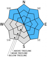
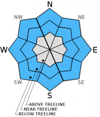
Considerable avalanche danger exists on all aspects and elevations today on slopes steeper than 32 degrees.  Wind slabs and storm slabs have been forming since yesterday and will continue to grow in size and sensitivity.  Storm slabs have shown the possibility for remote triggering and propagation across long distances.  Natural avalanches are possible and human triggered avalanches are likely today.  Dangerous avalanche conditions exist, cautious route finding and conservative decision making are essential today.

3. Considerable

?

Above Treeline
Dangerous avalanche conditions. Careful snowpack evaluation, cautious route-finding and conservative decision-making essential.

3. Considerable

?

Near Treeline
Dangerous avalanche conditions. Careful snowpack evaluation, cautious route-finding and conservative decision-making essential.

3. Considerable

?

Below Treeline
Dangerous avalanche conditions. Careful snowpack evaluation, cautious route-finding and conservative decision-making essential.
    Dangerous avalanche conditions. Careful snowpack evaluation, cautious route-finding and conservative decision-making essential.
Avalanche Problem 1: Wind Slab
  • Type ?
  • Aspect/Elevation ?
  • Likelihood ?
    Certain
    Very Likely
    Likely
    Possible
    Unlikely
  • Size ?
    Historic
    Very Large
    Large
    Small

Wind slabs formed yesterday on NW-N-NE-E aspects that were naturally and human triggered throughout the forecast area.  These wind slabs will remain sensitive today and will grow in size as our next storm impacts our region.  Winds will be South in the strong to gale force range and will switch to the Southwest in the afternoon and increase in speed.  8 to 16'' of new snow is forecasted for areas above 7000' throughout today and tonight.  These winds slabs will grow in size up to 2 to 4' deep and be located above treeline and near treeline on NW-N-NE-E-SE aspects.  If forecasted wind speeds materialize, wind slabs could also form in open areas in below treeline terrain.

Adjust your travel plan to avoid wind loaded areas.  Look for areas of blowing snow, cornice formation, wind pillows, and snow surface clues to help identify where wind slabs are located.

Avalanche Problem 2: Storm Slab
  • Type ?
  • Aspect/Elevation ?
  • Likelihood ?
    Certain
    Very Likely
    Likely
    Possible
    Unlikely
  • Size ?
    Historic
    Very Large
    Large
    Small

Several areas throughout the forecast region saw storm slabs failing at the new snow/old snow interface in near and below treeline terrain yesterday.  These storm slabs were avalanching both naturally and by skier triggering.  The bonds at this old snow/new snow interface have not had sufficient time to gain strength overnight.  Expect larger storm slabs today on all aspects near treeline and below.  These storm slabs could have the ability to propagate far distances, be remotely triggered, and run through below treeline terrain.  These storm slab may exist on some slopes but not on others depending on the strength of the old snow surface. 

These types of storm slabs may exhibit unusual behavior for our region and will require extra caution and more conservative travel planning.  Terrain viewed traditionally as "safe below treeline terrain" could be suspect today.  Avoid steeper slopes and terrain traps near or below treeline.  Use small, inconsequential test slopes to gather information.  Look for any cracking or signs of slab cohesion as clues for storm slabs


recent observations

Natural and human triggered avalanches were reported throughout the forecast area yesterday due to wind slab and storm slab instabilities.  On Andesite Peak (Donner Summit) and Becker Peak (Echo Summit) near and below treeline storm slabs were observed.  These storm slabs were failing at the old snow/new snow interface and propagating long distances.  On Silver Peak (Pole Creek) there was storm slab development in near and below treeline terrain.  Wind slabs were sensitive and easy to intentionally trigger along ridgelines.  On Frog Lake Cliffs (Carson Pass) and Powderhouse (Luther Pass) weather and snow amounts were more variable and signs of unstable snow existed.

Weather and CURRENT CONDITIONS
weather summary

A winter weather advisory remains in effect from 6am this morning until 1am Thursday morning.  8 to 16'' of new snow is expected throughout this storm with the highest amounts along the Sierra Crest above 8000' and lesser amounts East of Lake Tahoe.  The heaviest precipitation should be between 12 noon and 8pm today.  Winds are from the South and will switch over to the Southwest by this afternoon and be 40 to 50mph with gusts to 75mph above 8000'.

CONDITIONS ALONG THE SIERRA CREST BETWEEN 8200 FT. AND 9200 FT. IN THE LAST 24 HOURS
6am temperature: 15 deg. F.
Max. temperature: 27 deg. F.
Average ridgetop wind direction: South/Southwest
Average ridgetop wind speed: 25 to 30 mph
Maximum ridgetop wind gust: 58 mph
New snowfall: 6 to 10 inches
Total snow depth: 50 to 65 inches
Two-Day Mountain Weather Forecast Produced in partnership with the Reno NWS
For 7000 ft. to 8000 ft.
Wednesday Wednesday Night Thursday
Weather: Cloudy. Snow Cloudy. Snow Cloudy. Chance of snow.
Temperatures: 18 to 25 deg. F. 11 to 18 deg. F. 20 to 27 deg. F.
Mid Slope Winds: South Southwest Southwest
Wind Speed: 15 to 25mph with gusts to 40mph increasing to 30 to 40mph with gusts to 60mph. 25 to 30mph with gusts to 40mph decreasing 15 to 20mph with gusts to 30mph after midnight. 10 to 15mph with gusts to 25mph in the morning becoming light.
Expected snowfall: 4 to 8 4 to 7 Up to 2
For 8000 ft. to 9000 ft.
Wednesday Wednesday Night Thursday
Weather: Cloudy. Snow. Cloudy. Snow. Cloudy. Chance of snow.
Temperatures: 18 to 25 deg. F. 9 to 16 deg. F. 16 to 23 deg. F.
Ridge Top Winds: South shifting to Southwest in afternoon. Southwest Southwest shifting to West in the afternoon.
Wind Speed: 30 to 40mph with gusts to 60mph shifting to Southwest and increasing 40 to 50mph with gusts to 75mph. 40 to 45mph with gusts to 65mph decreasing 25 to 30mph with gusts to 45mph after midnight. 20 to 25mph with gusts to 40mph becoming west at 10 to 15mph with gusts to 25mph in the afternoon.
Expected snowfall: 6 to 10 4 to 8 Up to 3
Disclaimer

This avalanche advisory is provided through a partnership between the Tahoe National Forest and the Sierra Avalanche Center. This advisory covers the Central Sierra Nevada Mountains between Yuba Pass on the north and Ebbetts Pass on the south. Click here for a map of the forecast area. This advisory applies only to backcountry areas outside established ski area boundaries. This advisory describes general avalanche conditions and local variations always occur. This advisory expires 24 hours after the posted time unless otherwise noted. The information in this advisory is provided by the USDA Forest Service who is solely responsible for its content.